Scenario
Arctic air from the depths of Canada is set to slide south along the eastern edge of the Rocky Mountains and cruise over the top of the southern high plains starting Wednesday afternoon. The cold ridge of high pressure that is pushing south with stay in place through Sunday. This will open the door for wintry precipitation to fall across the Texas and Oklahoma panhandles and parts of eastern New Mexico and southeast Colorado.
The chance for snow, freezing rain and sleet isn’t the main story with this next change in the weather. The main story will be the very cold air that will settle across the area.
Highs will only manage the teens in some areas on Friday and Saturday. And with highs in the teens, that means lows will be down in the single digits to around zero.
By Sunday, temperatures will start to modify, but right now, it looks like a reinforcing shot of cold air may arrive by Sunday night.
Detailed Forecast
Wednesday
Increasing clouds and turning colder. That said, this is the big “what if” day as the timing for the cold front that is slated to push through is still uncertain. So, “what if” it shows up early (like the last one)? Temperatures will be markedly cooler across the area. The opposite will be true if it takes its sweet time, too. Right now Temperatures across the area will look like this
Thursday
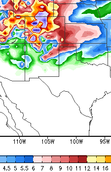
Right now, estimates indicate between 1″ and 4″ of snow possible for most of the Texas panhandle. About 3″ to 6″ possible across the western Oklahoma panhandle and northeastern New Mexico. Between 1″ and 3″ for eastern New Mexico and a dusting to 1″ for eastern Oklahoma and the eastern Oklahoma panhandle. Place south and east of a line from Wellington, Texas to Plainview, Texas will likely get a rain/snow mix and no accumulations.
Friday
Mostly cloudy and cold, again. The places that were experiencing a rain/snow mix will switch to all snow in the morning, but by then little to no extra accumulation is anticipated. Most of the precipitation – how ever it is falling – will taper to snow flurries through the morning. Into the afternoon a east and northeast wind should do just enough to keep passing flurries possible – west of a line from Liberal, Kansas to Silverton, Texas – as moisture is forced upward as it rides up the caprock. High temperatures will likely be held down by cloud cover and the arctic ridge. ook for afternoon temperatures to only manage the 10s and 20s.
Summary
In all, the main story is the cold air that is set to slide across the southern high plains and not necessarily the threat for snowy/wintry weather. That changes as you travel east into eastern Oklahoma, Missouri and Arkansas.
As the cold air presses south, chances are, the air will be too dry behind the front to hold enough moisture to give the area any real snowfall outside of a few inches.


