Scenario
A quasi-zonal flow with a few embedded systems will keep the southern high plains active in the coming days. This will increase the “prospects for precip” in the coming week. In fact, a relatively, active pattern will emerge by Monday where the Texas and Oklahoma panhandles have a chance for moisture every other day.
Right now, it appears that cold air will be in place and give the area a chance to see snow, sleet and freezing rain. One hurdle worth noting is this isn’t a classic panhandles snow storm. The computer weather models show a few passing open waves moving through, and not a closed-low plowing across the area. Often times, these open waves aren’t prolific snow-producers and have a tendency to leave us out to dry. As is the problem every time winter weather is in the forecast, this one will be difficult to nail down exact totals and the timing of any of the precipitation we are going to receive.
Detailed Forecast
Round 1: Late Saturday / Sunday
This looks to be the weakest of the incoming waves. The first returns on the radar will arrive late Saturday night and into Sunday morning. Most of the energy from this system looks to push south of the Texas and Oklahoma panhandles. West Texas and into southern Oklahoma looks like they will be the big winners with this first round.
That said, it’s only looking like 1″ to 2″ of snow will be possible in places like Lubbock, Texas through Wichita Falls, Texas and toward Lawton, Oklahoma. The passing snow showers should end from West to East by late Sunday night.
Round 2: Tuesday
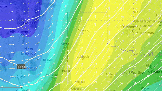
This might be the strongest of the next few systems, or not (more on the “or not” below). As this next wave approaches the panhandles will be in a prime location for both vorticity and vertical velocity. The 700mb vertical velocity shows plenty of ‘umph’ with the 500mb vorticity showing plenty of energy, too.
Computer weather models suggest a bulk of the moisture that falls Tuesday will fall as snow. That said, it could start as rain early in the day for places south of a line from Gage, Oklahoma to Clovis, New Mexico before the colder air filters all the way into the area. Early estimates put the snow totals at less than 3″ of accumulation across the panhandles with heavier amounts into parts of western Oklahoma and north Texas.
Right now, it appears that blowing and drifting snow may be the main concern. Returns on precip totals look to be in the 1″ to 3″ range, but north winds at 15 to 25mph gusting over 40mph may lead to reduced visibilities and drifts.
Round 3: Thursday / Friday
This may be the strongest system, depending on the computer weather model of choice. But, because it is so far out, it is tough to tell. This one doesn’t look at impressive at 700mb or 500mb – but because models suggest it might move slower, it may – in the end – offer a better chance for substantial precipitation.
Precipitation estimates from this system – and again, still a ways out – show an additional 2″ to 4″ possible.
Summary
In the end, simply put, it is nice to see precipitation chances returning to the southern high plains. It has been quite dry for some time and the area will take all the moisture it can get.
Snow chances, while they are improving still deserve an eye with some skepticism because this isn’t a “textbook scenario” for snowfall for the region.
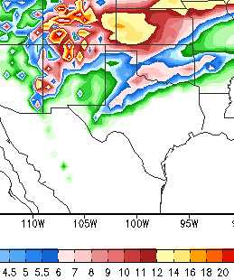
A fair forecast pegs the area with 2″ to 4″ of snowfall – that is snowFALL, not necessarily accumulation – with 1″ to 3″ of that snow actually sticking around and not melting. A few of the computer weather models – like the one to the left, the GFS – want to cover the area in a 3″ to 7″ blanket, but given the track of the systems, the available moisture and the lack of an honest-to-goodness closed low, a 2″ to 4″ snowfall is more likely
The other issue might be with drifting and blowing snow, which means that the 3″ of snow may turn into 10″ up against a fence or a building.
As always, we’ll continue to work out the details in the coming days. For a quick look at other weather graphics used to prepare this report click here. And please check back for updates!


