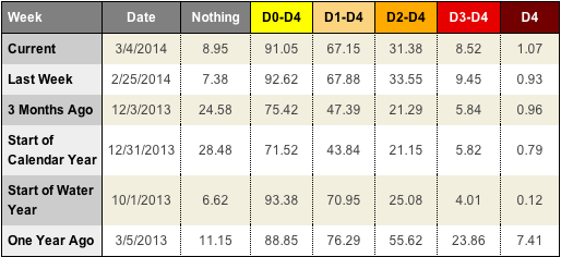
The majority of the Texas panhandle is still being monitored for severe, extreme or exceptional drought. During the last week, it might seem like the Texas panhandle received an unusual amount of precipitation, but it was only a drop in an empty bucket. There were a few passing thunderstorms rolled through the area on the night of February, 27th. Those were followed by light snow and sleet showers on March, 2nd and then another round of rain and snow moved across the area on March, 5th.
But, sadly, that isn’t unusual. In fact, the precipitation totals in the climate data tallied by the National Weather Service weren’t even above average. The area is so dry and has been for nearly three years that it just seems above average when precipitation falls more than once per week.
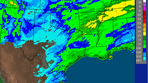
That said if you look at a precipitation estimates map of Texas, and if you leave East Texas out of numbers, the Texas panhandle and northern sections of West Texas were the big winners this past week.
And yes, it does show that portions of the Texas panhandle have tallied between one-half inch and a full inch of rain. But these are radar estimates and not “ground truth” readings. A good percentage of the precipitation that fell on the three events didn’t make it all the way to the ground.
But it is good to see, right? Maybe.
Taking a page from Climate Central, there may be a concern that the latest round of rain and snow might do just enough to hurt the area should it dry out again.
Climate Central posted an article suggesting that the recent California rains might be too little too late, so to speak, in terms of saving the state from a bad wildfire season. Instead, the rain is just adding fuel to those wildfires by perking up the grasses and brush.
The same could be said for the Texas panhandle and West Texas.
With wildfire concerns looming and the drought continuing, everytime the wind shifts to the southwest the area could be facing the same problem as California. Only on a more immediate – albeit inconsistent – basis.
In the last 15 years, the peak portion of “wildfire season” for the Texas panhandle and West Texas has been roughly late February to late April. This is when the air is often the driest, due to a downsloping southwest wind, and the wind is also the strongest.
In 2006, the dry gusty winds fueled a fire that burned nearly one-million acres across the panhandle. Then in 2011, another 70,000 acres burned.
Most of the two fires were fueled by periods of above-average rainfall. It would be careless to suggest that anything of that magnitude was possible during a drought and after a short burst of rain and snow. But, it bears mentioning that any added rain that helps to “green up” the area in a drier-than-average period is, yes, helping the drought, but is also helping add fuel to the wildfire dangers.
There is good news, though, it might be a while.
The Climate Prediction Center issued an El Nino Watch on March, 6th. That means there is a 50-percent chance that El Nino forms in – roughly – the next six to nine months. But they weren’t overly optimistic. Recall last year a similar situation unfolded and El Nino never did.
And things haven’t changed much in the Pacific. Even the CPC said in the report that “model predictions of ENSO for this summer and beyond are relatively unchanged from last month.”
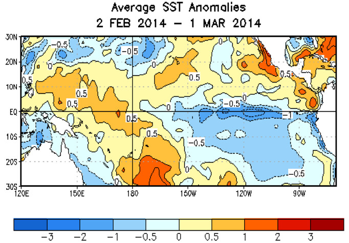
Looking at the data from Columbia University, it suggests a better chance that El Nino develops next winter
Often, an El Nino means more precipitation chances for the Texas panhandle and West Texas and, historically and statistically speaking, an El Nino year has translated to above-average rainfall. The curveball is that if El Nino would form in the summer, fall or winter, the 2014 wildfire season is not going to be tempered and the spring severe weather season which often offers considerable rain chances to these areas, won’t be as robust.
This also means that the drought will most likely continue across the Texas panhandle and West Texas. Even though it seems like the recent rain totals are unusual.


