Wednesday will prove to be a very close call for the Northeast. Right now, models are very close to one another in terms of projected path and wind speeds, but differ in the amount of precipitation totals.
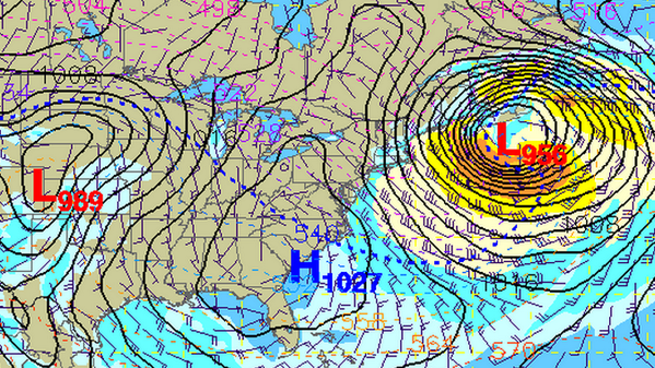
The NAM, ECMWF, UKMET, GFS, CMC and SREF paint a very similar picture of an area of low pressure off the coast of south carolina moving north-northeast and “Bombing” off the coast of Maine.
This question lies in the wiggle that is bound to occur as the storm moves north and how soon it deepens into a cut-off low.
Scenario 1: Deepens quickly and closer to shore
This would mean heavier snow amount farther inland. Places like New York City, Hartford, Providence, Boston, Bangor would see higher snow totals and more wind. Blizzard conditions would be likely in move of those locations and places in between, too.
Scenario 2: Deepens slower and father out to sea
This would create a wind event for most of the northeast with light snow amounts. There would be plenty of cold, but the same places listed above would only have to worry about wind chills and not snow depths.
Scenario 3: Somewhere in between
This is the most likely scenario. Chances are, as this storm drift up the coast, it will fall between the two above scenarios. There is a pretty decent likelihood that major Northeast cities see between 1″ and 4″ of snow with winds between 20 and 40 mph. Gusts up over 60mph will be possible across some of the coastal communities.
In any scenario
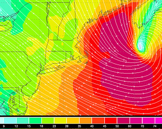
Places like Cape Cod and extreme eastern Maine still have to worry about heavy snowfall and blizzard conditions – for every scenario. In fact, right now it appears that those are the only two places that will be unable to escape blizzard conditions. Blizzard Watches have already been issued for a handful of counties in Massachusetts while Blizzard Warnings are in effect for parts of eastern Maine.
In those places that aren’t going to see a lot of snow, the wind will still be a concern with the cold temperatures. Sustained winds between 15 and 40 mph will be possible with gusts approaching 60mph possible along coastal communities. Temperatures will be stuck in the 20s and 30s meaning wind chills will be down in the single digits.


