11:00PM 8/24/15 UPDATE: Invest 98-L is now Tropical Storm Erika. Winds at 40mph. More details here
ORIGINAL POST: Danny is no longer a Tropical Depression. It is just a trough of low pressure. So for argument’s sake, it’s dead. If you’re a fan of Monty Python, it’s not quite dead yet. And it doesn’t want to go on the cart.
Per the National Hurricane Center:
Although an Air Force Hurricane Hunter aircraft found a few light westerly winds, they were neither strong nor extensive enough to support the existence of a well-defined circulation. In addition, surface synoptic data from the Lesser Antilles suggest that the system has degenerated into a trough. The system also lacks sufficient organized deep convection to qualify as a tropical
cyclone. Therefore, this is the last advisory on Danny.The remnants of Danny should continue to move westward over the northeastern Caribbean, and global model guidance show the system
losing its identity within 48 hours or less.
As anticipated, Danny didn’t live very long. And, thankfully, didn’t cause much damage.
And then, there were two
Danny’s death leaves two areas of concern in the Atlantic.
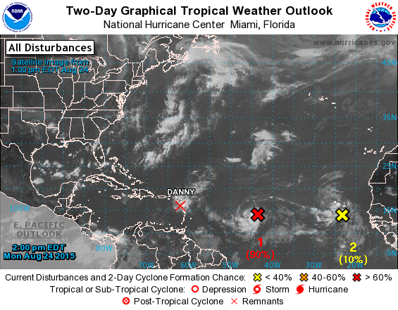
One has an almost certain probability of development. The other, not so much. This is the official word on both areas of interest from the National Hurricane Center:
1. Shower and thunderstorm activity associated with a low pressure system [Invest 98-L] located about 950 miles east of the Lesser Antilles continues to show signs of organization. Conditions appear favorable for development, and this system is likely to become a tropical depression or a tropical storm during the next day or so while it moves westward near 20 mph.
* Formation chance through 48 hours…high…90 percent
* Formation chance through 5 days…high…90 percent2. A tropical wave and associated low pressure area located near the Cape Verde Islands is accompanied by disorganized showers and
thunderstorms. Environmental conditions are not expected to be conducive for significant development of this system while it moves
westward at 15 to 20 mph over the next few days.
* Formation chance through 48 hours…low…near 10 percent
* Formation chance through 5 days…low…10 percent
Right now, it looks like the first one, Invest 98-L, soon to be named, Erika, will likely strengthen in the coming days. As of this writing there was plenty of thunderstorm development around the center of weak circulation.

Most model guidance suggests it will become a Tropical Storm in the next 24 hours. A few of those computer weather models suggest a Category One Hurricane in the next 72 hours. Here is a look at one chart from the Tropical Tidbits page:
Notice, though, that most of the models keep the storm at Tropical Storm strength through the next 96 hours (Keep that in the back of your mind as you continue to read). Meaning that the Leeward Islands, Puerto Rico, the Dominican Republic and Haiti would likely need to brace – again – for a tropical storm and not a hurricane.
Before you run to the store and buy up all of the batteries, water, and Pop Tarts – look at the following three pictures. They show the suggested track of Invest 98-L.
Notice the only model that picked up on Invest 98-L truly getting it’s act together was the GEM. That is the Canadian model. It is notorious for “making a mountain out of a molehill” with tropical storms. I only show it to highlight that sometimes you need to know what you are looking at before you make a judgement on how reliable it is. Some of these models tend to cry wolf a lot.

The track will really be dependent on how much Invest 98-L strengthens (remember that thing I told you to keep in the back of your mind?). If it becomes stronger, some models suggest it may have a tendency to drift farther north. If it stays as a tropical depression or tropical storm, those same models suggest it may take more of a southerly track.
And as you look further out into the future, these models become more inconsistent with strength and track. This is what makes tropical forecasting so difficult.
Okay, we’ve seen the graphics and read the info – what’s the forecast?
The forecast is that in the next two to four days Invest 98-L will meander toward the Caribbean and is most likely going to slide along a similar path as Danny. The difference is that the dry air and wind shear that tore apart Danny will not be as drastic, so development and strengthening is likely.
We will likely have a Tropical Storm by Tuesday morning.
It is possible we will have a Hurricane by Wednesday afternoon.
Beyond that, the track is still – both literally and figuratively – up in the air. Like it was mentioned above, the track of Invest 98-L is going to depend on how muc it strengthens, so offering a track beyond two days at this point is relatively futile. That said, the graphic on the left is a look at the forecast track as suggested by a handful of computer weather models from the Tropical Tidbits page.
This is one that has our ears perked up a little more than Danny, but at this point is still too far away to be a direct concern. We will continue to keep our eyes on it and give updates as they are available.


