Usually, clearing one hurdle at a time is the best way to handle weather, but in this case, it is important to jump on this before the preoccupation with flooding leads to a missed opportunity to warn about the threat for more severe weather.
The Setup
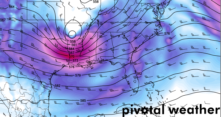
A cut-off Low lifts out of Texas and into Mississippi and Tennessee as a second area of low pressure comes swinging in from the west. The second area of low pressure will bowling ball its way from Sante Fe, NM to Little Rock, AR by Sunday March 13th, 2016.
 At the same time, moisture will continue to stream in from the Gulf of Mexico at the lower- and mid-levels. PWAT values near 1.0″ as well as surface dewpoint values in the mid 60s will help destabilize the atmosphere. Favorable wind fields will also help to open to door for scattered showers and storms in Oklahoma, Arkansas, Louisiana, and Mississippi.
The most interesting part of this, is while the atmosphere is ripe for the development of severe weather, it appears that only a few select places will truly have a threat to see any.
The Breakdown
Going form top to bottom, the atmosphere is pretty amped for the development of severe weather across a larger area than will actually see severe weather. This threat – while not surprising – will be localized to the area of low pressure swinging through the area.
From the SPC:
ABOVE-AVERAGE CONSISTENCY EXISTS WITH THE EVOLUTION OF A COMPACT SHORTWAVE TROUGH EXPECTED TO BE OVER NW TX AT 12Z/SUN. THIS FEATURESHOULD TRACK INTO THE MID-SOUTH BY EARLY MON. AN ATTENDANT SURFACE CYCLONE SHOULD PROGRESS ALONG THE RED RIVER THROUGH THE AFTERNOON WITH AN ATTENDANT DRYLINE ARCING ACROSS EAST TX. LOW-LEVEL WINDS SHOULD GENERALLY REMAIN SWLY YIELDING LARGELY CONTINENTAL TRAJECTORIES. NEVERTHELESS…A PLUME OF UPPER 50S TO LOWER 60S-TYPE SURFACE DEW POINTS SHOULD BE MAINTAINED WITHOUT A SUBSTANTIAL AIR MASS CHANGE IN THE WAKE OF THE UPPER LOW /CURRENTLY OVER NRN MEXICO/THAT EJECTS NEWD IN PRECEDING DAYS. THIS SHOULD BE SUFFICIENT TO GENERATE WEAK TO MODERATE BUOYANCY AS MID-LEVEL LAPSE RATES BECOME STEEP. DEEP-LAYER SHEAR WILL BE STRONG WITHIN A COMPACT SWATH OF 700-MB WINDS AOA 50 KT AND 500-MB WINDS AOA 65 KT. THIS SETUP SHOULD FOSTER INITIAL SUPERCELL DEVELOPMENT NEAR THE ARKLATEX IN THE AFTERNOON…THAT MAY EVENTUALLY CONSOLIDATE INTO A PROGRESSIVE CLUSTER TOWARDS THE ARKLAMISS BY EVENING.
Looking at the 00z GFS from 3/11/16, the severe weather parameters are evident for a much broader area than the 15% outlined by the SPC. Here is a look at the severe weather parameters for the region at 7pm Sunday night.
But don’t let the quick glance forecast fool you. It looks like the amount of forcing in the lower levels may not be enough to get storms off the ground.
Notice the difference from the 12z (midday, two on left) to the 00z (late night, two on right) model runs. The first two show a stronger area of forcing in the red, falling apart as it pushes across parts of central Mississippi and into Alabama. While the 00z data shows a less robust area of forcing falling apart, too.
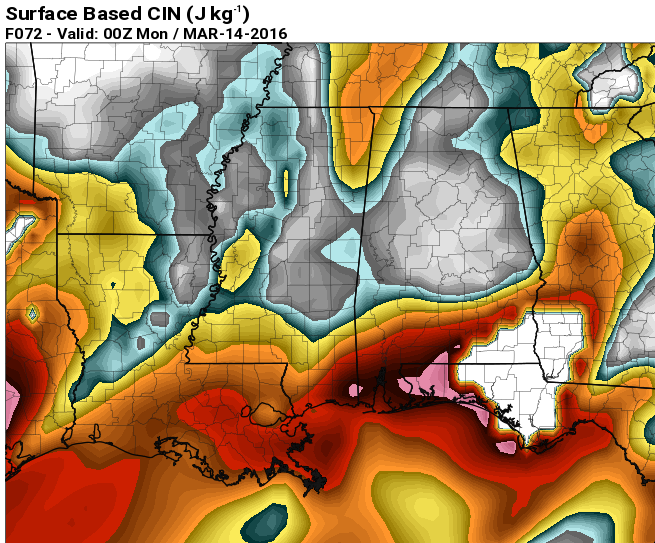
Also, we will have a lot of CIN, too. And CIN i something I don’t know that I’ve ever discussed. I won’t get into it here, but it is simply anti-CAPE. And any time you get CIN values over 100, you start to have enough to stomp out any chance for thunderstorm development – especially without ample forcing.
What does the CIN looks like?
CIN-y man. Get it? Like cinnamon, but CIN-EE, man. Okay, bad joke.
But a good look at a parameter that will likely do a lot of keep convection – showers and storms – at bay on Sunday. Anywhere you get into the yellows you start to see enough CIN to hold off storms, by the time you get into the oranges and reds, it gets very tough to get storms rolling.
The Bottom Line
If you are in that 15% area outlined above, you are in an area that could see some very heavy rain, gusty to damaging winds, small hail, and a few isolated tornadoes. While storms are not in the forecast for a large area in the Mid-South and Southeast on Sunday, the area may grow int he coming days as the models continue to get a better idea about where this next system may go. So if you live in Louisiana, Mississippi, Alabama, Kentucky or Missouri, you may want to keep an eye on the forecast as you may be in the bulls-eye for severe weather on Sunday, too.


