As an area of low pressure strengthens coming out of the Rockies and slides northeast from Colorado to Wisconsin, it will swing a cold front across the Southern Plains, Mid-South and Gulf Coast Wednesday and Thursday.
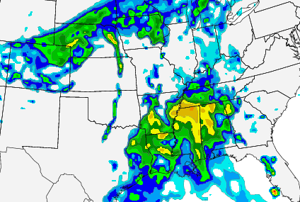
Along the front, showers and storms may develop from as far south as Austin, Texas back north toward Omaha, Nebraska. And as far east as Atlanta, Georgia. Given the high moisture return and the divergence aloft, this will spell the opportunity for severe weather.
If you’re just here for the down-and-dirty forecast… head to the bottom of the page!
For everyone who wants to know about the nitty-gritty nerdy details, take a look! We will be breaking everything down using the 12z run of the NAM model from 3/28/16. We will be examining the 00z Thursday timeframe, also known as Wednesday afternoon/evening.
The Setup
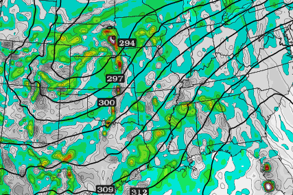
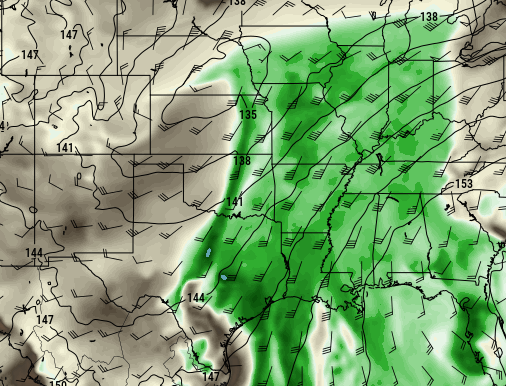
AT 300MB:From the top down on Wednesday afternoon and evening, the atmosphere is looking consistent with historical situations that produced severe weather. At 300mb, winds across parts of the Texas panhandle, Oklahoma, Kansas and Nebraska will be out of the southwest at 70kts to 110kts. With a second area of 70kts to 110kt flow across parts of Mexico and southern Texas. During this timeframe, the winds at 300mb are circling around the bottom of an area of low pressure centered around Las Vegas. As they exit the bottom of the Low, the winds slow and the pressure gradient relaxes. As the pressure relaxes, it allows for buoyancy beneath it.
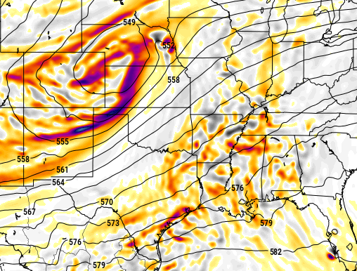
AT 500MB:At the same time, the area low pressure at 500mb will be centered around North Platte, Nebraska. The strongest winds at this level will be across the Texas panhandle, into Oklahoma, Kansas,Missouri and Iowa. At 500mb, meteorologists often look at vorticity – or a change in wind speed and direction – at this level. That often gives meteorologists an idea where the most energy will be. In this case, during this time period, the most energy will be across parts of Texas, Oklahoma, Kansas and Nebraska. But – !!! – it will not be in the same area as the highest instability, wind shear or PWATs.
Winds from the southwest for the Southern Plains flatten and become more westerly into the Mid-South and Gulf Coast regions. But, in this time frame, maintain speeds above 40kts. This can be helpful in produce storms with some semblance of organization.
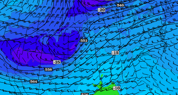
Temperature can be a biggie for certain sections of the country. And in certain scenarios. For example, in southern Mississippi it is very difficult to get severe weather when the 500mb temperature is not below -10 degrees Celsius. There are, obviously, exceptions to this rule. When the temperatures at the lower levels are much higher, but generally, the rule works.
During this time period, that -10C line is pushed all the way down to the coast of Louisiana. The -15C line runs from Lubbock, Teas to Kansas City, Missouri and back to Montgomery, Alabama. Meaning places north of that line will be at or below -15C at 500mb. The -20C line runs from Amarillo, Texas to Lincoln, Nebraska – points north and northwest of that line will be at or below -20C.
So there should be sufficient cold air aloft for storms to use.
AT 700MB:Often here, a look at vertical velocity is helpful. But that’s not all, we also need to look at wind, dewpoint and temperature. At this level and during this time frame, winds will be consistently from the southwest across all regions. Wind speeds will be between 30kts and 40kts. Dewpoint values will be highest across the Gulf Coast region and dry out as you move back toward the Mid-South and Southern Plains. The freezing line at 700mb goes from about Amarillo, Texas northeast toward Des Moines, Iowa.
In the place where the dewpoint is closest to the temperature, you usually have clouds, and depending on the situation, precipitation. In the places where the dewpoint is farther away from the temperature the dewpoint depression – the difference between the two – is higher. That will come into play when trying to decide is severe weather is possible.
Vertical velocity will be strongest near the cold front where air parcels will have the most tendency to want to ascend. There is going to be another place where vertical velocity is higher, and that is along the Gulf Coast where surface and low-level dewpoints will be high enough to promote buoyancy from thermodynamics rather than kinetics.
AT 850MB: This is where things get juicy. Now it is important to really key in on dewpoint, wind speed and direction, and where the air comes from. The dewpoint at 850mb will be above 10 degrees Celsius as far north as Des Moines, Iowa, Chicago, Illinois and Indianapolis, Indiana. Wind speed will be at or above 35kts from the south or southwest from Mobile, Alabama to Louisville, Kentucky back to Kansas City, Missouri and south to Dallas, Texas.
The last one, where the air comes from, may not seem like it matters, but – on a personal note – I’ve found it to be very useful in a lot of situations. To figure this out we follow the wind direction in reverseIn this case, the wind is coming from the Gulf of Mexico. But going back 24 hours, the figuring out where that wind is coming from can tell us a lot of how airmasses are going to interact. In this case, a south-southeast wind across the Gulf from the Caribbean is depicted. That means there will be a small influence of Caribbean air across the Gulf Coast and Mid-South. And Caribbean air is often quite warm and moist.
The Breakdown
With the above pieces in place, severe weather does look possible. The severe weather parameters given by the 12z are impressive, but not completely lined up for a widespread severe weather outbreak. Times when CAPE (instability) is the highest, Shear isn’t as high. When Helicity is high enough, LCLs aren’t favorable.
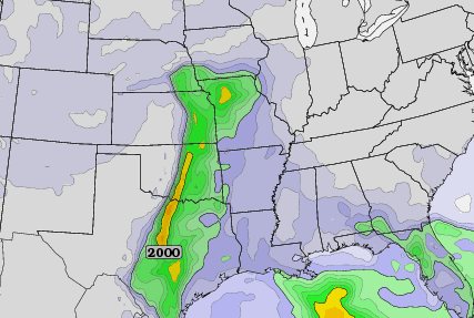
Overall CAPE values during this timeframe across eastern Kansas, western Missouri, Oklahoma and north Texas will be between 1500J/Kg and 2500J/Kg. Instability in the Mid-South and Gulf Coast will be between 300J/Kg and 700J/kg.
Shear will be best across the Texas panhandle, north Oklahoma, central Kansas, Nebraska, and Iowa. There, Bulk Shear values between 40kts and 70kts will be possible during this timeframe. A secondary area of 35kts to 50kts of Bulk Shear will be across southern Louisiana and southern Mississippi.
Storm Relative Helicity will be highest over Nebraska, Iowa and Missouri, down toward Arkansas and Mississippi. In the north, values between 300m/s and 500m/s are shown. To the south in Arkansas, especially, values will exceed 400m/s and in Arkansas case exceed 600m/s.
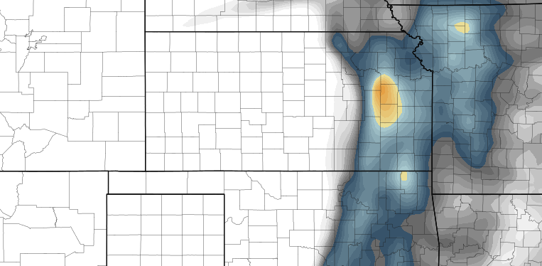
The Significant Tornado Parameter shows a slice from St. Joseph, Missouri to Topeka, Kansas and south to Tulsa, Oklahoma with the highest values. Values there range from 1.5 to 3.
Final Thoughts Before the Forecast
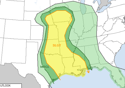
It looks like there will be a few corridors where there will be sufficient sever weather parameters inside of the area capable of maintaining severe weather during the timeframe discussed. And, while the Storm Prediction Center has highlighted the entire region, it looks like the areas of highest concern based on this one model may be in eastern Kansas, central and eastern Oklahoma as well as north Texas, as well as eastern Louisiana, souther Mississippi and central Alabama.
One thing to note here, this is only one model. And only one run of one model. Please don’t take this as the end-all be-all forecast.
The Forecast
Severe weather is possible Wednesday for the areas discussed. The Storm Prediction Center in Norman, Oklahoma highlighted a 15% risk area yesterday and upgraded it to a Slight Risk today.
Storms will be possible starting as early as Wednesday afternoon across parts of Oklahoma and Kansas. The cap may be tough to erode in this area, but it looks like sufficient low-level moisture will be present to overcome the cap. Elsewhere, in the Mid-South and Gulf Coast, showers look to develop in the afternoon and evening. Some of these first storms may be discrete and severe. If the cap here is weak and storms fire and clump together, the overall threat for severe weather may wane.
Specific threats are tough to pin down at this distance in time, but in the Southern Plains there will be sufficient instability to promote the development of some storms with heavy rain, frequent lightning, damaging wind, large hail and a few isolated tornadoes. In the Mid-South, if storms start and stay discrete, heavy rain frequent lightning, hail and damaging winds look to be the main concerns. If LCLs stay low enough and CAPE can get high enough, and storms stay discrete, tornadoes could be possible, too. The same is true for the Gulf Coast.
THIS ALL CHANGES BY WEDNESDAY NIGHT LATE AND INTO THURSDAY MORNING!
While I didn’t ahve time to break down the timeframe from 8pm WED to 8am THUR please know that severe weather will still be possible in the Mid-South and Gulf Coast. The severe threat should diminish after sundown in the Southern Plains.


