UPDATE 3/30/16 9:30AM: For the latest numbers / forecast for south Mississippi, click here
ORIGINAL POST:
The Storm Prediction Center has put Louisiana, Mississippi and Alabama under either a Slight Risk or Marginal Risk for severe weather both Wednesday and Thursday.
While I don’t have time to get into the nerdy details here, if you are looking for that, head here
Timing
Because I know this is the most important part, let’s cut to the chase…
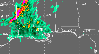
WEDNESDAY AFTERNOON
Showers and storms will break out across parts of Louisiana and western Mississippi during this time period. Some of these will be strong to severe. The atmosphere is setup to sustain all severe weather modes (heavy rain, frequent lightning, damaging winds, hail, tornadoes). While the placement of individual parameters with relation to storm development is still in question, generally, there threat for sever weather will persist during this time.
From the SPC:
GIVEN POSITIVE TILT OF TROUGH…ASSOCIATED FLOW/MASS-FIELD GEOMETRIES…AND POTENTIAL FOR EARLY-PERIOD CONVECTION TO ERUPT OVER PARTS OF TX/OK…SCENARIO REGARDING TIMING/PLACEMENT/EVOLUTION OF GREATEST SVR POTENTIAL REMAINS FRAUGHT WITH UNCERTAINTIES FOR MOST OF SLGT-RISK AREA. AS SUCH…WILL CONTINUE WITH BROAD BRUSH ON UNCONDITIONAL PROBABILITIES…ACKNOWLEDGING THAT 30%/TOTAL-SVR CONCENTRATION ULTIMATELY IS LIKELY TO BECOME APPARENT ON MESOSCALE SOMEWHERE BETWEEN ERN NEB AND UPPER TX COAST. RELATIVE GAP MAY BE PRESENT IN SVR POTENTIAL OVER SOME PARTS OF SRN KS OR OK BETWEEN REGIMES DISCUSSED BELOW…HOWEVER UNCERTAINTY IS TOO GREAT ATTM TO DRAW EITHER TWO SEPARATE OUTLOOKS OR AREAL INDENTATION.
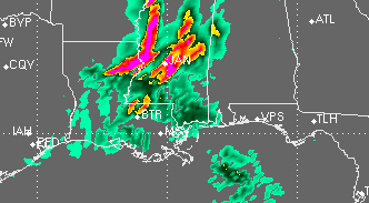
WEDNESDAY OVERNIGHT
As it looks right now, Scattered storms will clump into a line and push across the state of Louisiana between 10pm and 4am as a cold front sweeps through. Latest model trends develop storms ahead of the line into western Mississippi during this time period. With an increase in the low-level jet and continued ML CAPE above 500J/Kg the threat for severe weather will continue with storms that develop.
During this time period, the threat for hail may decrease while the threat for isolated tornadoes may increase. Please check back for more details as the forecast gets refined.
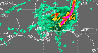
THURSDAY MORNING
The line of storms will move into western Mississippi from the Tennessee border all the way down to McComb. The line will push across the state between 4am and 8am. During this time period all severe weather modes (heavy rain, frequent lightning, damaging winds, hail, tornadoes) will be possible. And due to an increase in low-level Helicity and Bulk Shear values, the threat for tornadoes may increase. In fact, when suggested severe weather parameters are compared against historical averages, the atmosphere does look ripe for the development of at least one or two tornadoes.
From the SPC:
VIGOROUS/BROAD REGIME OF LOW-LEVEL WAA AND MOISTURE TRANSPORT SHOULD SUPPORT MULTIPLE EPISODES OF CONVECTION ACROSS LOWER MS VALLEY AND SERN CONUS THROUGH PERIOD ALONG/AHEAD OF COLD FRONT…AMIDST FAVORABLE DEEP SHEAR. SOME OF THIS ACTIVITY MAY BE ONGOING AT START OF DAY-3 PERIOD IN BROAD SWATH FROM UPPER GREAT LAKES TO MS…MOST OF IT ELEVATED WITH MRGL SVR THREAT.
LAPSE RATES SHOULD BE MODEST ALOFT OVER MOST OF THIS REGION…GIVEN TWO FACTORS…
1. MID/UPPER-LEVEL TRAJECTORIES LACKING ROBUST EML AIR…IMPLIED BY POSITIVE TILT OF LARGER-SCALE TROUGH AND EJECTING/WEAKENING NATURE OF LEAD SHORTWAVE.
2. ABUNDANT CONVECTION DAY-2 CARRYING INTO THIS PERIOD.HOWEVER…DEEP SHEAR WILL BE FAVORABLE FOR SVR…AND GREATEST POTENTIAL FOR JUXTAPOSITION OF RICH LOW-LEVEL MOISTURE WITH THAT SHEAR IS OVER CATEGORICAL SLGT RISK AREA. MESOSCALE BOUNDARIES AND CONVECTIVE PROCESSES WILL STRONGLY REGULATE ACTUAL POTENTIAL WITHIN THIS BROAD PLUME. COMBINATION OF WEAK LOW/MIDDLE-LEVEL LAPSE RATES AND LACK OF APPARENT DEEP-LAYER FORCING MAKES SVR THREAT LOWER AND MORE UNCERTAIN EWD THROUGH CAROLINAS.
The line will then move through Alabama between 7am and 12pm. At this time, the convection mayt lose a little steam, but all modes of severe weather will continue to be possible.
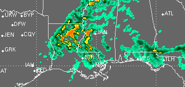
THURSDAY AFTERNOON
Depending on how much the morning storms work over the atmosphere, there may be additional development of severe weather Thursday afternoon for parts of Louisiana and Mississippi. Because this will be dependant on morning convection and the amount of clearing, I will hold off on mentioning the threat for bad weather here, but please check back for an updated forecast.


