Often times you hear meteorologists talk about instability when discussing the potential for severe weather. Usually, if severe weather is in the forecast the instability will either be “high” or “modest” when speaking generally. At times the instability can be “low” while offering just enough to get severe weather off the ground.
But, scientifically speaking, instability has a specific term. That term is CAPE.
This is storm Superhero stuff
Now you might be asking: “Nick? capes? Are we talking about Superman…?”
Sadly, we are not. CAPE is short for Convective Available Potential Energy. That is, we are looking at the potential energy available for a buoyant parcel of air.
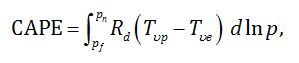
Mathematically, it looks like this
More from the American Meteorological Society:
Where Tυp is the virtual temperature of a lifted parcel moving upward moist adiabatically from the level of free convection to the level of neutral buoyancy, Tυe is the virtual temperature of the environment, Rd is the specific gas constant for dry air, pf is the pressure at the level of free convection, and pn is the pressure at the level of neutral buoyancy. The value depends on whether the moist-adiabatic process is considered to be reversible or irreversible (conventionally irreversible, or a pseudoadiabatic process in which condensed water immediately falls out of the parcel) and whether the latent heat of freezing is considered (conventionally not). It is assumed that the environment is in hydrostatic balance and that the pressure of the parcel is the same as that of the environment. Virtual temperature is used for the parcel and environment to account for the effect of moisture on air density.
In English
I know, I know. It sounds super fancy, but it really isn’t as difficult to follow as it may feel. It is just measuring if a pocket of air (parcel) is more likely to move upward in the atmosphere given a handful of attributes expressed by a certain portion of the atmosphere.
And, this isn’t a given, as I pointed out a few years back…
All of this is also known as instability. Instability is something everyone with an “Ex” knows about, am I right?
Okay, jokes aside, think about instability/CAPE like this.
The larger the CAPE value the more unstable the atmosphere is. If the atmosphere is unstable then there is more buoyant energy in a pocket of air. If a pocket of air has more energy to be more buoyant, it will rise faster. And remember that rising air is also known as an updraft.
So, if an updraft is rising faster, it allows for storms to build more quickly. It also allows for storms to hold larger hail and produce more damaging tornadoes.
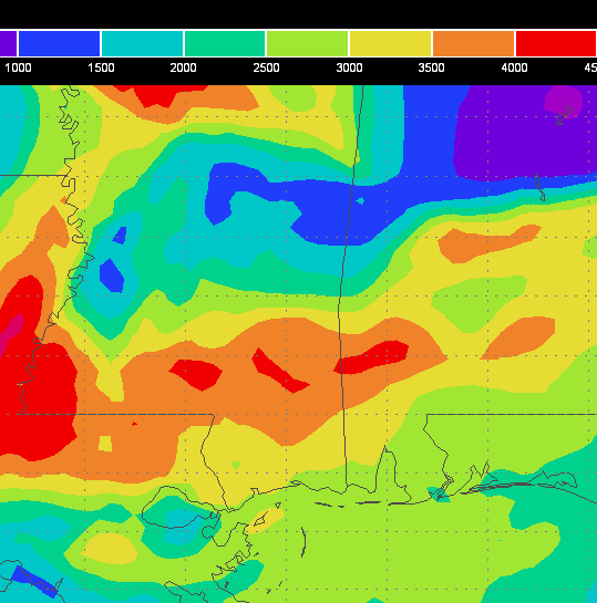
A general idea of different CAPE value tiers:
- 0-500 = Low Instability
- 500-1000 = Marginal Instability
- 1000 – 2500 = Moderate Instability
- 2500 – 3500 = High Instability
- 3500+ = Extreme Instability
Keep in mind CAPE values aren’t the end-all-be-all for severe weather. But they are on of the contributing factors we look at when dissecting the atmosphere. Location often dictates if CAPE plays a larger or smaller role in the general threat for severe weather, while for specifics, it will always depend on each individual storm system.


