(UPDATE 3:30PM)
It looks like afternoon storm initiation is getting moving across parts of east Texas, southern Arkansas and northern Louisiana. We’ve decided to leave our tornado threat graphic alone today since it was issued at 6:00am. So far it is still holding true.
(ORIGINAL 7:30AM)
First, having a severe weather plan is important. Especially on days like today. And not just a plan for a tornado.But what would you do if large hail started crashing through your windows? Or if straight-line blew off your roof.
These things can happen in a severe thunderstorm – even one without a tornado. So please talk to your family about what you would do if a severe thunderstorm was moving toward your home.
Okay, that said, let’s take a look at what to expect across the country today.
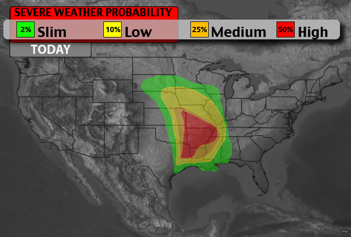
Right now, there is the threat for severe weather from Omaha, Nebraska all the way south to Beaumont, Texas. From Oklahoma City, Oklahoma to Memphis, Tennessee.
With such a broad area for severe weather, it is difficult to get everyone an accurate timetable for events, but by zone, it might be a little easier.
Oklahoma, Arkansas, Texas, Louisiana
9AM – 1PM
Short-range models want to break out showers and thunderstorms in central/eastern Oklahoma, northeast Texas and western Arkansas this morning around 9am. This is already ongoing in parts of central Oklahoma, this morning. As a line of storms is currently muscling through Oklahoma city. These will be multicellular and linear. The main threats with these storms will be heavy rains, damaging winds and large hail.
The tornado threat is there, but this isn’t the time of the day that the main concern for tornadoes will be today.
1PM – 5PM
The line of thunderstorms above will eventually fall apart and move out of the area. Behind those, a few popcorn storms will dot the landscape across eastern Texas, eastern Oklahoma, Arkansas and Louisiana. Models indicate the atmosphere will be “recharging” so to speak, during this time period. If you find yourself beneath or in the path of a popcorn storm, the main threats will be heavy rains, high winds, hail and cloud to ground lightning.
A tornado cannot be ruled out, but since these storms will be likely lack sufficient organization, the threat is lower.
5PM – 9PM
This is when the threat for a tornado will be the highest. Computer weather models suggest another line of storms will erupt along the Oklahoma / Arkansas border and stretch back into far eastern Texas and northwest Louisiana. Storm initiation looks to start around 6pm. These storms will move northeast across Arkansas and into Missouri.
The main threat with these storms will be damaging winds in excess of 70mph and hailstones up to the size of baseballs. There is also a concern for flash flooding and this is also when the tornado threat will be highest. The RAP computer weather model soundings for Helicity indices and CAPE values, as well as hodograph soundings, point to stronger tornadoes as a possibility. It cannot be ruled out that more than one tornado warning is issued at any given time during this timeframe.
(UPDATE!!!) Kansas, Missouri, Iowa, Illinois
12PM – 5PM
Thunderstorms – some severe – will move northeast across eastern Kansas and into Iowa and northern Missouri. These storms will have quarter hail and 60mph winds.
The line will reorganize around noon and push northeast across eastern Kansas, western Missouri and southern Iowa. Within this line of storms, cells could remain isolated. According to the the computer weather models, the atmosphere will be supportive of severe weather with this line of individual cells, too. Given Helicity values, CAPE values and hodograph readings, the main threats will be high winds and hail. Also, given the cloud deck will be low, and low-level shear will be sufficient, a tornado cannot be ruled out.
Between 3pm and 5pm, there is some indication that storms in Iowa – and even Nebraska – will have the potential to drop a tornado or two.
The storms that develop in eastern Missouri will move northeast into Illinois. During the time the main threats will be half-dollar hail, winds in excess of 60mph and an isolated tornado. That said, the RAP compute weather model isn’t as confident with the severe weather parameters in this area during this time. And it bears watching very, very closely. I wouldn’t let your guard down, but keep in mind you might be able to “dodge an afternoon bullet” so to speak.
5PM – 9PM
The line of storms that fires in western Arkansas will eventually push into southern Missouri and this is when the greatest threat for severe weather will be. Right now the RAP is showing plenty of Helicity, CAPE and hodographs supportive of stronger tornadoes.
The main threats from these storms will be heavy rains, golfball hail, winds in excess of 70mph, and scattered tornadoes. It cannot be ruled out that more than one tornado warning is issued at any given time during this timeframe.
For Iowa and Illinois, severe thunderstorms with hail and high winds are most likely during this time. The tornado threat isn’t zero, but it won’t be as high as to the south.
In a Nutshell
For a look at a few maps, check out our severe weather potential page. Have a severe weather plan if you live in these areas. Don’t wait too long to seek shelter. If you don’t have a study building to seek shelter in, find one now and know how long it will take you to get there in case severe weather strikes.
For an idea of what the Storm Prediction Center is thinking at the National Weather Service, click here
Also, keep in mind that flash flooding is a major concern for some areas. The National Weather Service anticipates between 2″ and 6″ of rain to fall across parts of the southeast in the coming five days. And most of it will fall at one time or during a 48 hour period.

There is the threat for severe weather again in some of the same areas tomorrow. A detailed write up on that will be coming tomorrow. As the day continues and we work into tomorrow morning, we will continue to monitor this situation closely. A severe weather breakdown with a timetable of events will be posted. If you haven’t already, bookmark the site and follow us on twitter or check us out on facebook. And, as always, check back for updates!


