Twenty-plus inches of rain. Louisana may have a lot of swamps and wetlands, but even that state can’t handle this kind of rain. And as neighbors in central and southern Louisiana look to each other for help during a massive flood, Alabama and Florida coast folks are glad they only got 5″ to 10″ of rain.
Meanwhile in Mississippi, most people are breathing a sigh of relief. Finally one missed Mississippi. Mostly.
The Mississippi Gulf Coast, in places like Bay St Louis, Pass Christian, Diamondhead and Gulfport, picked up enough rain to flood streets for a few hours. But generally, Mississippi missed the party.
And it is a combination of weird hiccups from Mother Nature.
On Wednesday…
Dry air intrusion saved most of the area from picking up substantial rainfall. Thunderstorms moved across the area, but general rain totals across the area only topped out around 0.5″ to 0.75″ and most storms didn’t drop torrential rain.
Places like Leakesville, Lucedale, Wiggins and points nearby saw the heaviest rain with totals approaching an inch, but overall the Pine Belt was spared due to dry air in the mid levels.
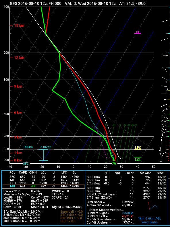
What did that look like to meteorologists? Well, the Skew-T chart here gives you an idea (Learn about Skew-T charts here). Remember that the red and green lines indicate temperature (red) and dewpoint (green), When those lines get close together, you have a more saturated atmosphere and when they move apart you get a drier atmosphere.
A special “Thank You!” to the people at Pivotal Weather and Twisterdata for allowing us to use their awesome graphics.
And in places where the lines are close together and you have some sort of atmospheric forcing, like a front or area of low pressure, you often get rain (or snow in the winter).
But that isn’t what happened across the Pine Belt.
Not only was there drier air between 700mb and 300mb, but the amount of Vertical Velocity (the propensity for air to move up, cool, condense, and – in this case – rain itself out) wasn’t there!
Dry air from Georgia drifted over the top of the area while, at the same time, all of the Vertical Velocity was off the coast.
So not only was it dry in the mid-levels, which would’ve slowed the rainfall rates, but all of the vertical motion wasn’t in the area, anyway.
So the area stayed drier than other parts of the region.
General Area Rain Total for Event: 0.5″ to .75″
Highest Localized Rain Total for Event: 1.5″
Thursday was wet-ish
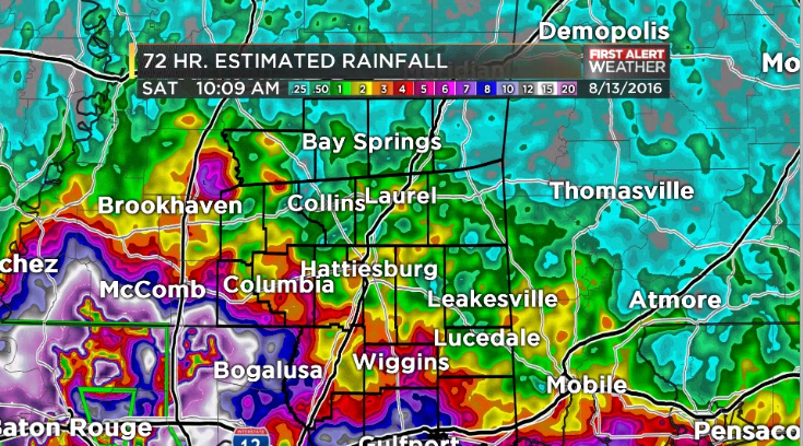
Some of the areas across the Pine Belt picked up a fair amount of rain Thursday, but it was pretty localized. Generally, about 0.5″ to 1.50″ of rain fell, but folks in Wiggins, Lumberton, Purvis, Columbia and points nearby picked up between 2.5″ and 4″ of rain.
The reason? Everything that happened Wednesday, was gone. We moistened up the atmosphere AND the amount of vertical motion in the atmosphere increased!
And if you look closely at the map, you’ll also notice that the areas that picked up the most rain in our area, happened to be in the spots with the most vertical motion under the highest relative humidity.
General Area Rain Total for Event: 1.0″ to 2.25″
Highest Localized Rain Total for Event: 5.5″
Friday, Friday… Gotta see rain on Friday
Now that the Rebecca Black song is stuck in your head again, let’s look at Friday.
Again, there was a situation where the most 700mb vertical motion was puched to the west, and therefore, most of the 500mb moisture was west, too. As was the area of low pressure.
And therefore! Most of the rain was to the west, too.
In fact, if you look at the graphics above, and line each one up, you’ll see that the heaviest rain fell on top of the places where the vertical motion was the greatest and the relative humidity was the highest.
And that makes sense! In places where you are taking the Gulf moisture and moving up – with vertical motion – the most, should be the area where the most rain then falls out.
But there was a secondary area of rainfall, Friday. It is on the map, but I’m standing in front of it. A few bands of rain move ashore in Alabama and Florida and gave them some rain, too. But that should also make sense. Because if you look back on those graphics, the vertical motion down stream from the storm motion was higher!
But again, for the Pine Belt, no dice. Most of the area picked up between .10″ and .75″ of rain. The heaviest rain fell in Marion County, but even they only picked up about 0.5″
General Area Rain Total for Event: 1.1″ to 3″
Highest Localized Rain Total for Event: 6″
Forecast… Verified?
I think so. We called for 1″ to 3″ of rain around the area with localized spots of 3″ to 5″ of additional rain. We called for very localized flooding, but no widespread flooding on Tuesday.
We ended up with 1″ to 3″ across the area – except our far NE counties who only saw 0.5″ total – with localized spots with 4″ to 8″ (or an additional 3″ to 5″).
Sadly, for our friends to our west in Louisiana, their meteorologists also got it right and the rain did not miss them.


