Invest 99L is still an “Invest” today, Thursday, August 25th, 2016. That marks Day Seven of models continuing to say that today is the day that it gets organized.
So far, though, the Invest hasn’t been interested in such things.
Here is a look at the area of low(er) pressure Thursday morning:
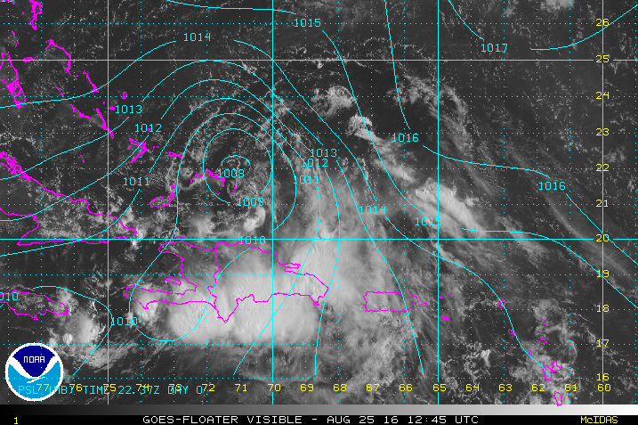
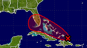
The National Hurricane Center continues to show this area has a 50-percent chance of tropical development during the next 48 hours and an 80-percent chance of development during the next five days.
From the NHC:
The National Hurricane Center is issuing advisories on recently
upgraded Hurricane Gaston, located about 1200 miles east of the
Leeward Island.1. An area of low pressure associated with a tropical wave is
centered just southeast of the Turks and Caicos Islands. The wave
is producing gale-force winds over water to the north of
Hispaniola, however, satellite images indicate that the shower and
thunderstorm activity is well removed from the area of lowest
pressure. Surface data also indicate that the low continues to
lack a well-defined center. Although upper-level winds are only
marginally conducive for development during the next day or so,
they are expected to become a little more favorable by the weekend,
and this system could become a tropical depression during the next
couple of days. An Air Force Reserve Hurricane Hunter aircraft is
scheduled to investigate the wave later this morning.Regardless of development, heavy rains are likely over Puerto Rico
today, and strong winds and heavy rainfall are likely over portions
of Hispaniola, the Turks and Caicos, and the southeastern and
central Bahamas during the next couple of days. These rains could
lead to flash floods and mudslides. Please consult products issued
by your local meteorological offices and High Seas Forecasts from
the National Weather Service for further details.Interests in the northwestern Bahamas and Florida should monitor the
progress of this disturbance since it is increasing likely that
some impacts, at a minimum heavy rains and gusty winds, will occur
beginning this weekend.
* Formation chance through 48 hours…medium…50 percent
* Formation chance through 5 days…high…80 percent
The NHC forecast track also falls between the BAMx model guidance.
Speaking of model guidance, the name should be changed with respect to this Invest. Perhaps “model guidance” should be renamed “model dart chucking” instead. The forecast strength, track, organization and almost every other parameter measurable have been a bit off for this storm.
It reminds me of Invest 96L from a few years ago. It also was unusually difficult to predict. And it also happened to be right around the end of August.
Anyway, because I know folks want to see it, here is the spaghetti plot for Invest 99L as of 12z, August 25th, 2016:
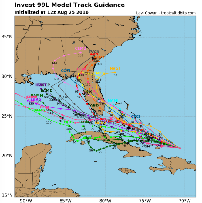
Don’t get too caught up in the above plot past about 48 hours, though. This storm has been quite tricky to forecast. Most of these models, also, through 48 hours keep this as a Tropical Depression or Tropical Storm only – Not a Hurricane.
Most meteorologists have dubbed this a High Impact / Low Confidence event. That means that what we know about the forecast is out-weighed (drastically) by the possible impacts it may have on people.


