Here are some snippets from the 11AM advisory from the National Hurricane Center:
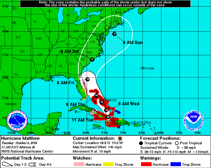
At 1100 AM EDT (1500 UTC), the eye of Hurricane Matthew was located in the Gulf of Gonave near latitude 18.9 North, longitude 74.3 West. Matthew is moving toward the north near 10 mph (17 km/h). On this track the eye of Matthew will move over the Windward Passage and eastern Cuba today. A turn toward the north-northwest is expected by Wednesday, followed by a northwest turn Wednesday night. Matthew is expected to move near or over portions of the southeastern and central Bahamas tonight and Wednesday, and approach the northwestern Bahamas Wednesday night.
Maximum sustained winds remain near 145 mph (230 km/h) with higher gusts. Matthew is a category 4 hurricane on the Saffir-Simpson Hurricane Wind Scale. Some fluctuations in intensity are possible during the next couple of days, but Matthew is expected to remain a powerful hurricane through at least Wednesday night.
Hurricane-force winds extend outward up to 60 miles (95 km) from the center and tropical-storm-force winds extend outward up to 185 miles (295 km).
The estimated minimum central pressure is 950 mb (28.06 inches).
Watches & Warnings
A Hurricane Watch is in effect from Deerfield Beach, Florida to
the Volusia/Brevard county line.A Tropical Storm Watch is in effect from the Seven Mile Bridge in the Florida Keys northward to south of Deerfield Beach, including Lake Okeechobee
The government of Jamaica has discontinued the Tropical Storm Warning for Jamaica.
SUMMARY OF WATCHES AND WARNINGS IN EFFECT:
A Hurricane Warning is in effect for…
* Haiti
* Cuban provinces of Guantanamo, Santiago de Cuba, Holguin, Granma, and Las Tunas
* Southeastern Bahamas, including the Inaguas, Mayaguana, Acklins, Crooked Island, Long Cay, and Ragged Island
* Central Bahamas, including Long Island, Exuma, Rum Cay, San Salvador, and Cat Island
* Northwestern Bahamas, including the Abacos, Andros Island, Berry Islands, Bimini, Eleuthera, Grand Bahama Island, and New ProvidenceA Hurricane Watch is in effect for…
* Cuban province of Camaguey
* Deerfield Beach to the Volusia/Brevard county lineA Tropical Storm Warning is in effect for…
* Dominican Republic from Barahona westward to the border with Haiti
* Turks and Caicos IslandsA Tropical Storm Watch is in effect for…
* Dominican Republic from Puerto Plata westward to the border with Haiti
* Seven Mile Bridge to south of Deerfield Beach
* Lake OkeechobeeA Hurricane Watch means that hurricane conditions are possible within the watch area. A watch is typically issued 48 hours before the anticipated first occurrence of tropical-storm-force winds, conditions that make outside preparations difficult or dangerous.
A Tropical Storm Watch means that tropical storm conditions are possible within the watch area, generally within 48 hours.
Interests elsewhere in Hispaniola and in the Florida Peninsula and the Florida Keys should monitor the progress of Matthew.
For storm information specific to your area in the United States, including possible inland watches and warnings, please monitor products issued by your local National Weather Service forecast office. For storm information specific to your area outside the United States, please monitor products issued by your national meteorological service.
The next advisory will be out at 2PM eastern time.


