Good evening, everyone! Here is a quick update from the HRRR model and a quick discussion abotu what to expect.
EDIT: I’m writing this while in the car as a passenger, so if Im a bit scatter-brained I apologize. I’ll try my best to keep this on track.
Okay, here we go!
First things first, what does the HRRR think the radar will look like:
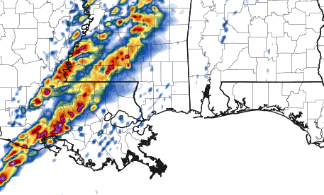
The HRRR keeps most of the showers and storms out of our area until around midnight. While we could see a few isolated showers and storms before that point, most of those will be instability showers and will be below severe limits.
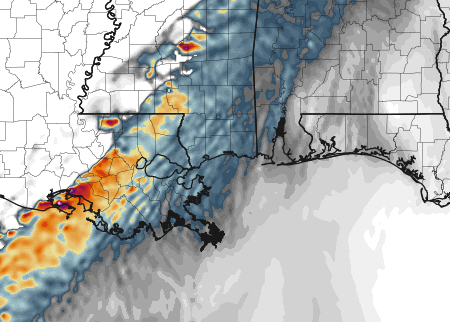
Once the line of storms (above) moves into the area, any storms that develop directly in front of the line and embedded within the line will have the ability to turn tornadic. I think that an EF4 or EF5 tornado is unlikely as the atmosphere in our area isn’t quite as primed as our friends to the north but an isolated EF1 or EF2 tornado is possible. An EF3 isn’t out of the question, but it isn’t likely by any means, either.
The good news? The 700mb to 500mb Lapse Rates aren’t bad overnight – in the 5.8 to 6.9 range. What does that mean? That the instability will be held in check (a bit) and could keep storms from REALLY getting going out ahead of the line.
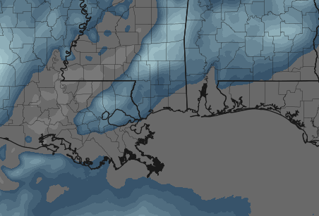
You can see the HRRR model showing the lack of strong rotating updrafts with the updraft helicity map here. Since the Lapse Rates aren’t as stout, it is tough to get fast-moving rotating updrafts. And storms need a rotating updraft to turn supercellular. And you need a rotating updraft for a tornado, too.
So with only a few spots showing rotating updrafts, it means we will have a few chances for rotation storms and the possibility of tornadoes. But this is also why I think strong, devastating, extremely violent tornadoes are unlikely because the bright colors on this map just aren’t there.
And before you start picking out where these are on the map and saying “no updraft helicity near me, so no tornado! Im safe” or even before you think “There ain’t much there, I’m A-OK!”
Sadly, these models struggle to forecast specifics like individual storms and tornadoes (that’s why when you ask “will there be a tornado in my town?” we can’t tell you). What we can do with this is take a peek at this and say, okay no bright colors near us so we shouldn’t have to worry about strong tornadoes. But EF0, EF1, EF2 and maybe even an EF3 tornado is possible.
So… What’s the Deal?
So, how bad will it be? Not a knock-down, drag out, widespread tornado outbreak like our friends to the north. But you do need to keep an eye on the weather tonight. I’m more concerned about strong straight-line, non-tornadic wind associated with that line of storms as it pushes through. Gusts could approach 75mph in that line. And even without a tornado, a 75mph wind can still do plenty of damage.
Timing?
Starting as early as 9pm for our western counties and lasts as late as 6am in our eastern counties. This is going to be an overnight event. Please have you NOAA Weather Radio handy.


