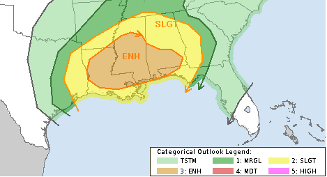
Most of the southern sections of Louisiana, Mississippi and Alabama are under an Enhanced Risk for severe weather, including a 5% Tornado risk.
Here is the latest from the SPC:
Low-level moistening is already underway with middle 60s surface dew
points expected across much of Louisiana and the southern halves of
Mississippi, Alabama, and Georgia by early afternoon. This combined
with pockets of surface heating and a plume of steep midlevel lapse
rates (at least 7 c/km in the 500-700 mb layer) spreading across the
lower Mississippi Valley to western Alabama will boost instability
to moderate values (1000-1500 j/kg) across the Enhanced risk area.Ongoing showers and thunderstorms across the western Florida
Panhandle through southern Alabama to central Georgia appear to be
attendant to a midlevel impulse currently tracking across this
region. This impulse should reach central Georgia by 12Z today,
with the potential for some breaks in the cloudiness across the warm
sector of southern Alabama and the Florida Panhandle to southeast
Mississippi and southeast Louisiana through the morning to early
afternoon.An ongoing band of strong to severe storms is expected across parts
of East Texas at 12Z today with this band advancing east into a
destabilizing warm sector across the lower Mississippi Valley
through this morning and afternoon, while deep-layer wind fields
strengthen and spread east with the trough. Deep-layer shear will
be sufficient for an organized severe storm threat as activity
spreads east and northeast, with all severe hazards possible. Given
a 50 kt southwesterly 700-mb jet spreading across southern
Louisiana to southern Alabama this afternoon and evening, this
region may have the greatest coverage of severe storms with damaging
winds being the primary threat.A separate area of strong to severe storms should develop across the
central Gulf coast across southeast Louisiana into southwest Alabama
attendant to a separate midlevel impulse, currently moving across
Deep South Texas. Vertically veering and strengthening winds will
favor all severe hazards with this activity as it spreads into the
western Florida Panhandle, southern and perhaps central Alabama to
parts of western Georgia.Farther north into Tennessee and southwest Kentucky, instability
should be elevated with isolated hail being the primary threat with
storms across these areas.


