Good morning, everyone. Here is a brief breakdown of where we are…
Timing
Louisiana’s round one is moving through western Louisiana. Mississippi’s round one is moving through the Pine Belt. Alabama’s round one is moving through SW Alabama.
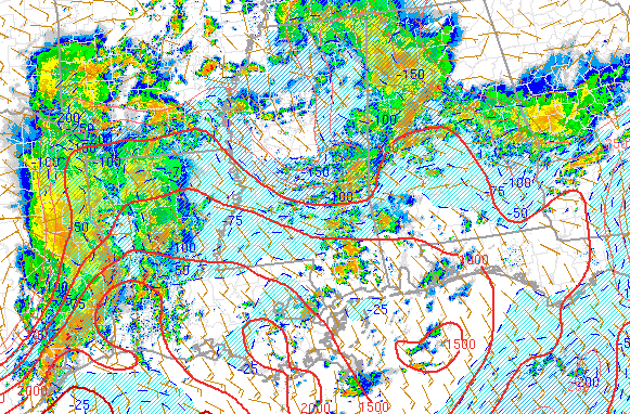
Things are, for the most part, right on track. The first rounds of storms for Mississippi and Alabama have been below severe limits and the line of storms in Louisiana have included multiple severe storm warnings.
As we head through the rest of the day, the line of storms in Western Louisiana will race across the state, into Mississippi by 1pm and into Alabama by 6pm. As it moves through heavy rain, strong wind, small hail and an isolated tornado will be possible.
Ahead of that line, isolated storms (like the ones in Mississippi this morning) will be possible. These storms have the potential of being severe, too. And these storms will likely have the highest threat to produce a tornado. So, like I always say, try not to focus only on the line of storms, but also on the individual storms ahead of the line.
Below are the suggested radar data from the HRRR computer weather model. Find yourself on the map and take a look at the time and you should get a general idea of when the line will move through.
As for the timing of the individual storms ahead of that line… That is anyone’s guess. Our computer weather models are good, but not great at figuring out where individual storms will develop. So treat every storm and every rumble of thunder like it is the real deal (a severe storm) until you figure out otherwise.
Risk
As for the overall risk for today, it is real.
The SPC has the area under an Enhanced Risk for severe weather. That is a 3 out of 5 on the SPC’s five-tier rank. There is a broad area of a 5% tornado risk with a pill-sized 10% risk along the Gulf coast of the three states.
And while 5% and 10% may not sound like much, keep in mind that your risk for seeing a tornado is 0% on a sunny day. So you are 5 to 10 times more likely to see a tornado today than any regular day.
I always try to think of the tornado percentages like multipliers in video games. Or the lottery. Instead of seeing 2%, 5%, 10% or 15% I see 2x 5x 10x 15x.
SPC
Here is the latest from the Storm Prediction Center:
A progressive shortwave trough over central TX this morning will
steadily spread eastward, reaching the lower MS River Valley by
early evening and the southern Appalachians vicinity by early
Tuesday. A related strengthening of low/mid-level winds will occur
ahead of this eastward-advancing impulse, particularly across east
TX and LA/MS early today, and across AL/GA and the FL Panhandle this
afternoon and tonight. As this occurs, an increasingly moist
boundary layer will exist across a broad portion of the region to
the south of a warm front that will continue to move slowly
northward across parts of the Mid-South and toward the TN River
Valley, although ongoing early-day convection across MS/AL may
effectively regulate the corridor of peak diurnal destabilization
this afternoon.Initially, a band of fast-moving storms with a history of
severe-caliber wind gusts across central Texas overnight are ongoing
(13Z) across much of east Texas, including an uptick in a somewhat
separate band of storms across southeast Texas over the past few
hours. A mixed convective mode will likely become increasing
prevalent into the late morning/midday hours as the aforementioned
linear convection races into LA and southern AR with a damaging wind
risk, with the possibility of line-preceding semi-discrete
storms/supercells (capable of a tornado risk) also increasing as the
boundary layer warms/destabilizes during the day.Farther east, to the south of early-day showers/thunderstorms across
central portions of MS/AL, additional storms should also increase
this afternoon/early evening across southeast LA into the southern
thirds of MS/AL. Strengthening/backing of mid-level winds would
suggest a mixed convective mode across this corridor, but
increasingly large low-level hodographs should yield a tornado risk,
potentially semi-focused near/south of what may be an
outflow/differential heating-related effective warm front.


