As we look toward the weekend an area of low pressure, with a batch of cold air aloft will slide from New Mexico and west Texas across the southeast. It will open the door for showers and storms – some severe – to develop across Louisiana, Mississippi, Alabama, the Florida Panhandle, and Tennessee.
The Storm Prediction Center is keeping a close eye on this.
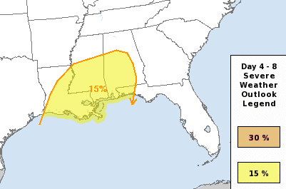
From the SPC:
…DISCUSSION…
…Saturday and Sunday across the Southeast States…
A seasonably strong mid-upper jet and associated shortwave trough
are forecast to progress eastward to TX by Saturday night, and then
continue eastward to the Southeast States by late Sunday. An
initial lee cyclone across the southern High Plains on Saturday will
develop eastward to the TN Valley and deepen by Sunday, as an
associated surface cold front surges eastward across the Gulf coast
and then across FL and off the Southeast Atlantic coast by the end
of day 5 (early Monday). A broad corridor of low-level moisture
return will be maintained across the Gulf coast through Sunday, as
well as a feed of relatively steep midlevel lapse rates from the
west-southwest. The synoptic pattern evolution and thermodynamic
environment, in general, appear supportive of severe storms, some of
which could be significant.Several episodes of severe storms will be possible with the
potential for ongoing convection Saturday morning with a lead
shortwave trough and warm advection, and additional storm
development through Sunday in association with the primary synoptic
wave/cold front. The influences of the lead waves and associated
convection on the low-level mass response and later convection, as
well as resultant low-level shear, are still in question. There
will likely be some mesoscale modulations to the risk areas and
storms types, including the northward extent of the unstable warm
sector. Given these typical uncertainties, will maintain broad 15%
areas for both Saturday/day 4 and Sunday/day 5, and monitor closely
for more significant severe potential as important details emerge
(especially Sunday/day 5).


