As if the January 21st event wasn’t enough, Mother Nature is preparing to send another round of storms through south Mississippi. Thankfully, this time doesn’t look as bad.
The Setup
As an area of low pressure moves out of the Rockies and into the Plains, there is a bit of divergence in the models on the evolution of the system. Generally, model guidance takes from from Montana and through Wisconsin.
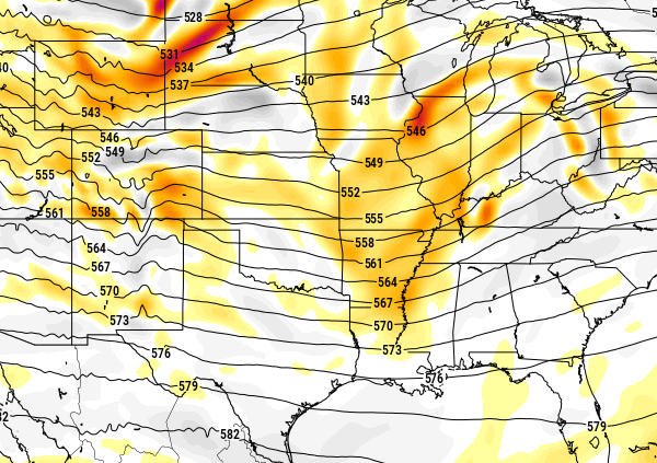
As it does so, a piece of vorticity (energy) at 500mb on the fringes of that system will be flung through parts of the Ohio River Valley and sections of the Mississippi River valley.
And at the same time as that, a cold front will be pushing south through Mississippi.
The question is how far south will that vorticity stretch, and will it be lined up with the cold front, as both will be the catalyst for storm development.
At the surface and in the mid-levels of the atmosphere, there will be ample instability and shear for any storm to work with. Mixed-layer CAPE values are between 800 and 1400 J/Kg depending on which model you look at. 3Km and 6Km shear values are running between 40 and 60kts. And mixed-layer LCL values are down between 600 and 800 meters.
All of those values are favorable for the development of severe weather.
Right now the only limiting factor within the models is a slight cap of warm air.
The Breakdown
When looking at the individual parameters, this event isn’t overwhelmingly severe-looking. The Karrie Meter is still kicking out values around 3.75 for south Mississippi. That means we are looking at a Marginal or Slight Risk from the Storm Prediction Center.
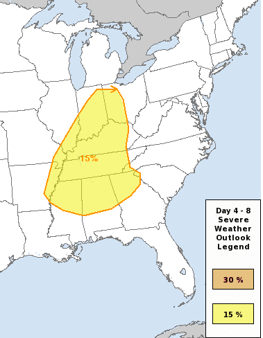
And in fact, the SPC has already highlighted areas to our north (Tennessee, Kentucky, Indiana, Ohio and northern sections Mississippi, Alabama and Georgia) with a 15% Risk. That will likely translate to a Slight risk tomorrow – with a bulls-eye of Enhanced Risk, too – for those areas.
The reason we aren’t included is likely due to the uncertainty of how far south that energy makes it. As well as if there is enough ‘umph’ to get storms off the ground (and through that cap of warm air).
But a wide swatch of Marginal Risk is likely to extend from nearly the Gulf Coast to the just about Great Lakes. Not because this system is going to be a big tornado-maker or incredibly severe, but that the available energy at 500mb will be widespread.
Looking at the CIPS Analogs from Saint Louis University, they have been pointing to a setup that is favorable for the development of severe weather mainly in Tennessee and Kentucky. Showing, historically, only a few rogue storms in Mississippi in this kind of situation.
So this next storm system is not – repeating: NOT! – like the January 21st storm system. The setup is different, the breakdown is different, basically the only thing the two have in common is each Low pressure.
The Timing
The thinking right now is that there will be isolated storms south of I-20 on Tuesday night after 5pm. They may become a bit more widespread, but generally the severe storms will likely be few and far between. The chance for a tornado will likely be between 6pm and 10pm. By 2am, things should calm down.
The only caveat to that is our weather balloons haven’t started collecting data from the next storm system yet because it is still off the coast of Oregon and Washington. Once the balloons start to sample this system, the timing will likely change as more data is ingested into the models.
The Problem
There is a chance that the front that is supposed to push through may linger around on Wednesday giving some areas a second chance for storms. Depending on how Tuesday shakes out, Wednesday may not be as bad. But it is something we are paying close attention to.


