Forecast update on Slight Risk for South Mississippi
Author: Nick Lilja
|| Published: 2/7/2017 at 12:38am
Good (late) evening, everyone. There is still the opportunity for severe weather tomorrow for south Mississippi. A few things have changed, but the timing remains about the same.
Changes
Some threats have remained the same, but some have increased. Here is the update…
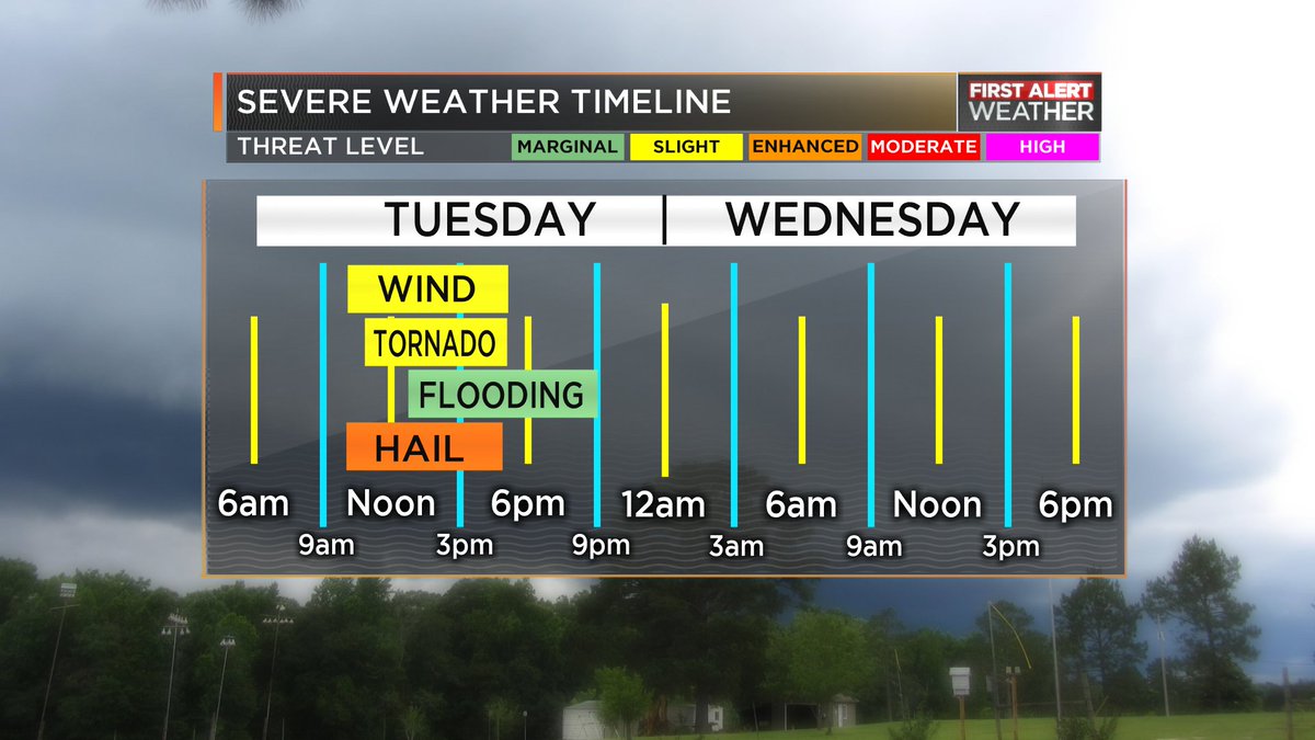
Severe Weather Timeline
Heavy rain, some small stream and street flooding is still possible. No real change here.
Frequent lightning is likely. No change here.
Damaging wind is still possible in storms that develop. Wind speeds up to 65mph in some storms may topple trees, knock over fences and damage roofs. No real change here.
Hailstones up to the size of golf balls will be possible. This is a change. Originally, quarter to ping pong sized hail seemed like the biggest hail, but now golf ball sized hail cannot be ruled out in the strongest storms.
Tornadoes are possible, but they will be few and far between. If a storm is able to get rooted, stay discrete and tap into the available atmospheric energy, an EF-2 or EF-3 cannot be ruled out. BUT! That will take a very particular set of things to happen in a particular series, so it isn’t likely. But it is possible. Generally EF-0 or EF-1 tornadoes, if any at all develop, will be generally the limit on strength. Those strength tornadoes will do the same type of damage as straight-line wind, but with a twisted aspect added, watch out for more roof damage and siding damage, too.
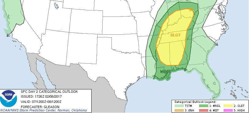
Day 2 SPC Risk as issued February 6, 2017
Overall, I wouldn’t be surprised to see the Slight Risk from the SPC extended south and back west of the current area when the next update is released at midnight.
Timing
I wrote in an earlier post that between 11a and 2p was the most likely time for bad weather. I think that still stands…. But that is going to come with a caveat.
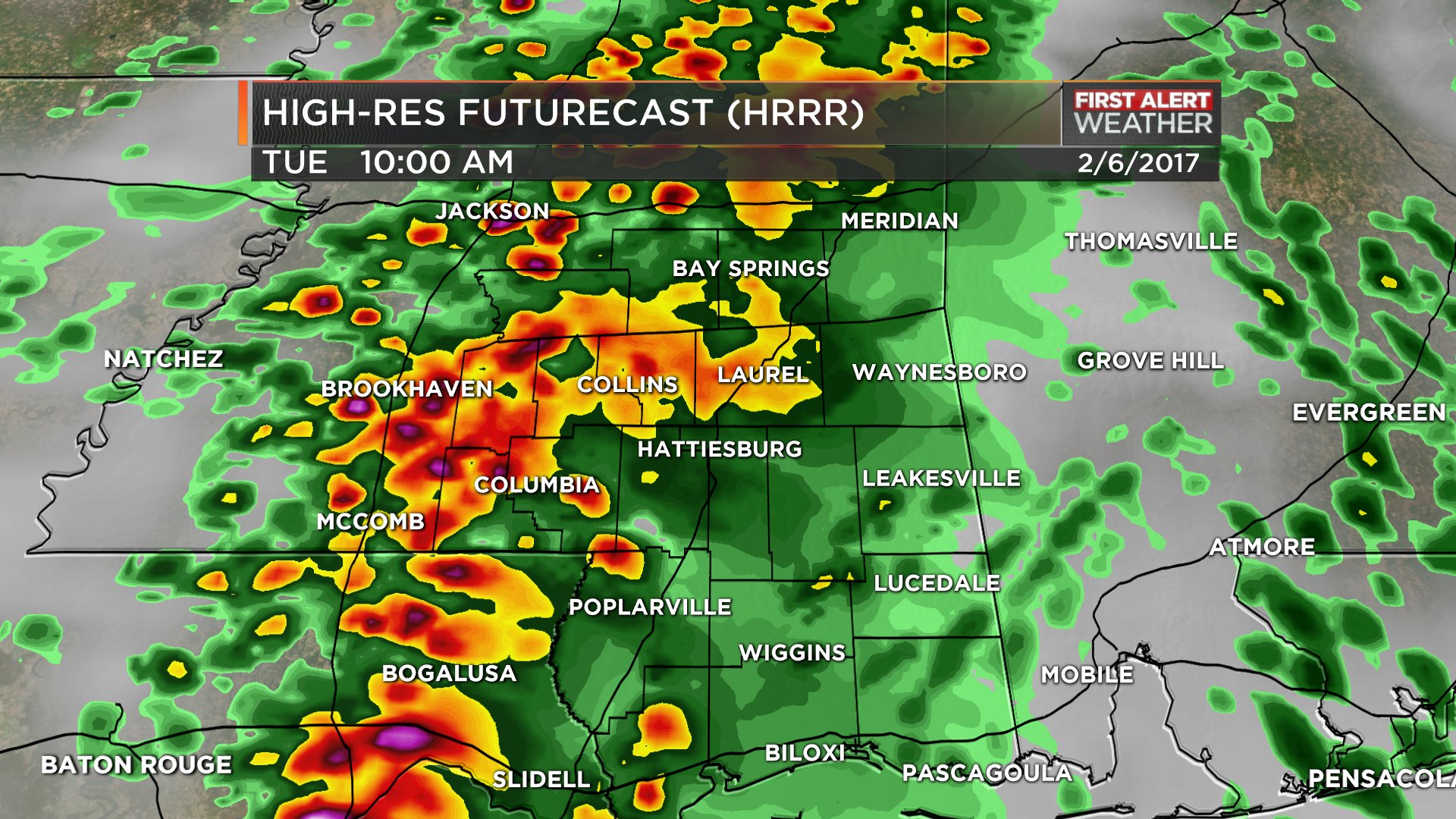
3KM HRRR simulated reflectivity // courtesy James Spann’s Twitter account
For Mississippi south of I-20, I think first storms move into Pike, Lincoln, and Copiah counties – as well as the Parishes of Louisiana – around 10am and enter Walthall, Lawrence and Simpson counties by 11am.
Then move across the area from West to East. Some may even have a WSW to ENE track.
Storms will reach the I-59 corridor by noon. Then exit into Alabama by 2pm.
This is only the first storms, I think we may see a few linger around through 5pm here and there. But the sever threat will be greatest with the first wave of storms around noon.
Storm movement looks to be WSW to ENE with a few edging more SW to NE.
Also, coverage will be much more widespread. Originally, we were thinking just a few storms here and there, but it now looks like a handful of storms across the area will make the lunch hour a bit soggy for everyone.
Due to that the Karrie Meter has been updated.
Looking at individual parameters from the latest (as of the time of this writing) RAP data from Pivotal Weather, the 4z RAP kicked out this profile for the Pine Belt.
This is why hail is becoming a bigger threat. Freezing temperatures will be possible as low as 700mb with temperatures at 500mb near -20C.
The tornado threat is increasing, too as low LCLs and strong downdraft CAPE will be available to any storm able to stay discrete.
Author of the article:
Nick Lilja
Nick is former television meteorologist with stints in Amarillo and Hattiesburg. During his time in Hattiesburg, he was also an adjunct professor at the University of Southern Mississippi. He is a graduate of both Oregon State and Syracuse University that now calls Houston home. Now that he is retired from TV, he maintains this blog in his spare time.