As a deepening area of low pressure moves by from Texas to Tennessee, it will open the atmosphere aloft leading to showers and storms across eastern Texas, Louisiana, Mississippi and Alabama. This discussion is specifically for south Mississippi.
From the SPC
UPDATE 9:30 PM 4/2/17: The SPC has put south Mississippi back under an Enhanced Risk
DISCUSSION…While northern portions of the watch have stabilized owing to earlier convection and ongoing precipitation, MLCAPE over 1000 J/kg (e.g., 00 UTC LIX sounding) remains in place across the warm sector over southeastern Louisiana and southern Mississippi. Discrete storms developing in the warm sector ahead of the main QLCS will pose the greatest threat for tornadoes and large hail over the next few hours.
With time, the quasi-stationary QLCS extending southwest-northeast across central Louisiana and Mississippi is expected to assume a more meridional orientation, as the shortwave approaching from the west rotates through the base of the main trough. Consequently, damaging winds from an eastward-propagating MCS will likely become the primary severe weather threat by 05-06Z, though embedded circulations in the line will still pose a tornado risk.
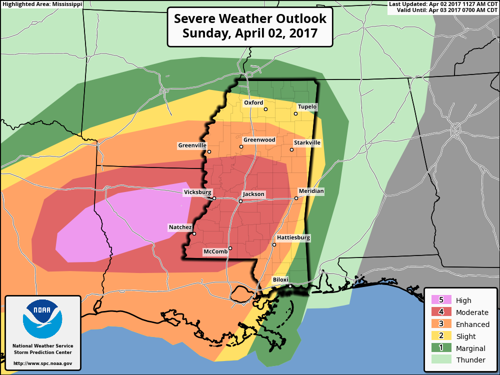
FROM 12:30pm 4/2/17: The SPC has upgraded our area to a Moderate Risk for severe weather.
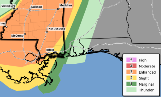
Originally, as of 10:45am, this is how the map looked.
Timeline
I won’t get into the nitty-gritty details here, instead this is just an idea about when to expect what. This is subject to change in the afternoon as more data comes in, but right now, this is the latest forecast for areas in Mississippi south of I-20 and east of I-55 this what we are looking at:
11pm – 3am | Instability showers and isolated storms will be possible to develop ahead of the main line. Storms should remain sub-severe, most won’t even be strong storms. That said, if any storm is able to develop, get rooted, and break through the cap of warm air, it would have the potential to turn severe.
3am – 5am | Isolated showers and storms begin to develop in Walthall, Lawrence and Simpson counties. Storms will be moving northeast at 30 to 50mph. Most of these will be sub-severe, but a few will be severe with the threat for heavy rain, damaging wind (more than 65mph), frequent lightning, hail (up to the size of half-dollars) and a tornado can’t be ruled out.
4am – 6am | Isolated storms begin to push into Marion, Jeff Davis, and Smith counties. The main threat with these storms will continue to be heavy rain, damaging wind (more than 65mph), frequent lightning, hail (up to the size of half-dollars) and a tornado can’t be ruled out. Behind the isolated storms, the main squall-line may start to break apart at this time as it enters Walthall, Lawrence and Simpson counties. The main threats with the squall-line will be heavy rain, damaging wind (up to 75mph), a ton of lightning, hail up the size of golf balls. Within the line, we also need to watch for embedded, rain-wrapped tornadoes.
5am – 7am | Isolated storms being to develop in Pearl River, Stone, Lamar, Forrest, Jones and Jasper counties. The main concerns will still be heavy rain, damaging wind (more than 65mph), frequent lightning, hail (up to the size of half-dollars) and a tornado can’t be ruled out. Behind the isolated storms, the main squall-line (a bit broken, perhaps) starts to enter Marion, Jeff Davis, and Smith counties. The main threats with the squall-line will be heavy rain, damaging wind (up to 75mph), a ton of lightning, hail up the size of golf balls. Within the line, we also need to watch for embedded, rain-wrapped tornadoes.
Walthall, Lawrence and Simpson counties will begin to see improving conditions, but storms will still be in the area.
It is at this time that the atmosphere – generally – stabilizes a little. However, given the massive amount of CAPE it won’t do much to diminish the overall severe weather threat.
The tornado threat, due the the amount of instability, shear and helicity will be – generally – higher during this time, too. So please have a Severe Weather Plan, a NOAA Weather Radio, Weather app on your phone as well as shoes near you and a way to receive updates on storms from your safe place.
6am – 8am | Isolated storms being to develop in Clarke, Wayne, Perry, Greene, and George counties. The main concerns in these counties will still be heavy rain, damaging wind (more than 65mph), frequent lightning, hail (up to the size of half-dollars) and a tornado can’t be ruled out. Behind the storms, the squall-line will begin to enter Pearl River, Stone, Lamar, Forrest, Jones and Jasper counties. The main threats with the squall-line will be heavy rain, damaging wind (up to 75mph), a ton of lightning, hail up the size of golf balls. Within the line, we also need to watch for embedded, rain-wrapped tornadoes.
Marion, Jeff Davis, and Smith counties will begin to see improving conditions, but storms will still be in the area.
Walthall, Lawrence and Simpson counties should start to clear out at this time.
7am – 9am | The squall-line will begin to enter Clarke, Wayne, Perry, Greene, and George counties. The main threats with the squall-line will be heavy rain, damaging wind (up to 75mph), a ton of lightning, hail up the size of golf balls. Within the line, we also need to watch for embedded, rain-wrapped tornadoes.
Pearl River, Stone, Lamar, Forrest, Jones and Jasper counties will begin to see improving conditions, but storms will still be in the area.
Marion, Jeff Davis, and Smith counties should start to clear out at this time.
8am – 10am | Clarke, Wayne, Perry, Greene, and George counties will begin to see improving conditions, but storms will still be in the area.
Pearl River, Stone, Lamar, Forrest, Jones and Jasper counties should start to clear out at this time.
Walthall, Lawrence Simpson, Marion, Jeff Davis, and Smith counties should get the “All Clear” by this point.
9am – 11am | Storms push into Alabama, clearing skies into the afternoon.
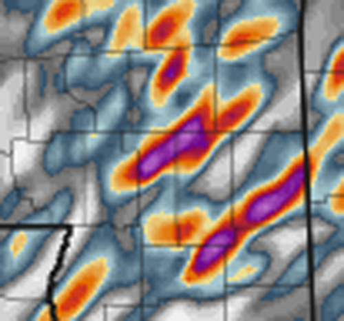
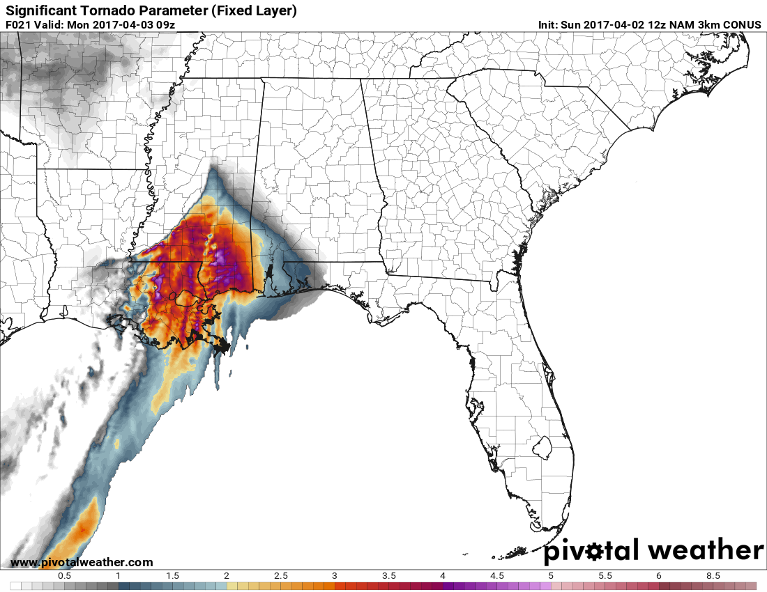
The Strike Zone for Updraft Helicity
This sounds more ominous than it should, but I wanted to highlight some of the areas I think have the biggest threat to see the strongest storms. This doesn’t guarantee severe weather in these areas, nor does it mean if you don’t live in these areas that you are in the clear.
This is just a look at the areas where parameters are going to overlap a bit better and where updraft helicity is going to be at it’s highest.