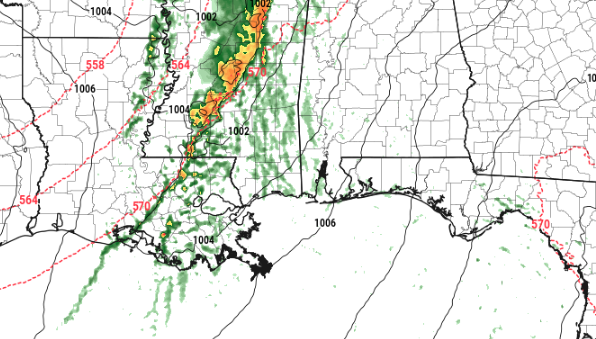
As a cold front moves through Mississippi, there will be sufficient forcing and instability to promote the development of thunderstorms Thursday morning before sunrise.
Right now, it appears that heavy rain, frequent lightning, damaging wind and hail will be the main concerns. Although, a tornado cannot be ruled out.
From the SPC:
…Arklatex/Lower to Mid Mississippi Valley…
An upper-level trough is forecast to move across the Great Plains on Wednesday as a cold front advances eastward across the Ozarks and Arklatex. Convection is forecast to develop along and behind the front during the morning across eastern Kansas and western Missouri. Thunderstorms are forecast to gradually expand in coverage, moving eastward across Missouri and Arkansas during the afternoon. The development of a linear MCS appears to be a possibility as the front moves into the lower to mid Mississippi Valley Wednesday evening.
Ahead of the front, strong moisture advection will increase surface dewpoints into the mid to upper 60s F from northern Louisiana northward into southeast Missouri where a corridor of moderate instability should be in place by afternoon. This combined with 60 to 65 kt of deep-layer shear evident on forecast soundings, should support a severe threat. The greatest potential for large hail and possibly a tornado or two, will be associated with supercells early in the event. However, storms may have trouble remaining discrete due to a synoptic-scale band of large-scale ascent associated with the approaching upper-level trough and due to strong low-level convergence along the front. For this reason, the greatest severe threat coverage could associated with damaging wind gusts.
…Thursday/Day 4…
The medium-range models show a cyclonic flow regime from the southern states into the east-central states on Thursday/Day 4. A cold front is forecast to be located from east-central Texas extending east-northeastward across the Gulf Coast states and into the southern Appalachian Mountains by afternoon. An isolated severe threat will be possible during the afternoon along parts of the front that destabilize sufficiently. The spatial distribution of any severe threat remains uncertain at this time.
Timeline
Storms will being to move into Simpson, Lawrence and Jeff Davis counties as early as 2am. And linger as late as 10am in Greene and George counties.