The Tropical Disturbance, now Invest 93L, we have been watching for the last five to seven days is finally starting to get its act together.
Sort of.
During the last few days, it will have hours of organization, followed by hours of disorganization. It can’t seem to make up its mind.
And there is a reason, really. And I’ll borrow some phrasing from “Rex Kwon Do” to explain.
First off, it is early in the season, water temperatures are not as balmy as they would be in, say, August.
Second off, wind shear, while not extraordinarily stout, is present. And that shear is doing a good job at keeping the storm semi-one-sided.
Last off, there is some land interaction it is battling, too, with the center so close to the hills of the Yucatan.
So what are the models saying?
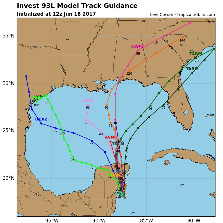
Beyond two or three days, they’re at a loss. Since it doesn’t have a true center yet, the models are struggling to resolve the outcome beyond 48 to 72 hours.
This is normal.
Once it finally forms, and we get a real center, then the forecasts will improve dramatically.
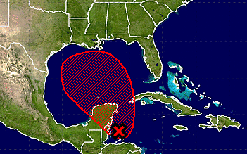
The latest forecast from the National Hurricane Center:
A broad area of low pressure located over the northwestern Caribbean Sea continues to produce a large area of disorganized showers and thunderstorms. Gradual development of this system is expected while it moves slowly northwestward across the Yucatan Peninsula later today and over the southern or central Gulf of Mexico on Monday and Tuesday, where a tropical or subtropical cyclone is likely to form. Regardless of development, heavy rains are expected over portions of Central America, the Yucatan Peninsula, Jamaica, the Cayman Islands, and western Cuba during the next several days. An Air Force Reserve Hurricane Hunter aircraft is scheduled to investigate this system later today, if necessary.
* Formation chance through 48 hours…medium…60 percent.
* Formation chance through 5 days…high…90 percent.
Excerpt from the Tropical Weather Discussion from the National Hurricane Center:
A 1007 mb low pressure center is about 45 nm to the east of the northern part of the coast of Belize, near 17.5N87W. Numerous strong rainshowers cover the area that is from 13N to 20N between 81W and 85W, in the coastal waters of Nicaragua and Honduras. Widely scattered moderate to isolated strong rainshowers also cover the area from 15N to the southern coast of Cuba between 77W and 82W. This low pressure center is forecast to move slowly northwestward across the Yucatan Peninsula on Sunday, and into the southern or central Gulf of Mexico early next week. It is likely that a subtropical or tropical cyclone may form. Heavy rains are expected in parts of Central America, the Yucatan Peninsula, Jamaica, the Cayman Islands, and western Cuba during the next several days. An Air Force Reserve Hurricane Hunter aircraft is scheduled to investigate this system on Sunday, if necessary. The chance of formation into a tropical cyclone during the next two days is medium. Please read the latest NHC Tropical Weather Outlook under AWIPS/WMO headers MIATWOAT/ABNT20 KNHC for more details.


