Forecast for Potential Tropical Cyclone Three (formerly, Invest93L) shows rain, with some surge as main concerns
Author: Nick Lilja
|| Published: 6/20/2017 at 12:28am
Long title, I know. But the title spells it out pretty clearly. This isn’t going to be a massive hurricane with crazy wind and incredible damage.
It will be one that has a lot of rain and some coastal impacts from storm surge.
This discussion will focus primarily on southern Louisiana, southern Mississippi and southern Alabama. It will be broken down into categories so you can easily find the information you need and move on…
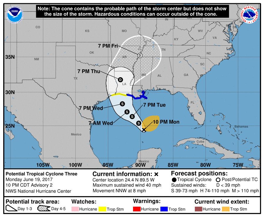
The Latest Forecast from the National Hurricane Center
6/19/17 10PM Advisory from the National Hurricane Center
Earlier this afternoon, an Air Force Reserve reconnaissance aircraft investigating the central Gulf of Mexico disturbance found that the multiple swirls that this system possessed had consolidated into a single low-level circulation center with a pressure of about 1000 mb. However, since the circulation was and still is elongated north-to-south, the large low pressure system is being maintained as a potential tropical cyclone for this advisory cycle.The NWS now has the option to issue advisories, watches, and warnings for disturbances that are not yet a tropical cyclone, but which pose the threat of bringing tropical storm or hurricane conditions to land areas within 48 hours. Under previous policy this was not possible. These systems are known as Potential Tropical Cyclones in advisory products and are numbered from the same list as depressions. Because of the threat to the central Gulf coast, advisories have been initiated on Potential Tropical Cyclone Three and the appropriate watches/warnings have been issued. Users should be aware that forecast uncertainty for disturbances is generally larger than for tropical cyclones, especially beyond 48-72 hours.
After stalling this afternoon due to re-organization of the system’s center, the low now appears to be moving 330/07 kt based on recent conventional and microwave satellite fixes. The new forecast track has been shifted to the west of the previous advisory track through 48 hours, mainly due to the more westward initial position. Otherwise, no other significant changes were made to the previous forecast track. The low is expected to move generally northwestward through 48 hours around the southwestern portion of a deep-layer ridge located over the western Atlantic and Florida. After that, the system is forecast to turn northward around the ridge axis, moving into the south-central United States. The new NHC track forecast is a little to the right of the consensus model TVCA. Given the still disorganized nature of the circulation, and the fact that the wind and rain hazards extend well north and east of the center, users are encouraged to not focus on the details of the track forecast.
The initial intensity remains 35 kt based on reconnaissance wind data and observations from nearby ships 3ETA7 and 3FZO8. Only slight strengthening is expected for the next 36 hours or so due to moderate to strong southwesterly vertical wind shear of 25-30 kt. By 48 hours, the shear is forecast to decrease to 20 kt or less, but the system will already be close to land at that time and probably not be able to take advantage of the lower shear conditions. The NHC intensity forecast is similar to the previous advisory and the intensity consensus model IVCN.
The primary hazard from this disturbance is expected to be heavy rainfall over portions of the central and eastern Gulf Coast.
Most computer weather models suggest the heaviest rain will fall between New Orleans, Louisiana and Pensacola, Florida. Right now, determining where the heaviest rain will be is still a bit outside the abilities of our science. However, you can see that between the five computer weather models shown, there seems to be a consensus that the heaviest rain will fall between Slidell, Louisiana and Pascagoula, Mississippi.
Rainfall totals will run between 3″ and 6″ across the region. With a few spots receiving as much as 9″ of rain. And perhaps even a few spots eclipsing 12″ of rain!
Personal rainfall estimate concerns: These things can occasionally play out like the models suggest, but there are times when they whiff, too. My fear is they are going to whiff when it comes to rainfall totals.
I’ve found that with tropical systems there is always a stripe of much-higher-than-everyone-else rainfall. Determining specifically where that will be is next to impossible. Particularly this far out. So please – Please! – keep checking back with a trusted source of weather information (hopefully that’s us!) to follow where the heaviest rain may fall. We know more each day and can sharpen the forecast every few hours.
I can hear the question now, though… “Can’t you just estimate? C’mon, just take an educated guess… we won’t hold you to it”
I could, but it would be irresponsible. I don’t want anyone between Lake Charles, Louisiana and Panama City, Florida to think they are in any less danger of flooding than anyone else. Because at this point, everyone between those two spots is fair game for a good amount of water.
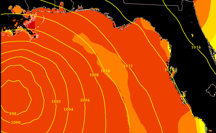
The Surge!
I will never profess to be someone who knows a lot about the physics of storm surge. I leave this one to the experts. What I can tell you is that while this storm won’t be terribly potent, the threat for surge is still very real.
ESTOFS Storm Surge Model Guidance
Latest model guidance / forecast information available suggests that that the Mississippi coast will deal with the worst of the storm surge.
Places like Bay St. Louis, Waveland, Diamondhead, and Pass Christian around the St Louis Bay could see up to two or three feet of water above ground level. Not above sea level, but above ground level.
According to the ESTOFS Storm Surge Model Guidance, Tuesday morning through Tuesday evening should offer the highest surge.
When does it all start?
Rain: Starts as early as Tuesday morning along the coasts of Louisiana, Mississippi and Alabama. Tuesday evening for points inland along or near I-20.
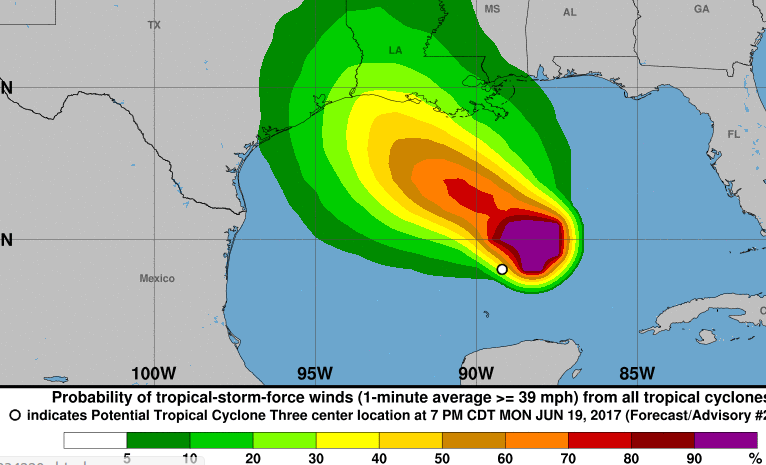
Wind: While the wind is going to be the main concern, the onset of Tropical Storm force wind will begin around 2pm along the coast, and around 8pm inland in Louisiana and western Mississippi. Alabama may never even experience Tropical Storm force wind.
NHC Tropical Storm Force Wind Probabilities
Flash Flooding: Flooding will likely being only a few hours after the onset of rainfall in your area. Since we are anticipating a push of tropical moisture from this, rainfall rates will be upwards of 1″ to 3″ per hour at times. So flash flooding will be possible after a short period of time.
River Flooding: This one is a bit trickier. I’m still learning about how local rivers react to certain types or rainfall. So I will defer to the experts. For Mississippi folks, check out our South Mississippi River Forecast page for more info. For others, consult your local NWS office for more info.
Tornadoes: I don’t think this will be a big tornado maker. But it is something that I will investigate further in the morning after all of the overnight data is rendered.
When does it all end?
I think by the time we get to Thursday afternoon things will start to dry out and slow down – but there will still be showers. By Friday, I think we will all be done with a lot of the tropical storm-related rain but there will still be showers and storms in the area. By Saturday, I think everything starts to move out.
Author of the article:
Nick Lilja
Nick is former television meteorologist with stints in Amarillo and Hattiesburg. During his time in Hattiesburg, he was also an adjunct professor at the University of Southern Mississippi. He is a graduate of both Oregon State and Syracuse University that now calls Houston home. Now that he is retired from TV, he maintains this blog in his spare time.