The Tornado Watch that expires at 1PM for parts of the southeast will likely be continued through later this evening.
Strong, long-track devastating tornadoes are not likely in this watch. But brief, weaker, and fast-moving tornadoes are possible.
The probabilities of the current watch, will likely be extended, too.
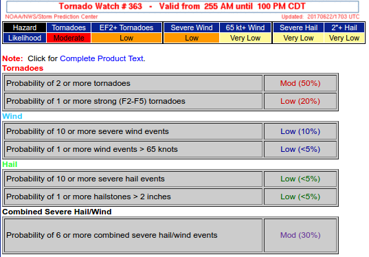
For the next few hours watch out for quick moving storms and be ready to take shelter quickly if needed.
Latest from the SPC:
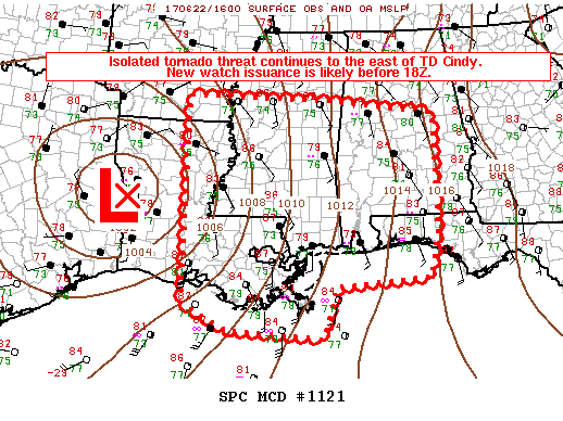
DISCUSSION…Thus far this morning, the strongest convection (and occasional rotation) has been noted across the eastern portion of WW 363, with a possible waterspout/tornado reported earlier this morning near Pensacola. This region is located within the strong belt of deep, moist southerly flow to the east of a well-defined midlevel dry slot that is wrapping into TD Cindy. While wind profiles are southerly through a deep layer, backing of the low-level flow is supporting substantial low-level shear, with 0-1 km shear of 25-35 kts noted per recent mesoanalyses and VWP data. Very warm midlevel temperatures and poor lapse rates will continue to limit the intensity of convection through the day, but the the strongest cells will pose an isolated tornado threat given the aforementioned low-level shear magnitude coincident with a very moist, tropical airmass and potential for some additional destabilization as modest heating continues. Some threat may spread north out of the watch by early afternoon, though it is unclear at this time whether any northward expansion of the watch will be necessary.
Further east, closer to the primary circulation of TD Cindy, convection has likely been inhibited by very dry midlevel air noted on WV imagery. However, greater isolation within the dry slot has allowed stronger heating to occur, and convection has begun to gradually increase across southern/eastern LA and southern MS. Continued destabilization within a low-level environment that is very moist and strongly sheared will support a gradual increase in the tornado threat through the day across portions of LA into western MS.
Since some tornado threat is likely to persist through the afternoon across WW 363, a new tornado watch will likely be required before 18Z covering generally the same area from LA eastward through MS, and perhaps northward into southeast AR and eastward into portions of AL and the FL Panhandle.