I got up this morning with every intention of running errands, working in the yard pulling out the last of that Chamberbitter, and doing some quick cleaning around the house. But when I logged onto facebook this morning to check for any questions overnight from viewers, I was bombarded with hype, disinformation and irresponsible conjecture.
And you guys know how that makes me feel.
So, I wanted to clear the air about what is going to happen in the tropics and across the Continental USA to clear up any confusion about what might be going on. Since Mississippi is my main forecast area, details will be even more detaily for there. While areas around Mississippi like Alabama and Louisiana will be a bit less detaily.
The bottom line, though is rain and inland flooding will be a concern through the next 10 days in the southeast.
Here is the latest (as of August 22, 2017) from the NOAA Weather Prediction Center:

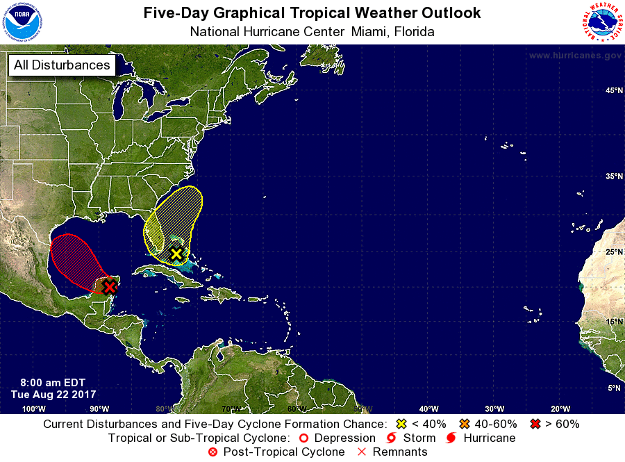
The latest from the National Hurricane Center (as of August 22, 2017), too, showing nothing directed toward Mississippi:
Forecast breakdown by state…
ALABAMA
What is going to happen:
As the pattern flips from dominating high pressure – with afternoon showers and storms – to a trough of low pressure, what is left of Harvey will be drifting by the state. This will increase the chances for rain next week. As with any remnant tropical system, there will be the chance for heavy rain and some flooding. Model guidance suggests that the heaviest rain will fall west of the state, but please keep an eye out – both here and to the local NWS – for further forecasts.
What is NOT in the forecast:
A landfalling tropical system. Nor abundant sunshine. More below…
MISSISSIPPI
What is going to happen:
Much like Alabama, as the pattern flips from high pressure – with afternoon storms – to a trough of low pressure, there will be a change in the overall weather. The difference for Mississippi is that what is left of Harvey will be drifting through the state. And due to the proximity to the storm there will be increased chances for longer duration heavier rain. So, in short, some flooding.
We talked about this late last week on the news on the 14 Day Trend. The pattern flip means a return to rainy days. What we couldn’t see is just how rainy.

Right now model guidance suggests between 3″ to 6″ is possible south of I-20. I think there will be a streak of higher amounts north of I-20 on the west side of the state, too, but figuring out where that will be is a little too difficult right now. But if you live around I-55 north of I-20 in Mississippi just know you have the potential right now for more than 6″ of rain during the week next week.
What is NOT in the forecast:
A landfalling tropical system. Nor abundant sunshine. And I can’t stress the first one enough. As of right now, with the information available there is no reason to believe that there will be a landfalling tropical system in Mississippi. I read a quick blurb kicked out by someone saying that Harvey was going to move into the Gulf and head toward Mississippi.
Model guidance disagrees.
Most every available model and every shred of model data that I could find moves the storm into the Gulf of Mexico and toward Texas. Once it moves ashore it will dabble for a few days and then move northeast and across the state of Mississippi.
Could this change? Yes. Will this change? A little. Should you be worried about a tropical system making landfall near south Mississippi? Probably not.
LOUISIANA
What is going to happen:
Folks in Louisiana are in a pickle. I tend to think you’ll end up with some of the most rain across the western side of the state. But if the forecast track shifts a bit to the west, you may also get in on some of the more typical tropical system threats like wind and surge.
What is NOT in the forecast:
Right now, a landfalling tropical system is not in the forecast, but it should be monitored. And while widespread catastrophic flooding is not in the forecast, it, too should be monitored. The band of more than 6″ of rain for western Mississippi will likely extend down into Louisiana. Figuring out where that might be, though, is still too difficult given that it is still five days away.
What about Texas and Florida?
For now I’ll defer to more local meteorologists. Matt Lanza out of Houston is a good follow for Texas weather. And Taylor Trogdon does a great job with Florida. Or you can follow the National Hurricane Center. In fact, do that anyway. The NHC is a great resource for all things Tropics.
Two brief reminders
- Since the remnants of Harvey lack any cohesive center, the models will have an inherently difficult time depicting the direction of the storm if it reforms. So please kep an eye on the forecast.
- This is probably a good time to look over your hurricane plan and check your supply kit. Because while the threat may not be imminent, its never a bad time to make sure you’re prepared.


