
Tropical Storm Harvey is now forecast to become a Major Hurricane as it drifts NW toward Texas. It is expected to make landfall on Friday night late or early Saturday morning – somewhere between just north of Corpus Christi to Brownsville. The forecast has increased the intensity due to multiple factors. Here is a look at how the forecast has changed during the previous 12 hours.
The forecast track isn’t moving much, but the effects the storm will have on Southern Texas continue to reveal themselves.
What are the threats?
1. Rain
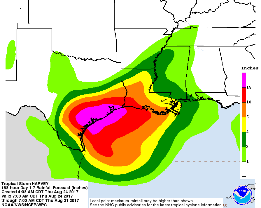
Flooding will be the biggest concern with this storm. There is the possibility for up to 30 inches of rain to fall in some spots between Corpus Christi and Houston. That means catastrophic flooding is not only possible, but probable for some areas. Figuring out specifics on who will see that flooding isn’t possible at this time, so make a plan for that NOW.
Rain will begin as early as late Thursday night. The rain may last until Monday morning. Rainfall rates up to 3″ per hour – or higher will be possible. A total of 18 to 24 inches of rain will be possible.
This is life-threatening rainfall. Please treat it as such.
2. Wind
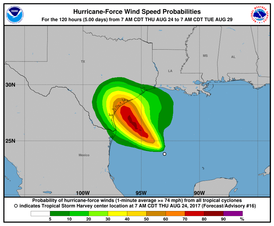
Hurricane conditions are likely within the hurricane warning area late Friday or Friday night, with tropical storm conditions expected to first reach the coast in the hurricane warning area Friday. A Category Three storm is forecast to move ashore between Corpus Christi and Angleton with wind speeds possibly at or above 110mph. If you live along the coast make preparations NOW to protect life and property. Board up windows and secure loose items outside of your home.
From the Corpus Christi NWS Office:
– Peak Wind Forecast: 75-95 mph with gusts to 125 mph
– Window for Tropical Storm force winds: Friday afternoon until Monday morning
– Window for Hurricane force winds: Friday evening until Sunday evening
3. Storm Surge
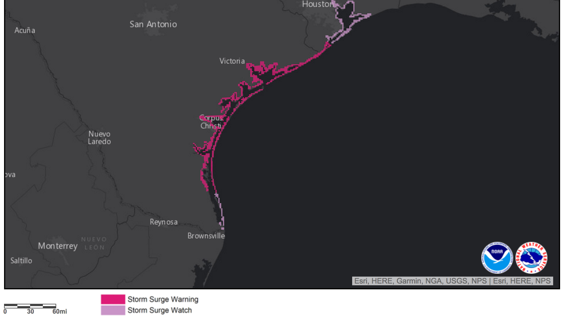
The National Weather Service says that the “storm surge threat has increased” from the previous issuance. The storm will push water from the Gulf of Mexico inland. At the peak of Storm Surge inundation there could be up to 7 to 10 feet of water above ground level somewhere within surge prone areas. This will begin as early as Friday afternoon.
From the NWS: “Life-threatening inundation is possible. Failure to heed evacuation orders may result in serious injury, significant loss of life, or immense human suffering. Leave if evacuation orders are given for your area. Consider voluntary evacuation if recommended. Poor decisions may result in being cut off or needlessly risk lives.”
National Hurricane Center Discussion
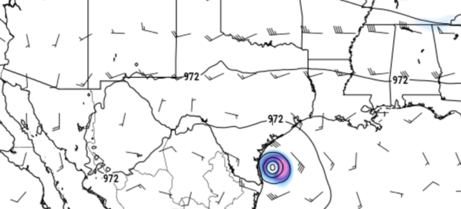
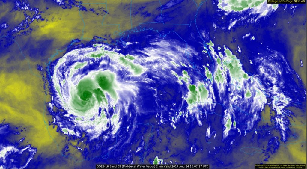
Data from an Air Force Hurricane Hunter aircraft indicate that Harvey is quickly strengthening, and the cyclone’s structure has improved markedly with the plane reporting a closed 15-20 n mi wide eye. The flight-level and SFMR winds support an intensity of 55 kt, but one of the more notable measurements is the central pressure, which has fallen to 982 mb. With a pressure this low, it is likely that the winds will respond and increase further, and Harvey probably isn’t too far from becoming a hurricane.
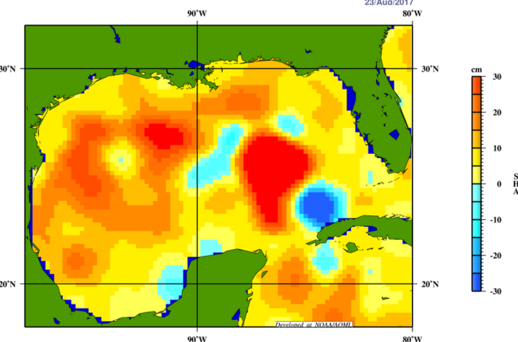
With Harvey now strengthening at a faster rate than indicated in previous advisories, the intensity forecast has become quite concerning. Water vapor images indicate that the cyclone’s outflow is expanding–indicative of low shear–and Harvey will be moving over a warm eddy of high oceanic heat content in the western Gulf of Mexico in about 24 hours. As a result of these conditions, several intensity models, including the ICON intensity consensus, are now
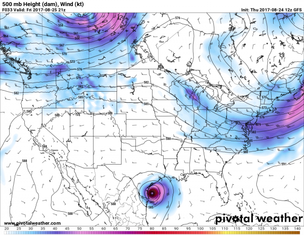
explicit showing Harvey reaching major hurricane intensity. What’s more astounding is that some of the SHIPS Rapid Intensification indices are incredibly high. As an example, the guidance is indicating a 70 percent chance of Harvey’s winds increasing by 45 kt over the next 36 hours. Based on this guidance, the NHC official intensity forecast now calls for Harvey to reach major hurricane strength by 36 hours, before it reaches the middle Texas coast.Aircraft fixes indicate that Harvey has turned toward the north-northwest, and the initial motion estimate is 340/9 kt. A mid-level high centered near Florida and the eastern Gulf of Mexico should force Harvey toward the northwest later today, with that trajectory continuing for the next couple of days. By 48 hours, the cyclone appears to get sandwiched between the same mid-level high over the Gulf of Mexico and a larger high over the Intermountain West, which will cause Harvey to slow down considerably during its approach toward the Texas coast and then potentially stall just inland on days 3 through 5. Mainly based on an adjustment of the initial position, the NHC forecast track has been nudged northeastward on this cycle, but it still lies relatively close to the TVCN multi-model consensus and the HFIP Corrected Consensus Approach (HCCA).
It is critical that users not focus on the exact forecast track of Harvey, since cycle-to-cycle adjustment are likely. All locations within the hurricane and storm surge warning areas should be preparing for the possibility of major hurricane-force winds and life-threatening storm surge.
Model Data Extras
Most of the modeling continues to show a similar story.
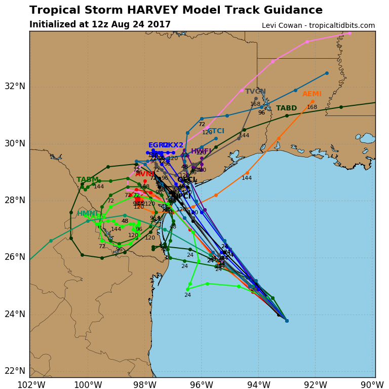
While the intensification modeling has had to catch up to real life reading, the forecast track guidance is roughly unchanged.
The explosion of convection last night allowed Harvey to speed up a bit and shuffle a bit to the north, but the general trend of landfall in southern Texas between Corpus Christi and Houston is still the same.
Through the day today, more short-range modeling will be available to meteorologists in order to get a better handle on specifics.
Looking at some of the factors that control hurricane development, here is the brief rundown:
– Local areas of atmospheric shear have subsided
– Water temperatures remain quite warm (in the upper 80s) at the surface and at depth (26-degree celsius isotherm depth at 60 meters to 100 meters)
– Water vapor imagery shows no pockets of dry air near the storm.
– Steering flow is weak, allowing the storm to meander over warm waters
Always Remember
There are a lot of places to get weather information. Always trust your local National Weather Service office and Emergency Managers, the National Hurricane Center, and local media to give you the immediate life-saving information.


