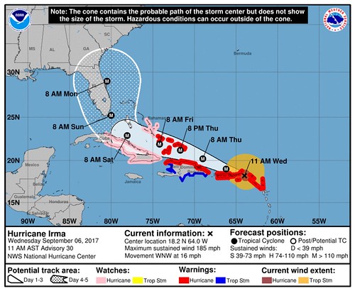
Irma is still a major Hurricane. Wind speeds at 185mph put it as a Category 5 storm. It continues to move west-northwest at 15mph.
Here is the latest Satellite image of Irma, thanks to the GOES-16 Satellite and College of DuPage Meteorology.
AM #Irma image pic.twitter.com/YgVwlw73eY
— Nick Lilja (@NickLilja) September 6, 2017
We are starting to get picture in of what happened to the islands that took a direct hit from the storm:
[IRMA] Saint Martin dans le mur de l’oeil subit les effets de l’ouragan IRMA #iram #ouragan #SaintMartin (Source : Rinsy Xieng) pic.twitter.com/e2j7e9KtOu
— RCI Guadeloupe (@RCI_GP) September 6, 2017
L’aéroport de Saint Martin dévasté après le passage d’Irma! ✈️⛈ #avgeek pic.twitter.com/sSNXLwZk2N
— airplus (@airplusnews) September 6, 2017
#HURRICANE IRMA 06/09/17 #Marigot By Laurent Petit ce matin #StMartin ##SXM #IRMA pic.twitter.com/deDDVVu9iF
— Jérémy Edouard (@bienglace) September 6, 2017
The pictures that surface in the coming days will likely tell a similar story. Really tragic. This is a very powerful storm.
And it continues moving toward the United States. But before you get too concerned, here is an objective look – in plain English – at the storm and what you need to know about it. Between those images, the stories from Harvey, and everyone’s memories of KAtrina, the last thing we need is hyperbole. So here is a #nofilter look at everything Irma. Still borrowing a line from former United States Secretary of Defense Donald Rumsfeld, we are going to look at the known knowns. The known unknowns. And the unknown unknowns.
Known knowns
HurricaneIrma is a Category 5 storm in the Atlantic Ocean. Wind speeds are at 185mph.
That is comparable to an EF-4 tornado.
Hurricane-force wind extend out from the center up to 45 miles. It is moving at – about- 15mph to the west-northwest. The eye of Irma passed over Barbuda, St. Barthelemy, and St. Martin early this morning, and will be moving over portions of the British and U.S. Virgin Islands soon. The National Hurricane Center thinks this will continue as a Category 4 or stronger storm through Sunday.
Irma is being influenced by a ridge of High Pressure to the northeast of the storm, and will keep it moving in the same direction for the next 48 hours. By Saturday, Irma will start to be influenced by a trough of Low Pressure and make a turn to the north.
From the National Hurricane Center:
The track guidance is in good agreement during this period and the NHC track is along the southern edge of the guidance envelope in best agreement with the ECMWF and HFIP corrected consensus model. After that time, a shortwave trough moving southward over the east-central United States is expected to erode the western portion of the ridge. As a result, Irma is forecast to turn northwestward and northward, but there is still a fair amount of uncertainty regarding the exact timing and location of recurvature. The NHC forecast has been shifted eastward to be in better agreement with the latest model guidance, however it should be noted that there are numerous GEFS and ECMWF ensemble members that take Irma over and/or west of Florida.
Irma will eventually turn north after being influence by other factors int he atmosphere, the question is when. The general idea is somewhere between late Saturday night and early Monday morning.
The sea surface temperatures are warm in the open Atlantic. Currently temps are sitting in the Top 3 warmest during last 20 years trailing only 1998 and 2005. The atmospheric environment ahead of the storm is sufficient for sustaining or the continued strengthening of Irma.
Known unknowns
This is still the most important thing, and we still don’t know for sure: When – exactly – it will turn north. This is still due to a handful of factors. We are still watching the same group of atmospheric parameters as before:
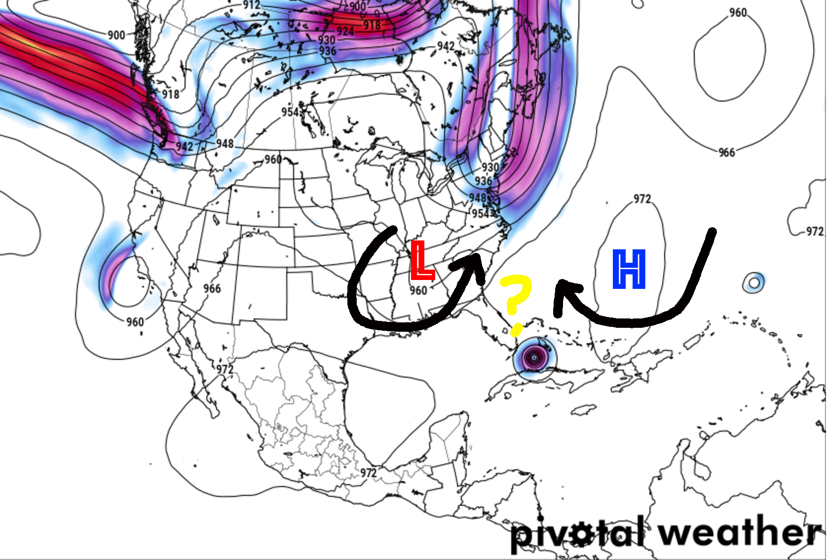
1. Placement of ridge of High Pressure in the Atlantic
2. Strength of ridge of High Pressure in the Atlantic
3. Placement of the trough in the eastern 2/3 of the US later this week
I’m adding a few things that may also change some things, too:
4. Placement of a lingering area of mid-level low pressure behind the trough mentioned above
5. Strength of that mid-level low
6. How close Irma gets to the islands of Puerto Rico, the Dominican Republic/Haiti, and Cuba
7. Influence of Tropical Storm Jose on the Ridge mentioned above
While we are stating to get a better idea of 1, 2, and 3 thanks to the Hurricane Hunters, we still won’t have a good picture of what we are looking at until Friday.
As for 4 and 5, those are new wrinkles pointed out best by Philippe Papin.
Another deep dive into #Irma‘s steering. As #TC approaches #Florida, elongated trough over US imparts local steering, causing sharp N turn. pic.twitter.com/NfFeMYIzJR
— Philippe Papin (@pppapin) September 5, 2017
The idea is that the relationship between the size and strength of an area of mid-level Low Pressure (numbers 4 and 5 above) and the area of High Pressure in the Atlantic (numbers 1 and 2 above) will dictate the exact track. But until we get closer, this is still a known unknown. And something we will all be watching closely. And then there is the interaction of those with Jose (number 7). If Jose can put a dent (in both placement and strength) in that ridge of High Pressure (numbers 1 and 2) there is still a chance this misses Florida. That said, at that point, it becomes a Georgia / South Carolina issue.
And the above-mentioned relationship is then also contingent on the results of the number 6 above, too. If Irma tracks over every single island it will likely slow a bit more and weaken. The weaker it gets the more that may change the overall tendencies the storm has to follow the steering flow.
But because none of this is nailed down, yet, there ar still multiple different possible outcomes. That is why you see stuff like this on social media…
Hurricane Irma forecasts still in flux. After suggesting the Keys yesterday, models back to a ride up the Atlantic coast of Florida. pic.twitter.com/ETTUD7NqVB
— Jason Furtado (@wxjay) September 6, 2017
Models shift Irma east, saying threat increases to east coast & decreases to FL gulf. Could shift back, so NHC holds steady (west) for now. pic.twitter.com/9UkWjqz18z
— Adam Sobel (@profadamsobel) September 6, 2017
NEW MODELS ARE IN!! Keep in mind Irma is still a power Catergory 5 hurricane so SFLO will feel impacts! pic.twitter.com/rujHUWfIUt
— WPLG Local 10 News (@WPLGLocal10) September 6, 2017
There are other differences between the American (GFS) and European (ECMWF) models. And their ensembles. But I will say, things are starting to come into much better agreement on that end. Then, of course, there are differences between those and the shorter-term models like the HWRF, HMON and TABS, TABM, TABD models. The good news? The Hurricane Hunters continue to take readings and collect data in and around Irma. That added data is helping those above-mentioned models create better forecasts.
That is why you see a lot of these things starting to overlap and agree with each other.
I will say, though, it is probably encouraging for folks in Louisiana, Mississippi and Alabama to see very few lines on those models pointing toward them. For folks in Florida, Georgia, and South Carolina please keep a VERY close eye on this storm. And depending on where you live in those states, it may be time to act. Listen to local officials and Emergency Management. If they say evacuate, do it.
But given the nature of this storm and the atmosphere, it is important that you keep up with the forecast – wherever you live – as any hiccup in there could change the forecast drastically.
Unknown unknowns
Because it is the atmosphere, there are going to be things that are going to happen that we cannot foresee at this time. That is why it is important to be prepared for all possible outcomes. Live along the East Coast? Or along the Gulf Coast? Check your Hurricane Preparedness Kit. Don’t have one? Buy one! Here is a great link for that. There is no need to do much else yet. Check your plan, make sure your kit is ready to go and wait for the meteorological world to figure out what will happen with Irma.
Being prepared today means when it is time to act, you’ll be ready to go!
The Numbers game
Real quickly, I wanted to help ease the fears of some folks, and perhaps get the attention of others. Here is a tweet from the NHCBot with the percent-change you see Tropical Storm-force wind speeds during the next five days
Hurricane Irma: 5-Day Uncertainty Track Image and 34-Knot Wind Speed Probabilitieshttps://t.co/HNjtGAnVof pic.twitter.com/UKS0xTGztV
— NHC Bot (@nhcbot) September 6, 2017
If you are living in the Florida peninsula or the Bahamas, it is time to do something and put your Hurricane Plan into action. You are likely being asked to evacuate. Do it. Listen to Emergency Officials.
If you are living in Georgia or South Carolina, it is time to review your Hurricane Plan and make sure your Hurricane Preparedness Kit is stocked and ready to go.
If you are living in Louisiana, Mississippi or Alabama, it is time to review your Hurricane Plan while keeping an eye on the forecast.
In my area, South Mississippi, I’ve got a lot of feedback from people who are VERY concerned that this will go right for this area. They say things like “No one thought Katrina would turn” or “These storms have a mind of their own, look at Katrina” and get a bit more stressed than I think is necessary.
For those who are hearing this from friends or family and are becoming a bit concerned, let me help ease your fears.
Our model data we use to forecast is run on computers and servers. They are big and powerful. And can do a lot of stuff to help make the forecast a bit clearer.
Katrina was in 2005. The best processor we had running the servers was, like, a 64-bit Intel® Xeon® MP. It had one core and was running at 3.33 GHz
Now, we have Intel® Xeon® Platinum 8180 Processor. It has 28 cores and those run – simultaneously – at 3.8 GHz.
Here is a video of computer nerds (like me) testing it out:
While not everyone is the most computer-literate, the difference between 1 x 3.3 and 28 x 3.8 should be pretty straight-forward.
Our computing power, our understanding of land-sea-air interaction, our research have all increased in the last 12 years. To borrow another line, we (scientists) are smarter, faster, stronger. When it comes to high-impact events, we have the ability to see more, understand more, and predict more.
Also, YOU have access to more technology, too. You have a phone in your hand that is faster than the desktop computers of 2005. You have access to the internet – almost – everywhere. You can find all of the forecasts (like the one on this site) whenever you want it.
So, could Irma turn later and impact the Gulf Coast? Certainly it is a possibility.
But unlike in 2005, when the only means of getting this information was from your 6pm news, you will know about it sooner, you’ll have more time to react, and you shouldn’t be caught off-guard if the forecast changes.


