Good morning again, everyone. We are tracking another opportunity for severe weather as we move through the day today and into the afternoon.
Take a preliminary glance at the current surface observations and a quick look at the short-range RAP computer weather model, I think that we could see another violent day across the southeast in parts of Mississippi, Alabama, Tennessee and Georgia. But there is also the threat for severe weather in Kentucky, Ohio, Indiana and Illinois.
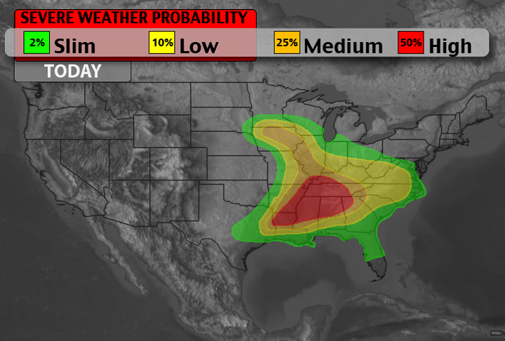
I’ll be adding a timetable for each zone to this post shortly. For now, please take a look at the severe weather potential map for today.
Arkansas, Mississippi, Tennessee
10AM – 3PM
Showers and storms will continue to migrate northeast. Behind and between these storms sunshine will filter into the area and increase the instability. The front is currently draped to the west of the area will become a focal point for convection into the afternoon, but storms that fire this morning and into the early afternoon will not be the storms that are of the most concern.
Any lingering storms this morning will still have high winds and possible quarter to half dollar-sized hail. Also, there is the potential for flooding as these storms are going to tend to “train” over the same areas. But these will not be the significantly severe storms anticipated this afternoon and evening.
Interesting note: If storms linger around in the area long enough, this could significantly diminish the severe weather threat into the afternoon and evening hours. But the current thinking is that these storms will diminish and then afternoon and evening storms will redevelop.
3PM – 8PM
Storms will begin to refire across roughly the same areas that are currently seeing thunderstorm activity. Current computer weather models suggest initiation to start around 4pm. This will happen from Lake Charles, Louisiana to Paducah, Kentucky. These storms will initially fire as individual supercell thunderstorms. And this is when they will be most dangerous.
Main threats with these storms will be damaging winds, large hail, flash flooding and tornadoes.
Right now, computer weather models are having a tough time deciding on the available low-level shear which is why the tornado threat could vary as the day continues. This is going to be a very tricky scenario that will be watched closely.


