Irma is a Category Five hurricane. It has wind speeds of 160mph.
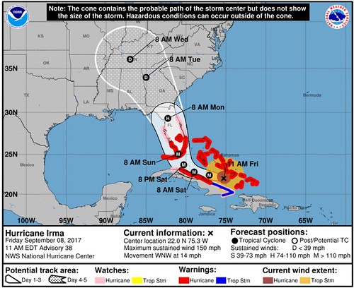
The storm is nearly 500 miles from west to east. It is moving to the west at 14mph. That movement though, isn’t as consistent as earlier. It continues to meander to the west overnight, but latest satellite data suggests the storm may have started to make a northward shift. Or it is a short-term wobble.
GOES-16 of #Irma and #Katia pic.twitter.com/rPQeMAdamM
— Nick Lilja (@NickLilja) September 9, 2017
Irma is on the right. Katia on the left. We won’t know if Irma’s shift is a wobble or a trend for another hour. Maybe more. If it is a turn, it would be bad news for Miami. If not, it continues to be bad news for Cuba and the west coast of Florida.
Either way, Irma continues moving toward the United States. But before you get too concerned, here is an objective look – in plain English – at the storm and what you need to know about it. Between the images from the Leeward Islands, the stories from Harvey, and everyone’s memories of Katrina, the last thing we need is hyperbole. So here is a #nofilter look at everything Irma. Still borrowing a line from former United States Secretary of Defense Donald Rumsfeld, we are going to look at the known knowns. The known unknowns. And the unknown unknowns.
Known knowns
HurricaneIrma is a Category 5 storm, with wind speeds of 160mph, in the Atlantic Ocean just north of Cuba. The outer bands of the storm are already in Miami. At last check in Miami, (as of 12:40am, 9/9/17) there was already a wind gust greater than 50mph reported.
The official stats from the National Hurricane Center:
ESTIMATED MINIMUM CENTRAL PRESSURE 924 MB
EYE DIAMETER 30 NM
MAX SUSTAINED WINDS 140 KT WITH GUSTS TO 170 KT.
64 KT……. 60NE 60SE 30SW 60NW.
50 KT…….100NE 90SE 50SW 80NW.
34 KT…….160NE 120SE 80SW 150NW.
12 FT SEAS..420NE 30SE 30SW 30NW.
The weakest side of the storm is on the southwest side. On all other sides, the hurricane-force wind speeds reach out 60 miles.
More from the National Hurricane Center:
Apparently the ridge to the north of Irma has been stronger than expected, and the initial motion remains westward, or 280/11 kt. The track guidance continues to insist on Irma turning west-northwestward soon, moving along the Cuban Keys adjacent to the north coast of Cuba during the next 24 hours. After that time, Irma is expected to turn sharply north-northwestward and accelerate after 48 hours, moving parallel to the west coast of Florida and then into Georgia. Mainly because Irma’s eye has not deviated from its westward motion, the new NHC forecast track has again shifted slightly westward. Because of the hurricane’s angle of approach to the west coast of Florida, it is extremely difficult to pinpoint exactly where the center might move onshore.
Take home point: It will turn. Meteorologists are confident that it will during the next six to 12 hours. But the exact moment? That is what is still unknown (more on this below).
HAZARDS AFFECTING LAND
———————-
STORM SURGE: The combination of a dangerous storm surge and the tide will cause normally dry areas near the coast to be flooded by rising waters moving inland from the shoreline. The water is expected to reach the following HEIGHTS ABOVE GROUND if the peak surge occurs at the time of high tide…SW Florida from Captiva to Cape Sable…8 to 12 ft
Cape Sable to Boca Raton including the Florida Key…5 to 10 ft
Venice to Captiva…5 to 8 ft
Anclote River to Venice including Tampa Bay…3 to 5 ft
Boca Raton to Flagler/Volusia County line…2 to 4 ft
Anclote River to Suwannee River…3 to 6 ftThe deepest water will occur along the immediate coast in areas of onshore winds, where the surge will be accompanied by large and destructive waves. Surge-related flooding depends on the relative timing of the surge and the tidal cycle, and can vary greatly over short distances. For information specific to your area, please see products issued by your local National Weather Service forecast office.
The combination of a life-threatening storm surge and large breaking waves will raise water levels ABOVE NORMAL TIDE LEVELS by the following amounts within the hurricane warning area near and to the north of the center of Irma. Near the coast, the surge will be accompanied by large and destructive waves.
Ragged Island in the Bahamas…15 to 20 ft
Central and Northwestern Bahamas…3 to 6 ft
Northern coast of Cuba in the warning area…5 to 10 ftWIND: Hurricane conditions are still occurring over portions of the central Bahamas, as well as Ragged Island. Hurricane conditions are expected to continue within the hurricane warning area along the north coast of Cuba through Saturday. Hurricane conditions are expected in the northwestern Bahamas tonight and Saturday, and in portions of southern and central Florida and the Florida Keys Saturday night and Sunday.
Hurricane and tropical storm conditions are possible within the watch area in central and north Florida by Sunday.
RAINFALL: Irma is expected to produce the following rain accumulations through Tuesday night:
Southern Bahamas and northern Cuba…10 to 15 inches, isolated 20 inches
Southern Cuba…5 to 10 inches, isolated 15 inches
Jamaica…1 to 2 inches
The Florida Keys, much of the Florida peninsula, and southeast
Georgia…8 to 15 inches, isolated 20 inches
The Florida Panhandle…3 to 6 inches, isolated 8 inches
Rest of Eastern Georgia, western South Carolina, and Western North
Carolina…4 to 8 inches
Western Georgia, eastern and northern Alabama, and southern Tennessee…2 to 5 inchesIn all areas this rainfall may cause life-threatening flash floods and, in some areas, mudslides.
TORNADOES: A few tornadoes are possible from Saturday midday into Sunday across central and south Florida.
SURF: Swells generated by Irma are affecting the southeastern Bahamas, the Turks and Caicos Islands, the northern coast of the Dominican Republic, and should start affecting portions of the southeast coast of the United States tonight. These swells are likely to cause life-threatening surf and rip current conditions. Please consult products from your local weather office.
The sea surface temperatures are warm in the area near Cuba, the Bahamas and Florida. Currently temperatures across the Atlantic are sitting in the Top 3 warmest during last 20 years trailing only 1998 and 2005. The atmospheric environment ahead of the storm – during the next 24 hours – is sufficient for sustaining or the continued strengthening of Irma.
Known unknowns
When – exactly – it will turn north. This is still due to a handful of factors. We are still watching the same group of atmospheric parameters as before to figure out the eventual path:
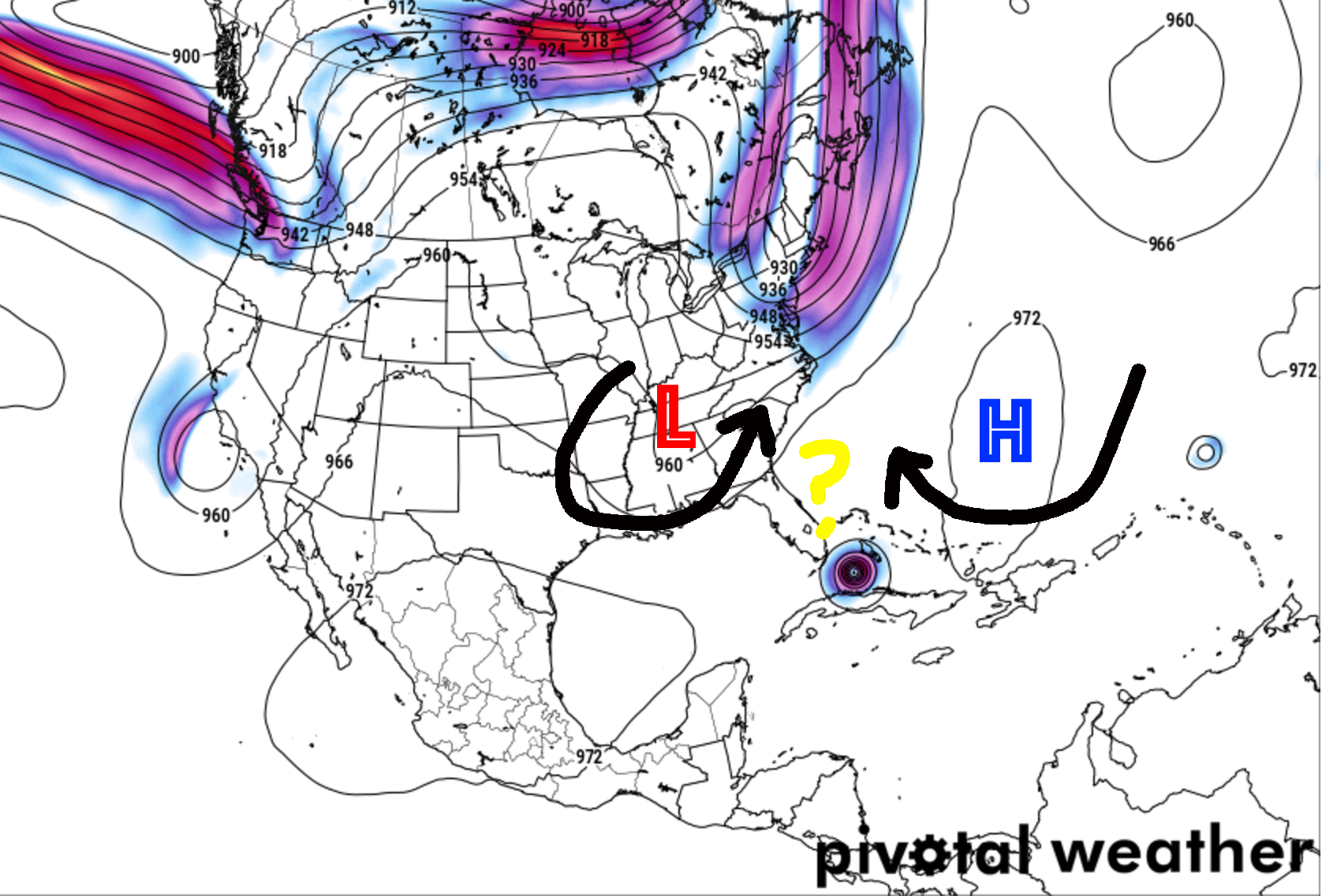
1. Placement of ridge of High Pressure in the Atlantic
– We have a pretty good handle on teh center of it, but the little elbow of it that extends across Florida is tricky. it is difficult to pinpoint exactly where it is and where the weakness in it is, too.
2. Strength of ridge of High Pressure in the Atlantic
– So far, as noted by the National Hurricane Center, the ridge has been more stubborn than predicted, allowing Irma to make it further West than anticipated. Meteorologists aren’t sure when there will be sufficient weakness to allow it to move north. The turn could start in an hour or in six hours.
3. Placement of the the shortwave trough / mid-level low in the southeast
– There are a few pieces of atmospheric energy diving to the southeast from the Rockies during the next few days. The exact placement of these is unknown, we have a pretty good idea about where they are headed, but pinpointing it isn’t possible. And the placement will have a big impact on how far west Irma will stay as it moves north.
4. Strength of that mid-level low
– The stronger it is, the more bending back to the east that Irma will do as it moves north.
6. What influence – if any – the interaction with Cuba has on Irma
– Land-Sea interactions in tropical systems are tricky. I’m not even going to act like I understand them. At all. This is almost an unknown unknown.
And, truly, until Irma turns north, a lot of these known unknowns will remain unknown. That is what is making this forecast so difficult. IT is also the reason that spaghetti plots continue to shift west and why the official forecast does, too.
With each spaghetti plot, #Irma continues a westward track & puts Tampa & Fort Myers in a perilous position. #KVOAwx pic.twitter.com/nw5JP84Gxp
— Jeff Beamish (@jeffbeamish) September 9, 2017
Overnight (00Z) Euro model almost perfectly in line with the current NHC forecast, taking Irma up the west coast of Florida. pic.twitter.com/kzoPzjLB1s
— Eric Holthaus (@EricHolthaus) September 9, 2017
Delayed landfall S of Tampa Bay would subject entire FL peninsula to potential hurricane force winds. Gusts considerably more
(ECMWF) #Irma pic.twitter.com/EvEyjPM95V— Ryan Maue (@RyanMaue) September 9, 2017
The general trend between the models is that once Irma turns north, it will move – mostly – north-northwest. that is why you see a lot of these things starting to overlap and agree with each other.
I will say, though, it is probably encouraging for folks in Louisiana and Mississippi to see very few lines on those models pointing anywhere toward them. For folks in Florida, Georgia, and Alabama please keep a VERY close eye on this storm. And depending on where you live in those states, it may be time to act. Listen to local officials and Emergency Management. If they say evacuate, do it. Especially if you live within 10 miles of the Gulf.
But given the nature of this storm and the atmosphere, it is important that you keep up with the forecast – wherever you live – as any hiccup in there could change the forecast drastically.
Unknown unknowns
Because it is the atmosphere, there are going to be things that are going to happen that we cannot foresee at this time. That is why it is important to be prepared for all possible outcomes. Live along the East Coast? Or along the Gulf Coast? Check your Hurricane Preparedness Kit. Don’t have one? Buy one! Here is a great link for that. There is no need to do much else yet. Check your plan, make sure your kit is ready to go and wait for the meteorological world to figure out what will happen with Irma.
Being prepared today means when it is time to act, you’ll be ready to go!
Bottom Line
Irma will turn north during the next six to 12 hours. Once it gets through the entire turn, we will have . amuch better idea of who – specifically – will see the worst of this storm. Until then, we can speak generally about the impacts.
Florida: Get ready for – AT LEAST – Category 1 wind, heavy rain, storm surge, flooding, and in some areas, catastrophic damage at some point between now and Monday morning
Georgia: Get ready for a fair amount of rain and some Tropical Storm-force wind as well as the threat for isolated tornadoes starting Monday afternoon
Alabama: On the western size, you’ll have some wind and some rain, by Monday evening but specifics are still unclear
Mississippi: Depending on the final track, some rain with breezy conditions possible by mid-week next week
Tennessee: Rain and some wind, flooding may be possible starting Tuesday and into Wednesday, but specifics are unclear


