The internet was buzzing this afternoon as the National Hurricane Center identified another area of interest in the tropics. This time, a cluster of storms associated with a trough of low pressure located over the northwestern Caribbean Sea, is forecast to move slowly north-northwestward across Cuba and the Straits of Florida.
I’m Not a Wave, Not Yet an Invest
Props to anyone that gets that reference… Without Googling!
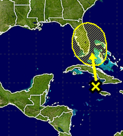
The cluster of storms is being given a 10 to 20 percent chance of development during the next two to five days. But it may struggle to do much of anything given the proximity to (1) land, (2) a mid-level area of low-pressure, and (3) slightly cooler water temperatures near Florida after both Hurricane Irma and Hurricane Maria.
Furthermore, due to the influence of an advancing backdoor cold front associated with a ridge of high pressure, it may get pushed to the west across parts of Florida and into the southeastern United States before it can get its act together.
If so, it would mean more rain for parts of Georgia, Florida and Alabama during the early half of next week. It would also mean the cooler temperatures would be shrouded by cloud cover and rainfall.
Both the GFS and European as well as the NAM (even with all of its faults during tropical weather) show a low developing near the Bahamas in association with those storms. But all three don’t show deepening convection, an expanding wind field, or any real shred of drastic intensification.
All good things.
On My Radar
Again, if you see where I’m going with these references, you get a digital high-five.
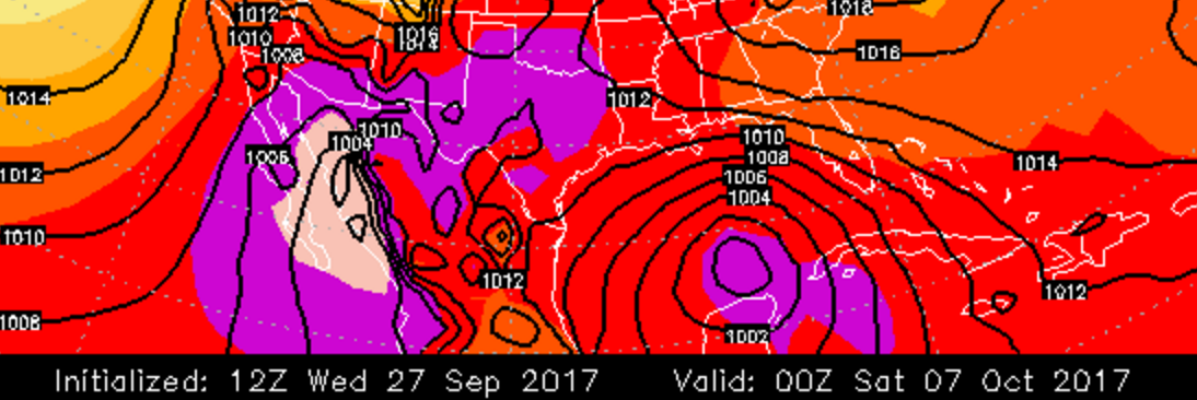
As for what is on the horizon that I am more interested in, it is actually the thing that is back in behind this first wave. Ensemble models for both the GFS and the Europeans computer weather models suggest a deepening area of low pressure trying to develop just off the tip of the Yucatan near October 7th or 8th. The operational models have also shown something trying to develop.
A lot like with other tropical systems this season, the ensemble models have done a decent job picking out where tropical systems may develop even before they emerge on satellite. Even the operational models have done an ‘okay’ job this season. The OP models still tend to spin-up too many ghost hurricanes that never materialize but, they’re getting better.
Circus
Anyone picking up on these headline names, yet?
The problem with a deepening area of low pressure near the Yucatan is that – if it remains there in subsequent model runs – social media will find it and be putting it all over the place as some Doomsday event. So a brief no-hype style look at things…
Known Knowns…
Not much right now. Honestly. We know we will have one cluster of storms lift north toward the Bahamas and then drift west. We also know that the models are hinting at another little area of low pressure trying to develop behind that.
Known Unknowns…
Strength and position of anything that doesn’t have a discernible center beyond 60 hours out. It is tough because the cluster of storms is being pushed and pulled by a handful of different forces at the moment. And until the cluster develops some sort of organization, computers will continue to struggle to identify where it will go and what it will do.
For that second area of low pressure, we know we don’t know anything yet. We are still in wait and see mode.
Unknown Unknowns…
Because it is the atmosphere, there are going to be things that are going to happen that we cannot foresee at this time. That is why it is important to be prepared for all possible outcomes. Live along the East Coast? Or along the Gulf Coast? Check your Hurricane Preparedness Kit. Don’t have one? Buy one! There is no need to do much else yet. Check your plan, make sure your kit is ready to go and wait for the meteorological world to figure out what will happen.


