Tropical Depression 16 is still a tropical depression. That said, the National Hurricane Center anticipates that TD16 will strengthen into Tropical Storm Nate before 1pm Thursday. So enjoy it while it lasts, because TD16 will be Nate soon.
The stats:
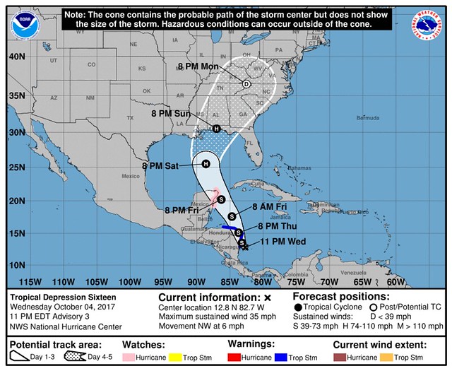
SUMMARY OF 1100 PM EDT…0300 UTC…INFORMATION
———————————————–
LOCATION…12.8N 82.7W
ABOUT 70 MI…115 KM WNW OF SAN ANDRES ISLAND
ABOUT 95 MI…155 KM SSE OF PUERTO CABEZAS NICARAGUA
MAXIMUM SUSTAINED WINDS…35 MPH…55 KM/H
PRESENT MOVEMENT…NW OR 310 DEGREES AT 6 MPH…9 KM/H
MINIMUM CENTRAL PRESSURE…1004 MB…29.65 INCHES
The center of TD16 will move across northeastern Nicaragua and eastern Honduras during the day Thursday and then over the northwestern Caribbean Thursday night and Friday. It is expected to approach the coast of the Yucatan peninsula late Friday. TD 16 is expected to strengthen to a tropical storm before it moves inland over northeastern Nicaragua tomorrow. Additional strengthening is likely over the northwestern Caribbean Sea Thursday night and Friday.
Known knowns
Tropical Depression 16 is starting to get better organized. It is anticipated to strengthen to a tropical storm during the next 12 to 24 hours as it lifts north across Central America and back into the Caribbean. The environment in the next 24 to 48 hours will feature high oceanic heat content and low shear.
Known unknowns
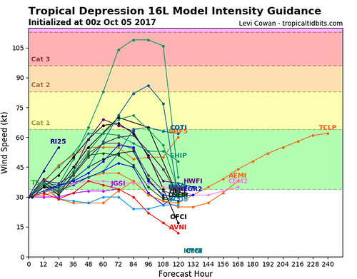
Despite these favorable conditions noted above, the amount of strengthening will be unclear until we know how well the inner core survives crossing over Nicaragua and Honduras. Beyond 72 hours out, the NHC says there are some indications that “higher shear and/or cooler shelf waters over the northern Gulf of Mexico” could limit intensification, but that scenario is by no means a definite one at this time.
From the NHC:
If the intensity forecast is complex, the track forecast is not much easier. For the first 48 hours, the models appear split on how the depression will interact with a disturbance currently located near the Straits of Florida. For example, the ECMWF model shows some interaction with the disturbance’s low-level vorticity, which swings the depression more to the east on the right side of the guidance envelope. The GFS, on the other hand, shows no such interaction and has the cyclone on the western side of the guidance envelope. This setup has significant downstream effects after 48 hours because it keeps the ECMWF on an eastern route and the GFS on a western route as the cyclone heads toward the U.S. Gulf coast. The new NHC track forecast has been shifted slightly westward, although it is still not as far west as the consensus aids or the HCCA model. Interestingly, although the ECMWF ensemble mean is close to the operational run on the eastern side of the guidance envelope, there is a high density of members to the left close to the consensus aids, which lends additional support for the westward adjustment.
Unknown unknowns
Because it is the atmosphere, there are going to be things that are going to happen that we cannot foresee at this time. That is why it is important to be prepared for all possible outcomes. Check your Hurricane Preparedness Kit. Don’t have one? Go get one! There is no need to do much else yet. Check your plan, make sure your kit is ready to go and wait for the meteorological world to figure out what will happen with TD16 / Nate.


