Tropical Storm Nate continues to move north across Nicaragua and Honduras. It will eventually – later today – get back over the warm waters of the Caribbean and begin to strengthen again.
Here is the latest from the NHC:
Known knowns
Nate has a decent inner core developing, though, it isn’t impressive. The National Hurricane Center noted that while thunderstorm activity is increasing, organization within the storm isn’t developing quite as quickly as anticipated. This is likely due to the interaction with land since it is near / on top of Latin America.
That interaction is leading to hazardous weather for the people of Latin America, though. The National Hurricane Center anticipates up to 20 inches of rain for sections of Nicaragua.
RAINFALL: Nate is expected to produce the following rain
accumulations through Friday night:Nicaragua…15 to 20 inches, isolated 30 inches
Costa Rica and Panama…5 to 10 inches, isolated 20 inches
Honduras and Eastern portions of the Yucatan Peninsula…4 to 8
inches, isolated 12 inches
Belize…2 to 5 inches, isolated 8 inchesHeavy rainfall will occur over a wide area, including locations well away from the center along the Pacific coast of Central America. Rainfall across all of these areas may produce life-threatening flash floods and mudslides.
WIND: Tropical storm conditions are expected within portions of the warning area in Nicaragua and Honduras today and tonight. Hurricane conditions are possible within the hurricane watch area in Mexico Friday night, with tropical storm conditions expected by late Friday.
SURF: Swells generated by Nate are affecting portions of the coast of Nicaragua, and will begin to affect other land areas around the northwestern Caribbean during the next day or two. These swells are likely to cause life-threatening surf and rip current conditions. Please consult products from your local weather office.
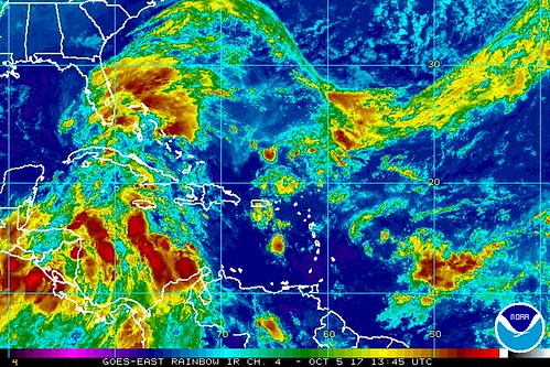
On satellite imagery, Nate looks pretty ragged.
Despite that, there are watches and warnings in effect for Central America.
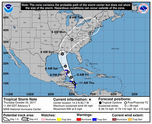
From the NHC 11AM Advisory:
SUMMARY OF WATCHES AND WARNINGS IN EFFECT:
A Tropical Storm Warning is in effect for…
* Sandy Bay Sirpi Nicaragua to Punta Castilla Honduras
* Punta Herrero to Rio Lagartos MexicoA Hurricane Watch is in effect for…
* Punta Herrero to Rio Lagartos MexicoA Tropical Storm Warning means that tropical storm conditions are expected somewhere within the warning area.
A Hurricane Watch means that hurricane conditions are possible within the watch area. A watch is typically issued 48 hours before the anticipated first occurrence of tropical-storm-force winds, conditions that make outside preparations difficult or dangerous.
Interests elsewhere in Honduras, the Bay Islands, western Cuba, the Yucatan Peninsula, and the northern coast of the Gulf of Mexico should monitor the progress of Nate.
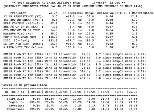
The model guidance suggests intensification.
That said, just how much intensification happens and how rapidly it happens leads us to….
Known unknowns
We don’t know specifically how much stronger Nate is going to get.
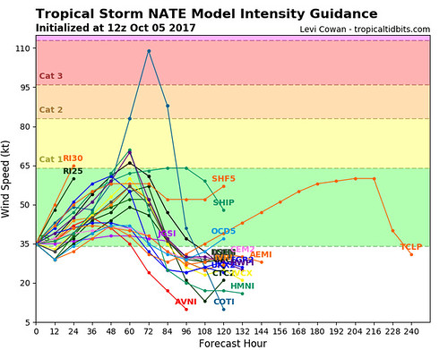
Right now model guidance is pretty consistent across the board that Nate will strengthen into a strong Tropical Storm or weak Category 1 Hurricane – however, model guidance for intensity during the 2017 Atlantic Hurricane Season hasn’t been great. It has been good. But it has definitely swung and missed a few times, too.
So that leads forecasters to question the validity of the data that is coming back from the model guidance. Meteorologists confidence in the model data should increase with time as the Hurricane Hunters continue to collect data and the storm gets closer to areas where weather data is already being collected.
Another big question mark is just how much that little area of low pressure near Florida interacts with Nate. It would be helpful for everyone, I think, if it had a designation, so for the rest of this quick blurb it will be referred to as the “Mid-Level Low” or “MLL” to keep things easy.
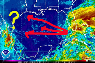
The MLL is going to drift across the Gulf from east to west. The exact trajectory is unknown. This is where it gets tough. The MLL is floating along, as a weak disorganized batch of storms around a mid-level area of low pressure with no real big steering current, it is difficult for models to pinpoint exactly where it will go. And the MLL is going to – in a sense – open the door to allow Nate to sneak in behind it and move north.
The more due west the MLL goes, the better the chance that Nate eases to the west and has more of an impact on Louisiana and Mississippi. The more northwest the MLL goes, the more Nate will tend to move east impacting Alabama and Florida.
Unknown unknowns
Because it is the atmosphere, there are going to be things that are going to happen that we cannot foresee at this time. That is why it is important to be prepared for all possible outcomes. Check your Hurricane Preparedness Kit. Don’t have one? Go get one! There is no need to do much else yet. Check your plan, make sure your kit is ready to go and wait for the meteorological world to figure out what will happen with Nate.


