1AM UPDATE: Overnight Tropical Storm Nate data and details
Author: Nick Lilja
|| Published: 10/6/2017 at 12:55am
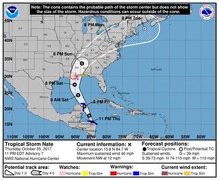
As of 12:15am Central Time, Tropical Storm Nate is back over the open waters of the Caribbean Sea. Water temperatures in the area are running between 82 and 87 degrees. The warm waters and the lower environmental shear will allow Nate to increase in size and intensity during the next 24 to 48 hours.
11PM Advisory from the National Hurricane Center // Courtesy: NHC.NOAA.GOV
SUMMARY OF 200 AM EDT…0600 UTC
———————————————-
LOCATION…16.1N 84.8W
ABOUT 75 MI…125 KM ESE OF ISLA GUANAJA HONDURAS
ABOUT 320 MI…515 KM SSE OF COZUMEL MEXICO
MAXIMUM SUSTAINED WINDS…45 MPH…75 KM/H
PRESENT MOVEMENT…NW OR 325 DEGREES AT 12 MPH…19 KM/H
MINIMUM CENTRAL PRESSURE…999 MB…29.50 INCHES
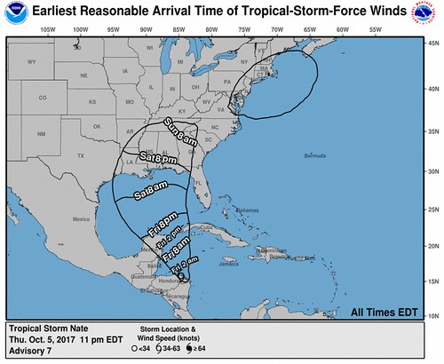
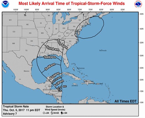
The National Hurricane Center is still projecting Nate to remain a tropical storm between leaving Honduras and making a second landfall in Mexico near Cancun.
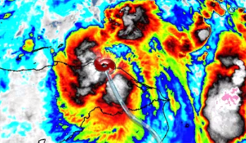
10/6/17 12:15 AM GOES 16 Infrared Imagery of Tropical Storm Nate
The NHC forecast then takes the storm across the Gulf of Mexico – quickly – and into either Louisiana, Mississippi or Alabama Saturday night or early Sunday morning as a Category 1 Hurricane.
Given the timing of landfall is within 48 hours, The NHC coordinated with local National Weather Service offices to ifssue watches for counties and parishes along the Gulf Coast and inland.
Here is the latest from the National Hurricane Center and the National Weather Service:
A Storm Surge Watch has been issued from Morgan City, Louisiana,
eastward to the Alabama/Florida border, including the northern and
western shores of Lake Pontchartrain.
A Hurricane Watch has been issued from Morgan City, Louisiana,
eastward to the Mississippi/Alabama border, including metropolitan
New Orleans, Lake Pontchartrain, and Lake Maurepas.
A Tropical Storm Watch has been issued from the Mississippi/Alabama
border eastward to the Okaloosa/Walton County Line in Florida. A
Tropical Storm Watch has also been issued west of Morgan City to
Intracoastal City, Louisiana.
The government of Nicaragua has discontinued the Tropical Storm
Warning for Nicaragua.
SUMMARY OF WATCHES AND WARNINGS IN EFFECT:
A Tropical Storm Warning is in effect for…
* Punta Castilla Honduras to the Honduras/Nicaragua border
* Punta Herrero to Rio Lagartos Mexico
A Storm Surge Watch is in effect for…
* Morgan City Louisiana to the Alabama/Florida border
* Northern and western shores of Lake Pontchartrain
A Hurricane Watch is in effect for…
* Morgan City Louisiana to the Mississippi/Alabama border
* Metropolitan New Orleans
* Lake Pontchartrain and Lake Maurepas
* Punta Herrero to Rio Lagartos Mexico
A Tropical Storm Watch is in effect for…
* Mississippi/Alabama border to the Okaloosa/Walton County Line
* West of Morgan City to Intracoastal City Louisiana
A Tropical Storm Warning means that tropical storm conditions are
expected somewhere within the warning area.
A Storm Surge Watch means there is a possibility of life-
threatening inundation, from rising water moving inland from the
coastline, in the indicated locations during the next 48 hours.
For a depiction of areas at risk, please see the National Weather
Service Storm Surge Watch/Warning Graphic, available at
hurricanes.gov.
A Hurricane Watch means that hurricane conditions are possible
within the watch area.
A Tropical Storm Watch means that tropical storm conditions are
possible within the watch area, generally within 48 hours.
Interests elsewhere in Honduras, the Bay Islands, western Cuba, the
Yucatan Peninsula, and the northern coast of the Gulf of Mexico
should monitor the progress of Nate.
For storm information specific to your area, please monitor
products issued by your national meteorological service.
Warm waters mean intensification possible
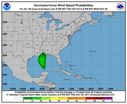
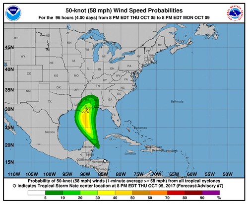
The sea-surface water temperatures in the Caribbean are quite warm. But the water is also warm at depth. The 26C isotherm in sections of the western Caribbean and the straight between the Yucatan and Cuba as well as the loop current into the Gulf of Mexico are adequate to aid the rapid intensification of tropical systems.
The question becomes, will the atmosphere will ease back on the shear and allow the storm to wrap itself up? Or will we see something like what happened with Harvey where a burst of overnight convection (likely aided by the incredibly warm water) dropped the central pressure and prompted intensification?
From the NHC:
Due to low shear and very high oceanic heat content in the northwestern Caribbean Sea, Nate should at least steadily strengthen once it moves offshore, especially since it appears to have a well-defined inner core. Rapid intensification is still not out of the question, and Nate could be near hurricane intensity by the time it reaches the Yucatan coast in about 24 hours. Land interaction with the Yucatan peninsula could cause a brief hiatus in the strengthening trend, but conditions should be conducive for additional intensification while Nate is over the Gulf of Mexico. Overall, the intensity models have not changed much on this cycle, and the NHC forecast still calls for a 48-hour intensity of 70 kt, which is at the upper end of the guidance between HWRF and HCCA. As mentioned before, Nate could strengthen further in the time between the 48-hour position and when it crosses the U.S. Gulf coast.
Stu Ostro caught the little low-level spin on radar just off the coast of Florida today. The low-level spin is associated with an area of mid- and upper-level low pressure.
The original thinking was the mid- and upper-level low (we’ll just call it MLL for short) would swing west across the Gulf and “open the door,” so to speak, for Nate to move north.
With it exhibiting an area of low-level low pressure, too, now it becomes more interesting. Not really sure what to make of it, honestly.
It could bend Nate further west or push it more to the east as it moves through the Gulf. It is something that needs to be monitored closely.
The wind is gunna blow…
Author of the article:
Nick Lilja
Nick is former television meteorologist with stints in Amarillo and Hattiesburg. During his time in Hattiesburg, he was also an adjunct professor at the University of Southern Mississippi. He is a graduate of both Oregon State and Syracuse University that now calls Houston home. Now that he is retired from TV, he maintains this blog in his spare time.