Hurricane Nate gaining strength, track leaning east
Author: Nick Lilja
|| Published: 10/6/2017 at 11:52pm
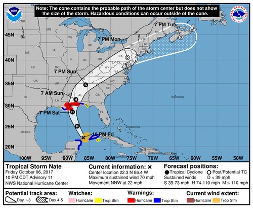
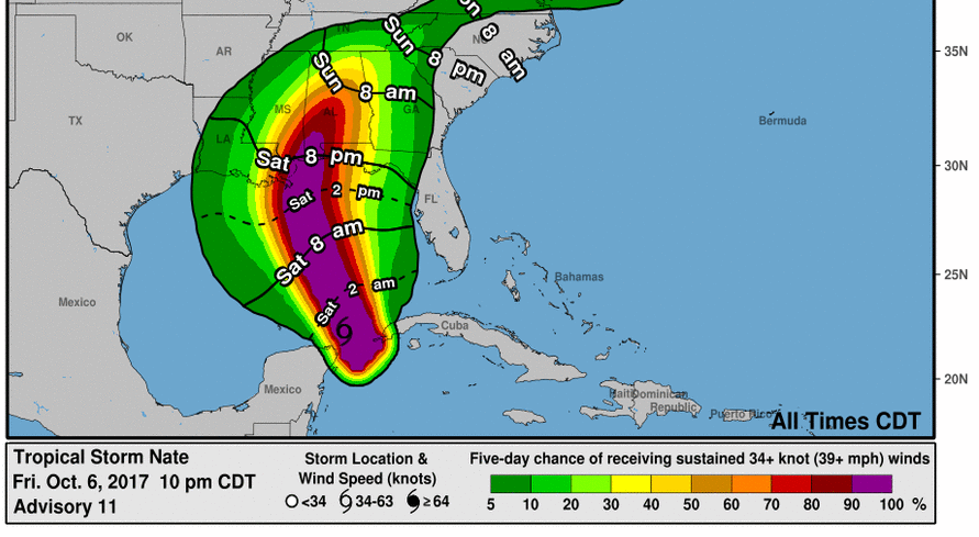
The 10pm update was release by the National Hurricane Center showed “Tropical Storm Nate” with wind at 70mph.
Twenty-five minutes later…
It isn’t surprising though based on satellite trends, between 8pm and 10pm the area of deep convection nearly tripled.
Nate become the ninth hurricane of the season.
#Nate is now a hurricane – the 9th of 2017 Atlantic TC season – the most in a season since 2012 and tied for 15th most on record. pic.twitter.com/aZz8MeJYK7
Meteorologists on Twitter were noting the uptick in convection and the possibility of strengthening before the Hurricane Hunters found “ground truth” of the increase in intensity.
Like any land-falling tropical system, rain, wind and isolated tornadoes will be possible.
Severe weather threat // Courtesy: Storm Prediction Center
For specifics, I’ll break it down by area…
WHERE DO I LIVE?
SOUTHERN LOUISIANA (but not along the coast) – Rain and wind. Rainfall rates as high as 2″ to 3″ per hour. Wind gusts approaching 60mph. It looks like the main track may lean away from you a bit. If you live west of Baton Rouge, you don’t have much to worry about at this time.
LOUISIANA COAST – Rain, wind and some surge. Rainfall rates as high as 2″ to 3″ per hour. Wind gusts approaching 60mph. Storm surge may approach more than six feet above ground level.
SOUTHERN MISSISSIPPI – Live south of I-20 and east of I-55? Listen up. Between I-55 and I-59 will be the trickiest forecast. There will be a pretty big increase in impacts as you move east. If you live in McComb you may not get much more than some rain and gusty wind, while down the road in Columbia you may see heavy rain, localized flooding, wind gusts to 50mph and the possibility of an isolated tornado.
In general across south Mississippi, rainfall rates between 1″ and 3″ per hour will be possible. Sustained wind speeds around 50mph. Wind gusts may approach 70mph. And there will be the chance for a few isolated tornadoes.
MISSISSIPPI COAST – With the anticipated strengthening, this forecast deviates from the National Hurricane Center forecast: Rain, wind and some surge are possible. Rainfall rates as high as 3″ to 5″ per hour. Sustained wind speeds around 85mph will be possible. Wind gusts approaching 100mph – or higher – may be possible. Storm surge may approach more than eight feet above ground level.
Landfall may occur along the Mississippi coast.
SOUTHERN ALABAMA – In and around the Mobile area, Orange Beach, Foley and points nearby and in-between rain, localized flooding, wind and isolated tornadoes will be possible. Rainfall rates between 2″ and 4″ per hour. Wind gusts will approach 100mph.
ALABAMA COAST – With the anticipated strengthening, this forecast deviates from the National Hurricane Center forecast: Rain, wind and some surge will be possible. Rainfall rates as high as 3″ to 5″ per hour. Sustained wind speeds around 95mph will be possible. Wind gusts approaching 115mph – or higher – may be possible. Storm surge may approach more than eight feet above ground level.
Landfall may occur along the Alabama coast.
What could change
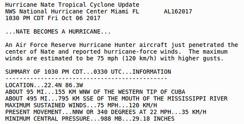
FORECAST TRACK: Hurricane Nate could pull a bit more east if it continues to strengthen. Tonight while it wrapped itself up, it to a decided jog almost north-northeast at one point.m Some of the forecast models are hinting at this.
Because Nate will interact with an upper-level low to the west, and area of high pressure to the east and a cold front to the north, it will be difficult to nail down specifics more than 12 hours out.
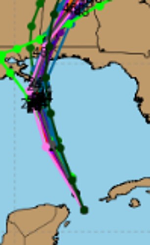
FORECAST STRENGTH: Intensity forecasts are not always the greatest with tropical systems. There is a lot about the internal physics of a developing storm that we still don’t fully understand. Because of that, hurricanes can do things that we don’t expect.
Intensity forecast model data // Courtesy: Tropical Tidbits
The SHIPS computer weather model that handles hurricane intensity forecasts puts the chances of “rapid intensification” during the next 24 hours at about a 50/50 shot – putting Nate as a high-end Category 1 or low-end Category 2 storm. More of the other models, though, continue to show a Category 1 hurricane at landfall.
SHIPS Rapid Intensification forecast model data // Courtesy: NOAA
From the National Hurricane Center
Recent data from NOAA and Air Force Reserve reconnaissance flights indicate that Nate continues to strengthen and is near hurricane strength. The NOAA plane measured a maximum 700-mb flight-level wind of 75 kt, but the SFMR instruments on both planes have only measured surface winds as high as 55 kt. It seems that the highest winds haven’t quite mixed down to the surface, but it’s likely that the system is at least producing surface winds of 60 kt, which will be the initial intensity for this advisory. The NOAA flight also reported that an eyewall is forming to the east of Nate’s center.
Most reasonable estimate of onset of tropical storm force wind & probability of tropical storm foce wind // Courtesy: NOAA
Nate has been accelerating toward the north-northwest between a large cyclonic gyre centered over southern Mexico and a mid-level high located over the southwestern Atlantic, and the initial motion estimate is 340/19 kt. This north-northwestward motion is expected to continue for the next 24 hours, with Nate turning northward and slowing down only slightly around the time it is forecast to cross the northern Gulf coast between 24-36 hours. After landfall, the cyclone is expected to get swept up ahead of a large mid-latitude trough, and accelerate northeastward over the eastern United States. At least up until landfall, the track guidance is in good agreement, and the NHC forecast is relatively unchanged from the previous one. After landfall, the new forecast is just a tad slower in order to give some credence to the slower solution provided by the ECMWF model.
Atmospheric and oceanic conditions appear conducive for Nate to continue strengthening up until the time it makes landfall along the northern Gulf coast. Nate is likely to become a hurricane overnight, and the new NHC forecast has been raised to a peak intensity of 75 kt at 24 hours based on guidance from the SHIPS and LGEM models. The intensity consensus and HCCA are lower than that due to the HWRF solution, which shows absolutely no strengthening before landfall. Disregarding that solution, it seems prudent to be above the consensus, close to the upper end of the guidance envelope. Rapid intensification still cannot be ruled out since the indices are showing a 50/50 chance of a 25-kt increase over the next 24 hours. If Nate becomes a hurricane soon, then additional increases in the official intensity forecast may be necessary in subsequent advisories.
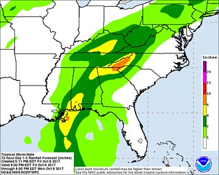
Rainfall estimate from the WPC // Courtesy: NOAA
Aircraft data indicate that Nate is an asymmetric storm, with most of the winds located on the eastern side of the circulation, and this structure is likely to continue until landfall due to the cyclone’s fast forward speed. Therefore, locations to the east of where Nate makes landfall are expected to receive significantly
stronger winds than locations to the west of the center. Regardless, there is still too much uncertainty to know exactly where landfall will occur, and all locations within the hurricane warning area should be preparing for hurricane-force winds.
KEY MESSAGES:
1. Life-threatening storm surge flooding is likely along portions of the northern Gulf Coast, and a storm surge warning is now in effect from Morgan City, Louisiana, to the Okaloosa/Walton county line in Florida. Residents in these areas should heed any evacuation instructions given by local officials.
2. A hurricane warning is in effect for portions of the northern Gulf Coast from Louisiana to Alabama, and preparations to protect life and property should be rushed to completion in these areas.
3. Nate will bring heavy rainfall of 3 to 6 inches with isolated totals of 10 inches east of the Mississippi River from the central Gulf Coast into the Deep South, eastern Tennessee Valley, and southern Appalachians through Monday, resulting in the the potential for flash flooding in these areas.
4. Moisture from Nate interacting with a frontal zone will also bring 2 to 4 inches with isolated totals of 6 inches across the lower Ohio Valley into the central Appalachians Sunday into Monday, which will also increase the risk for flash flooding across these locations.
Current watches and warnings
A Hurricane Warning is in effect for…
* Grand Isle Louisiana to the Alabama/Florida border
* Metropolitan New Orleans and Lake Pontchartrain
A Storm Surge Warning is in effect for…
* Morgan City Louisiana to the Okaloosa/Walton County Line Florida
* Northern and western shores of Lake Pontchartrain
A Tropical Storm Warning is in effect for…
* Punta Herrero to Rio Lagartos Mexico
* Pinar del Rio Cuba
* Lake Maurepas
* West of Grand Isle to Morgan City Louisiana
* East of the Alabama/Florida border to the Okaloosa/Walton County Line.
A Hurricane Watch is in effect for…
* Lake Maurepas
* East of the Alabama/Florida border to the Okaloosa/Walton County Line
* West of Grand Isle to Morgan City Louisiana
A Storm Surge Watch is in effect for…
* East of the the Okaloosa/Walton County Line to Indian Pass Florida
A Tropical Storm Watch is in effect for…
* East of the Okaloosa/Walton County Line to Indian Pass Florida
* West of Morgan City to Intracoastal City Louisiana
* Isle of Youth Cuba
A Hurricane Warning means that hurricane conditions are expected somewhere within the warning area. A warning is typically issued 36 hours before the anticipated first occurrence of tropical-storm-force winds, conditions that make outside preparations difficult or dangerous. Preparations to protect life and property should be rushed to completion.
A Tropical Storm Warning means that tropical storm conditions are expected somewhere within the warning area.
A Storm Surge Watch means there is a possibility of life-threatening inundation, from rising water moving inland from the coastline, in the indicated locations during the next 48 hours. For a depiction of areas at risk, please see the National Weather Service Storm Surge Watch/Warning Graphic, available at hurricanes.gov.
A Hurricane Watch means that hurricane conditions are possible within the watch area.
A Tropical Storm Watch means that tropical storm conditions are possible within the watch area, generally within 48 hours.
Author of the article:
Nick Lilja
Nick is former television meteorologist with stints in Amarillo and Hattiesburg. During his time in Hattiesburg, he was also an adjunct professor at the University of Southern Mississippi. He is a graduate of both Oregon State and Syracuse University that now calls Houston home. Now that he is retired from TV, he maintains this blog in his spare time.