For nearly every spot on the Earth, the cloud cover and the wind dictate the temperature. A lot. 24 hours per day. Seven days per week. Every day of the year – all 365!
Yeah, the Sun may be the main driver of general heating of the entire planet, but once you get down the the specifics and want to hone in on a single point… it ain’t the Sun doin’ the work!
What gives?
Heat Transfer FTW!
The same subject in physics that brings us summer time storms is the same thing that helps us get pretty chilly on autumn and winter nights: Radiation.
No, not THAT kind of radiation. No one will be glowing.
Radiation is the type of heat transfer.
Because light is a wave, radiation is a form of heating via electromagnetic waves. Electromagnetic waves are really cool because unlike sound waves, EM waves do not need molecules to propagate, they can work in a vacuum. And, just like light, EM waves move at a constant speed of nearly 300,000 km (186,000 mi) per second. And they come in a bunch of different types – from radio waves to X-ray waves.
The shorter the wavelength, the more energy it can carry! The more energy something can carry, the more heat it can create.
I know what you’re thinking: That’s great Nick, but can you please explain just how that helps cool down places where there is no cloud cover and very little wind?
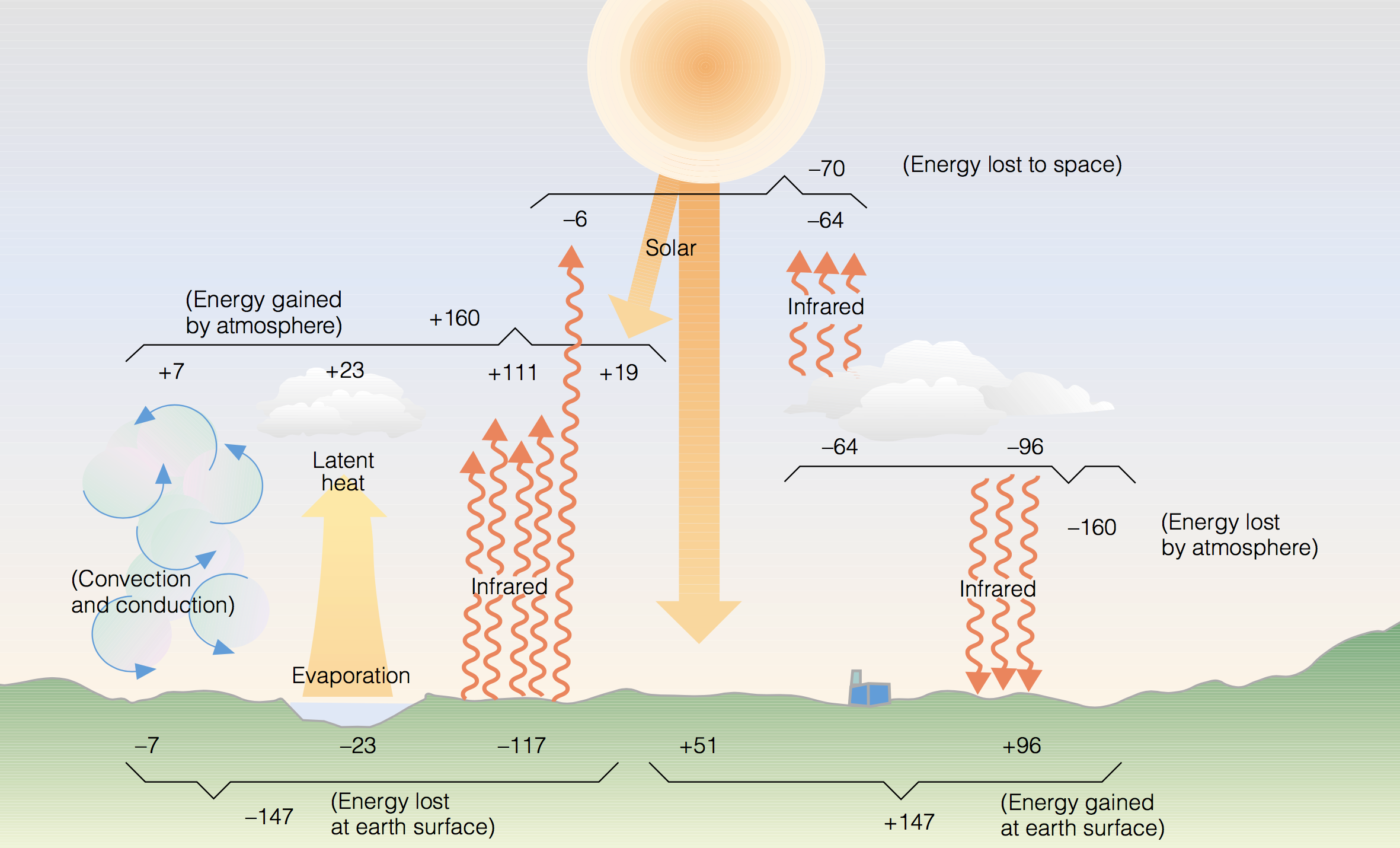
The short answer: Heat resulting from the absorption of incoming shortwave radiation (sunlight) is emitted later as longwave radiation and absorbed by things in the atmosphere (clouds, water vapor, CO2, and other stuff).
But, dude, how does it work?
Glad you asked! After the sunsets, the air near the ground starts to cool faster than the air above ground. This happens for a few reasons, a lot of which have to do with the Earth’s energy balance.
A few take home points…
1. Air is a poor conductor of heat energy.
So, as an example, let’s look at a bunch of copper pipes. The copper pipes will cool down quickly (since they are good conductors of heat), while the air above the pipes cools a little but the air much above remains at about the same temperature. Now consider, instead of this small localized example, if everywhere on earth this was happening because a lot of things on the ground are better conductors of heat than the air.
So, the air temperature cools nearest the ground, but above it – by as little as a few hundred feet sometimes – doesn’t cool as fast.
2. As the ground emits longwave infrared radiation at night, that is collected and trapped by gasses in the air.
As it turns out the stuff in the air is really good at trapping heat from longwave radiation. Longwave radiation is the same thing used in Night Vision Goggles – infrared! On nights with more humidity or cloud cover, the water vapor in the air absorbs this longwave radiation – but even on dry nights it can happen, too. Other things in the air absorb this longwave radiation, too. Things like Carbon Dioxide, Nitrous Oxide, Methane, etc.
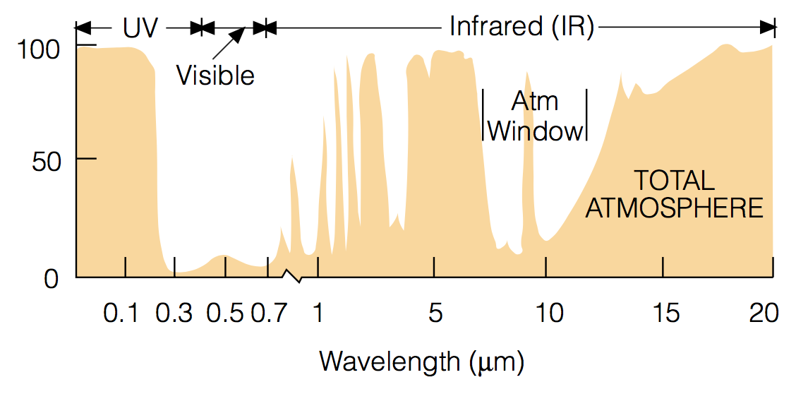
The above image is a look at the absorption rate of longwave radiation by the atmosphere. Notice as the wavelength gets longer, there is more absorption.
3. The wind mixes up the air, keeping the previous two things from cooling down the air as easily.
Imagine a scenario where a car is parked in a parking lot. The air was cooling rapidly near the ground, but a gust of wind came through and moved the cold air out and replaced it with warmer air again. And every few minutes this happened. Would the temperature of that car and the surrounding area ever get much cooler? Probably not.
Plus the wind mixes the air vertically, too. That means that the warmer air above the surface can be mixed down, too. Further keeping the air temperature warmer.
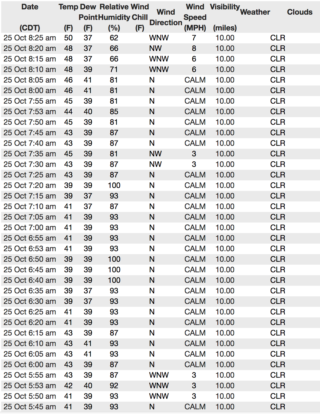
A perfect example of this is the image to the right. Between 5:55am ( when the wind calmed down) and 7:20am the temperatures fell from 43F to 39F. But once the wind started moving again at 7:25am through 7:35am, the temperature rose from 39F to 45F
4. Clouds are made of water so they absorb some longwave infrared radiation but also re-reflect it back to Earth, too.
Remember that whole “heat resulting from the absorption of incoming shortwave radiation is emitted as longwave radiation” thing? Turns out that the longwave radiation, LWR, being emitted is easily gobbled up – or reflected back to earth – by the water vapor in clouds.
So if there are clouds, they tend to act as a blanket on the atmosphere, keeping it warmer at night. No clouds? No blanket! No warmth.
But cold air sinks. Right? So how does it every get colder higher up?
It does! That explains why valleys can be a bit cooler than other places. But sometimes cold air runs into other cold air and is bounced upward, this can cause other air to be pushed up, too. Or down. Or over. But because the whole atmosphere is connected, every movement of air has a chain reaction is every direction.
That is why it can be very difficult to predict the temperature of a specific point overnight (or anytime, really). Because things are – seemingly – insignificant as how many cars are parked on a street can dictate how cool it is at your front door.
But so long as you have no wind to stir up the air, there isn’t much moisture in the air, and there aren’t any clouds, you’re set up for a great night to watch the thermometer tank.
And this also explains why it can actually be colder the night after a cold front passage. Because when a front swings through it is usually cloudy and windy. So even though the air is cold, the longwave radiation is trapped at the surface and the air is constantly being mixed up. But the NEXT night, when the clouds clear out and the wind dies down, the air can get that much colder!
Neat stuff, huh?


