Maybe, yeah.
If you are a weather enthusiast you have probably read about the cold air that is going to cascade into the Lower 48 next week. You have probably also read about the lobe of cold that will slam into the south, too.
If you are not a weather enthusiast and are just hearing about this… buckle up.
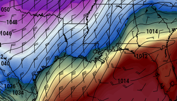
The idea is that a large slug of cold air may make the trek from Siberia, mix with some western Canadian air (also, not warm) and come plunging into the States. Something called a “1040 Ridge” of high pressure may park over parts of the lower Mississippi Valley and hang out for a couple of days leading to some cold days – and very cold nights.
How cold you talkin’ bout, Nick?
Well, the specifics are still up in the air, but it could be anywhere from oh-hey-this-it-is-very-cold type of cold… to… it-hasn’t-been-this-cold-in-a-decade type of cold.
A quick note: This forecast is for the Gulf Coast areas mainly south of I-20
It is winter, so this isn’t surprising, I suppose. And before I start to lament the national news outlets really play this one up, I want to pause for the cause: If things do shake out to be as cold as they could be, it would be very important to make plans to be able to stay warm – where ever you are – if you lost power / ran out of gas in your car.
Back to the forecast, though.
This will likely change a bit in the coming days, as it is generally to early to nail down specifics. But I want to stress that it will feel like winter for a lot of us next week.
It is the degree of winterness is the part we are still trying to figure out.
Here is what we are thinking so far…
Sunday, New Year’s Eve
Not much to write home about. Temperatures will be in the upper 40s to low 60s – depending on location. Showers – and perhaps even a rumble of thunder – will be the name of the game for Texas, Louisiana, Mississippi, Alabama and the Florida panhandle.
Sunday Night
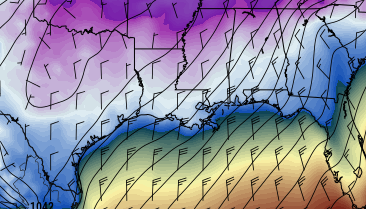
Things get tricky here. Behind the front that is moving through the rain will switch to sleet and freezing rain. And I understand the desire to know what your town will be dealing with specifically and what time is important. But, because we are so far out, specifics are unknowable. The best we can offer right now is that the line for change-over around midnight – as the ball drops – could within 50 miles of places like Lake Charles, LA, Baton Rouge, LA, Jackson, MS and up toward Birmingham, AL.
The impacts form this will not be known for another few days as the development of the front hasn’t happened and we still need to get a handle of how moist/dry everything will be. Because the impacts of this will depend on the speed of the front and the available moisture, it is tough. If it slows down, the front – and cold air – arrive later. If it speeds up, the cold air gets there quicker. And there is a chance that the front moves through and there is so little moisture to work with that drizzle is all it will muster.
Monday
The moisture leaves the area in the morning. And the day looks to be mostly cloudy and cold. Just how cold? Sadly, because it is so far out, this is one of the specifics that can’t be known yet. But generally temperatures will range from the upper 20s to the low 40s. Region-wide. Warmer along the coast, much cooler as you approach I-20.
Monday Night
This is where the real cold starts. As that “1040 Ridge” from earlier drops into the Mid-South and the cold air it brings with it really takes hold.
Overnight lows on Monday night and into Tuesday morning could – and I stress could, not will – be the coldest the region south of I-20 has seen in the better-part of the last few years. Perhaps longer.
Lows region-wide will be – at least – as cold as 20 to 30 degrees. Places like Houston, TX, Lake Charles, LA, New Orleans, LA, Mobile, AL, Tallahassee, FL might see temperatures dip to around 25 to 30 degrees overnight. And, at this point, we can’t rule out the possibility that some places inland – like places near or around Baton Rouge, LA, Jackson, MS, Montgomery, AL – will be even colder, in the teens.
North of I-20 places could be down into the single digits.
Tuesday
Things look cold during the day with many places struggling to get out of the 30s and low 40s. The cold air should start to modify (warm up) and shift eastward a bit during the day.
Tuesday Night
Temperatures may again fall back into the 20 to 30 degree range for a lot of the same places. And inland may have another battle with the teens in some spots and the cold air modifies.
Wednesday
Things start to warm up more. Highs above freezing and in the 30s and 40s region-wide – even inland.
Thursday
Still cold, but getting back to normal.
So what can still change?
Pretty much everything. Not going to lie. However, I want to stress that – in general – it will be a lot colder next week. The Analogs, the upper-air patterns, the forecast model data, and the teleconnections all point to WINTER IS COMING for the United States.
What we are still working to figure out is, ‘just how much winter?’ and ‘will there be any moisture when winter shows up?’
So what do I do now, Nick?
Keep checking the forecast every day. As we get more and more data, we will be able to refine the forecast about every 12 hours. And check your emergency kit! It is always a good time to do that. Especially when adverse weather is on the horizon.
Make sure you have…:
- Water – one gallon of water per person per day for at least three days, for drinking and sanitation
- Food – at least a three-day supply of non-perishable food
- Battery-powered or hand crank radio and a NOAA Weather Radio with tone alert
- Flashlight
- First aid kit
- Extra batteries
- Whistle to signal for help
- Dust mask to help filter contaminated air and plastic sheeting and duct tape to shelter-in-place
- Moist towelettes, garbage bags and plastic ties for personal sanitation
- Wrench or pliers to turn off utilities
- Manual can opener for food
- Local maps
- Cell phone with chargers and a backup battery
- Extra blankets available for your bed so you can sleep in the colder temperatures.
- Enough fuel in your propane grill just in case you want to cook and you don’t have power
- A full charge on those portable phone charger bricks (if you have one)
Other things to consider….
- Prescription medications
- Non-prescription medications such as pain relievers, anti-diarrhea medication, antacids or laxatives
- Glasses and contact lens solution
- Infant formula, bottles, diapers, wipes, diaper rash cream
- Pet food and extra water for your pet
- Cash or traveler’s checks
- Important family documents such as copies of insurance policies, identification and bank account records saved electronically or in
- a waterproof, portable container
- Sleeping bag or warm blanket for each person
- Complete change of clothing appropriate for your climate and sturdy shoes
- Household chlorine bleach and medicine dropper to disinfect water
- Fire extinguisher
- Matches in a waterproof container
- Feminine supplies and personal hygiene items
- Mess kits, paper cups, plates, paper towels and plastic utensils
- Paper and pencil
- Books, games, puzzles or other activities for children
Those are all things you should consider for your emergency kit. Not that THIS time is going to be an emergency, necessarily, but it is always important to make sure you have your kit, ready to go, just in case.


