No big change to the forecast. Latest from the NAM, GFS and the ECMWF still show a chance for some rain on Sunday. The models still show a chance that the rain mixes with sleet. Still shows the cold – and very dry – air swings in overnight Sunday and into Monday.
A quick peek
Here is a look at the NAM-3km composite reflectivity data. This is what the model thinks the radar will look like during the day on Sunday.
[slide-anything id=”28434″]
It shows a very disorganized area of light rain passing through Louisiana, Mississippi and Alabama between 7am and 7pm. For south Mississippi, by the early afternoon, the rain may mix with sleet pellets, but the overall impacts should remain negligible due to the air temperature above freezing – though, not by much with temperatures around 35 to 40.
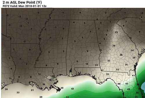
Once the rain/sleet ends, then the temperature will cool back into the upper 20s. And a lot of cold dry air starts to drape across the area. Dewpoints by Monday morning will be in the single digits. So get ready to be shocked – literally, by electricity – by everything that can hold a charge.
It isn’t like last time
A lot of people have asked about snow, and that is sadly not in the cards this time. The atmosphere is setup for sleet and cold rain as opposed to snow. Looking at the forecast soundings, it shows that the temperature will be around 50 degrees up at about 4,000 feet. And the dendritic growth zone will be too dry.
Take a look at the different soundings, this time vs. last time
[slide-anything id=”28432″]
Last time, the atmosphere was saturated from top to bottom, we just weren’t sure if there would be enough forcing.
This time, the atmosphere is only saturated from – roughly – the surface up to 5,000ft. And between 1,000ft and 5,000ft th temperature will be above freezing.
Then it gets really cold
A lot of people make fun of me for not knowing when it is really cold outside. I tend to call the 30s “chilly” while everyone else says it is “very cold” outside.
Well, this shot of cold air will be “pretty cold” even for me.
Temperatures will slide back into the teens and 20s overnight Monday into Tuesday and Tuesday into Wednesday. And there is a chance that it may happen again Wednesday and into Thursday and again Thursday into Friday.
That is a full week of overnight lows below freezing. And most nights temperatures will be down to – at least – 25 degrees.
Ad that’s not all. During the day, we won’t be getting terribly warm. Highs in the afternoon will likely struggle to tag 40 – if they even get out of the 30s.
Brief forecast
Sunday
Cloudy with hit and miss showers. Rain may mix with sleet after 3pm. Precip chance around 40 percent with rain totals around 0.15″ to 0.40″ by 9pm. Temperatures will top out around 35 in the early afternoon. Temperatures drop quickly at night.
IMPACTS: Wet roads, cold temperatures, nothing icy
Sunday night
Lingering light rain showers may mix with sleet, but snow and freezing rain aren’t as likely. Rain chance around 20 percent. Temperatures below freezing by midnight when the ball drops. Overnight temperatures will drop to the 20s. Rain totals will be less than 0.10″ during this timeframe.
IMPACTS: Wet roads, cold temperatures, some elevated – less traveled – surfaces may be icy
Monday morning
Any lingering precipitation will fall as sleet. Rain chance around 10 percent. Temperatures will be in the mid to upper 20s. Precipitation totals will be less than 0.10″ during this timeframe. The good news is the air that is moving in is very dry. That should evaporate a lot (but not likely all) of the moisture on the roads.
IMPACTS: Below freezing temperatures, some elevated surfaces may be icy
Monday
Clearing skies, with temperatures climbing to around 35 degrees. Rain chance less than 10 percent. Any wet areas should dry up. No precipitation anticipated at this time.
IMPACTS: Cold temperatures


