Your app isn’t necessarily lying to you. Our mid-range models are starting to come together, showing a chance for wintry precipitation across parts of South Mississippi next Tuesday and Wednesday.
Right now, it looks like more colder air will get here on Tuesday and then back in behind the cold air, some precipitation will roll through, too.
That is really weird for us, but not unprecedented (remember December 8th?).
What we know
There will be cold air. There will be precipitation.
And at this point, that is about it. I know that isn’t much, but we are still four days away from the chance that there is precip and cold. Either one of those things could change, and even a slight change to either, will be a big change to the other.
Does that make sense? I think I even confused myself.
Anyway, you may start to see crazy snowfall maps pop up on social media, but nothing is going to be nailed down until – at the earliest – Sunday night or Monday morning.
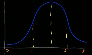
The ensemble model data are still showing between 0″ (yup, there is still a chance for that) and, as many as, 5″ of snow. The operational models are showing between 0.5″ and 1.5″ of snow possible.
But, all of this will be watched closely because generally around here the precip tends to dry up once the cold air arrives. Why is that? The colder air is often VERY dry by the time is gets here, so any moisture that was in the air to make snowflakes, drys up and we don’t get any snow.
But given this winter, almost anything seems possible.
What we don’t know
We don’t know how much snow there will be or how the precipitation will develop. How the precip develops will really dictate how much we see – and who sees what.
And almost everything else, too.
What we can’t know
What will change between now and then. Because of that, there could be some slight changes in the small details that mean BIG changes to the forecast (snow vs. no snow).
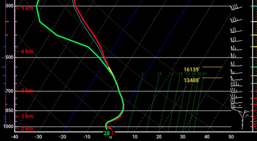
For example, the Skew-T below is showing a fair amount of snow being made in the DGZ, the column is moist from top to bottom, meaning no snow will sublimate (evaporate from ice to gas), and the entire column is cold meaning it makes it all the way to the surface.
That said, another option may look like this:
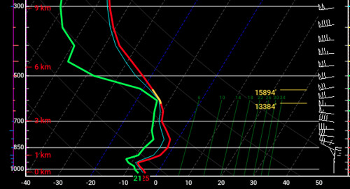
Snow would be created, but some of it would sublimate on the way to the ground. That would mean less snow.
What can you do now?
Keep hoping (if you want snow) that the forecast doesn’t change. And keep the coats handy. Even after the chance for snow passes, there will be some mighty cold air settling in for night or two afterward.


