New data now shows an increase in the chance for snow across South Mississippi, but the range of possible totals is slimming down a bit. Also, the new data suggests less of a chance that the precipitation starts as anything other than snow, which isn’t a common occurance for the Gulf Coast at all.
The big change is the timing of the snow. More on that below.
Forecast
It still looks like December 8th will be the big winner this winter for snowfall. This round of snow will feel like bad dandruff compared to the constant flow of flakes last month.
We are still following the same story, though. As the cold front dives through the area, it will drop light amounts of snow.
A Winter Weather Advisory is now in effect for most of the Mississippi counties south of I-20 from 9am Tuesday until Midnight. That means the National Weather Service is concerned about up to one-inch of snowfall.
There shouldn’t be any widespread travel problems south of I-20 on the main roads. That said, the roads will be wet and slick, and perhaps icy on bridges and overpasses. So if ou are going to be traveling, please slow down on the roads.
Snow totals will be between nothing (just snow in the air) and about two inches. Some of us will see enough snow to accumulate, others will see just flakes.
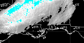
The best bet for snow, sticking and accumulating, will be north of the Highway 84 corridor. There will still be patches of sticking snow, accumulating north of Highway 98, but it won’t be as widespread.
And kids, I’d recommend you do your homework tonight and tomorrow night. I anticipate that very few – if any schools – will close. More on that below.
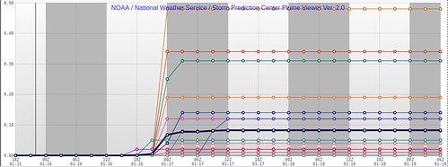
The graph shows estimated snowfall totals from the SREF. The main takeaway is that there are more lines (better chance for snow) but the lines don’t go as high (lower estimated snowfall totals).
Timeline
The model data is really starting to speed this thing up. Snow could start as early as 11am for some, but most of us will have to wait until after lunch for snow. The flakes will fly, here and there, through the evening. Most of the snow should be over by 10pm.
I do have one concern: The models continue to speed this thing up. That could mean that some snow could be around for the morning commute. While this won’t be heavy snow, nor do I expect it to hamper travel much, it would be a distraction for drivers, leading to more accidents.
More snowfall estimates
Notice in the graph below that there is almost an equal chance that we see around 0.1″ of snow and 0.75″ of snow. The most likely scenario is between 0.25″ and 0.5″ of snow. And there is about a one-in-three chance that we see 1.0″ of snow.
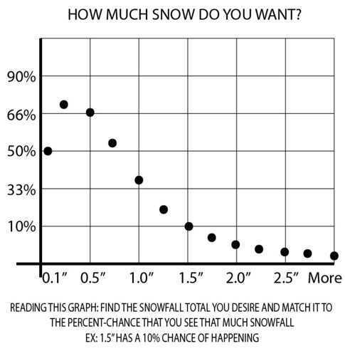
Most model data is now leaning more toward the 0.0″ to 1.0″ snow totals. Any rogue model data from earlier today and previous days has come in-line with everything else.
This will be – just like every time it snows down here – a tough forecast to nail down. Please keep checking back for updates.
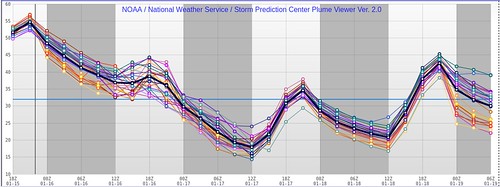
Whatever falls, won’t be the big story, though, as the front will cool us back down (pretty cold, too). Tuesday night it will get back into the 20s – wind chill values in the single digits. Wednesday we will barely pass the freezing mark for a high. Then Wednesday night we will be down into the teens.
Impacts
PETS: After they play in the snowflakes, bring ’em in at night! Temperatures will be quite cold Tuesday night and again Wednesday night. No need for your pets to be outside in this kind of cold.
ROADS: There shouldn’t be widespread problems south of I-20. Some county roads, side streets and alleys will probably be pretty slick/icy at times, and overpasses and bridges will be, too. But, generally, the well-travel pavement (main roads, highways, etc) should remain mainly wet, not icy (except bridges and overpasses, of course). Then, given how dry the air will be behind this front, the roads will simply dry up.
SCHOOLS: There shouldn’t be many problems for schools on Tuesday morning. However, Tuesday afternoon may be a different story for some county roads. Given that less-travel roads and all bridges will tend to be a bit more apt to see sticking snow and/or ice, there may be some buses that can’t make certain routes.
This may also lead to some schools delaying start on Wednesday due to these conditions.
Also, it will be pretty cold out at the bus stop for kids. Make sure they are good and bundled up as they head out the door. Dress ’em up in layers if they refuse to wear a coat. I know I used to wear, like, three sweatshirts and two pants to school in Wisconsin as a kid.
BUSINESSES: Depends on the business, but the roads shouldn’t hinder anyone from getting to work – eventually. Much like the schools, some may have to open a bit late if employees are coming in from county roads.
POWER: Given it will be all snow, and the amounts should be pretty light, this would be a pretty isolated problem. Widespread power outages are not anticipated. If you end up without power, crews should be able to get on the problem pretty quickly.
WATER: The low temperatures after the snow will be down into the low 20s Tuesday night and into the teens Wednesday night, so dripping a faucet will become necessary for folks with elevated foundations or in mobile homes. If you have a single floor cement foundation home, opening cabinets below the sinks should be enough to faucets on the interior section of the home, but dripping any faucets where pipes are near an outside wall might be a good idea.
GAS: Shouldn’t see any impacts here as temperatures aren’t going to be cold enough to freeze lines.
OTHER PREPS: Always good to make sure you have some extra blankets on the beds and double check outdoor spigots. Make sure you’ve got a way to keep warm for a while should the power go out.


