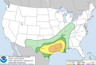
A line of showers and storms is going to press across parts of Louisiana, Mississippi and Alabama between Halloween afternoon and into November 1st. Along the line, showers are a guarantee, storms will be likely, and severe weather will be possible.
There is a better chance of seeing severe weather across parts of Texas and Louisiana on Halloween, but into the overnight hours and through November 1st, that threat stretches east as the line of storms moves from NW to SE and into the Gulf of Mexico.
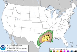
Nerdy details from the SPC
In mid/upper levels, a series of shortwave perturbations now located from northwestern BC to the Four Corners states will shape the eastward shift of synoptic troughing across the central CONUS today and tomorrow. A strong, basal shortwave trough — now evident in moisture-channel imagery from southwestern CO across eastern AZ — is forecast to move east-southeastward by 00Z to southeastern CO, south-central NM and northern Chihuahua. By 12Z, this trough should pivot eastward and become less positively tilted, reaching west-central KS, northwest TX and northern Coahuila. An initially separate, weaker, southern-stream perturbation — currently crossing central Baja and adjoining Gulf of California — will eject east-northeastward across northern MX today, its northeastern fringes reaching south-central TX this evening, before further deformation and weakening of its vorticity field occurs.
Surface analysis showed a cold front from eastern MO across western AR and north-central TX, becoming a wavy/quasistationary boundary over parts of the northern Hill Country and Edwards Plateau regions to the lower Pecos Valley. As heights fall aloft with the approach of the strong southwestern CONUS trough, a weak frontal-wave low should develop over east-central TX mid-late this afternoon, with cold front southwestward across south-central TX into northern Coahuila. The low should move northeastward over the Arklatex region this evening, across AR into the MO Bootheel/extreme western KY region by the end of the period. By that time, the front should reach southeastern AR, south-central/southwestern LA and the shelf waters off the mid/upper TX coast.
…TX to lower Mississippi Valley…
Near the leading edge of the large-scale ascent plume preceding the mid/upper trough, a plume of convection is gradually strengthening over west-central TX between ABI-MAF. This activity may offer severe hail over the next few hours, and the potential for damaging wind will increase with proximity of its southern portions to the front and adjoining warm sector. See SPC mesoscale discussion 1599 for more details.
With persistence and eastward shift of the associated mid/upper-level vertical-motion plume, and as the surface frontal zone impinges on a diurnally destabilizing warm sector, the morning convection should persist eastward, expand, and intensify through the day. With flow aloft largely parallel to the frontal zone, expect evolution into a broken to solid, quasi-linear configuration with embedded bow, LEWP and supercell features. Additional thunderstorms are forecast to develop and grow with time from midday through afternoon over the weakly capped warm sector in east and southeast TX, along low-level convergence/confluence axes. Both processes will occur amidst strengthening mid/upper winds and continued boundary-layer warming and moisture transport.
Accordingly, a gradual ramp-up in severe potential is expected, amidst buoyancy/shear parameter spaces favoring the entire spectrum of severe hazards. Where low- and middle-level lapse rates will be greatest, overlapping with the western rim of richest low-level moisture, a narrow plume of 2000-3000 J/kg prefrontal MLCAPE should develop this afternoon over central/south-central TX, decreasing gradually eastward and sharply along and behind the front. MLCAPE 500-1000 J/kg should prevail tonight over the LA/MS portion of the outlook area, weaker but still with sufficiently unstable surface-based parcels to support the outlined severe threat.
Though winds aloft won’t be quite as strong across southeast TX and LA this afternoon/evening as farther north/west, more-backed surface winds should help to enlarge both hodographs and the storm-relative surface vector. Effective SRH in the 150-300 J/kg range should become common, increasing this evening into overnight over LA and central/western MS near a 50-60-kt low-level jet. This will boost the tornado risk for any relatively sustained/discrete supercells, and even for line-embedded storms. Such an environment supports the somewhat conditional potential for strong tornadoes, with storm mode being a major influence on their number and longevity.
A separate round of thunderstorms may develop late this afternoon and this evening over parts of southwest TX near the Rio Grande and lower Pecos River regions, and over the Serranias del Burro range of Coahuila. Severe hail/gusts will be possible from this activity as it tracks eastward across parts of southeast and south-central TX, with wind more probable along and south of the front inmore-unstable boundary-layer air.
Graphically speaking (but still nerdy)
Here is a look at some of the model output for this event…
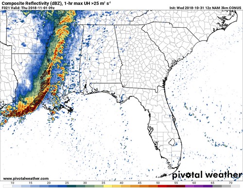
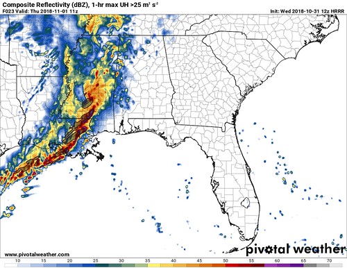
Now the fun part! Of the two, which one is right?
Neither.
Sadly, no model data is going to pinpoint the forecast exactly. But what we can pull from both of these is that the greatest threat for severe weather will likely be along and just in front of the line of storms. And model data suggests that line of storms will begin to enter our area between 1am and 4am, and be out of here no later than 10am.
What do we know about the atmosphere as the line passes? Great question!
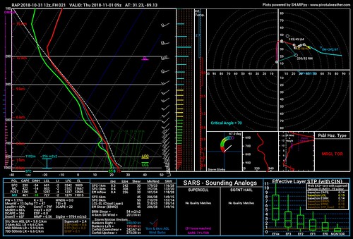
According to the 12z RAP data, the atmosphere will be conducive to develop and sustain severe storms across most of South Mississippi, with the cutoff between enough instability and not enough instability being roughly I-20. If you live south of I-20, there will be enough instability to get storms to turn severe.
Further, the helicity and shear values are more than ample for the development of severe storms.
Compare those numbers above to these numbers:
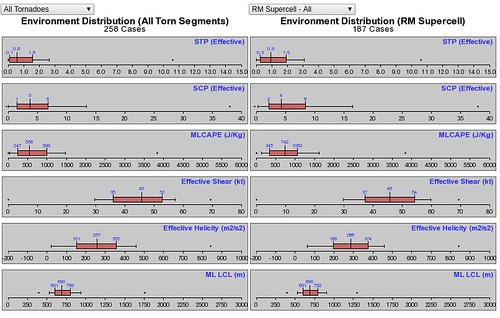
When numbers in soundings from the model data show similar values to historical numbers that produced severe weather in the past, it is a pretty good bet that there is a chance for severe weather to occur.
And as the storms pass, here is a look at what one model thinks the atmosphere will look like:
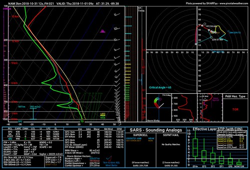
Notice how many numbers line up with historical values. Basically every single one.
The Timeline
Here is a rough timeline of events given the available data as of 10am on 10/31/18…
12am – A few showers and storms may develop across parts of Walthall, Lawrence and Simpson counties.
2am – The line of storms starts to move through parts of Walthall, Lawrence and Simpson counties. Isolated showers and storms will be possible across parts of Smith, Jasper, Covington, Jeff Davis, Marion and Lamar counties.
4am – The line of storms starts to move through parts of Smith, Jasper, Covington, Jeff Davis, Marion and Lamar counties. Isolated storms begin to develop ahead of the line in Clarke, Wayne, Jones, Forrest, Pearl River, and Stone counties.
6am – The line of storms starts to move through Clarke, Wayne, Jones, Forrest, Pearl River, and Stone counties. Isolated storms develop in Greene, Perry and George counties.
8am – The line of storms starts to move through Greene, Perry and George counties.
10am – Storms clear the area
The Bottom Line
Based on the available data there is a chance for severe weather as the line of storms mentioned above moves through South Mississippi. The main concerns are for heavy rain, localized flooding (up to 4 inches of rain), frequent lightning, gusty to damaging wind, small hail and the possibility of a tornado or two.
Does that mean guaranteed severe weather? Or guaranteed tornadoes?
No.
But it does mean that the atmosphere is capable of producing and sustaining severe weather – as well as tornadoes – tonight and into tomorrow morning. So it is important to keep an eye on the weather. Have your NOAA Weather Radio nearby, with batteries. Have a trustworthy weahter app that will send you alerts on your phone. Watch the news tonight to get the latest available forecast information, too.


