Before you get bombarded with the cries of Snowmageddon, Arctic BLAST-O-RAMA, or the SOOPER DOOPER POLAR VORTEX OF COLDER-THAN-MARS TEMPERATURES, please allow me to clear up some confusion, calm the hype and give everyone the straightforward ‘what we actually know at this point’ batch of information.
The polar vortex has fallen apart, which could unleash a much colder end to January: https://t.co/CbiWWkp9tC pic.twitter.com/5L61eAmM6E
— The Weather Channel (@weatherchannel) January 13, 2019
The Polar Vortex fell apart?! Just, stop.
Statistics, Math and What to watch out for…
Math isn’t as difficult as people make it. Neither is Statistics. Promises of specifics on a forecast that calls for numbers 1.5 to 3 standard deviations from the mean is aggressive.
As I said about the snow in Pine Belt last year, it is difficult to predict weather that is significantly anomalous. One to two standard deviations from the mean isn’t that crazy. Two to three starts to get reasonably significant. Three to five is pretty crazy.
So, when meteorologists start offering specifics on a forecast – this anomalous – eight to 13 days from now?
That is gutsy.
And some people are already running with it. Others are sprinting off a cliff.
BREAKING: Arctic air IS on the way to the Gulf Coast and it may arrive as early as next Sunday/Monday. Also *possible* across central Alabama and Georgia… SNOW SHOWERS! https://t.co/eiKrlaEzyx pic.twitter.com/ScKi7eID3f
— Jake Dunne, MS (@Jake_WPMI) January 13, 2019
Now it isn’t just cold, but snow? I know the counter-argument, too, “but I say ‘might, could, or maybe’ in my tweet, Nick!”
That’s your deal, I guess. And I’ll get back to why that is bad later. Just don’t be the person who, if someone sees as much as a single flake, posts, “I called it!”
Okay, back to the data.
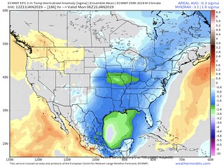
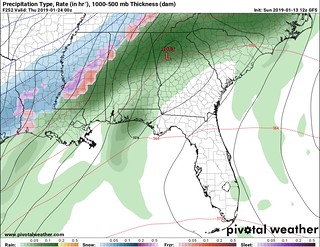
The model data image above (not the tweet, the model data) shows the temperature normalized against average. The colors suggest the chance that in the south there will be temperatures between one to three standard deviations from the mean below average.
That is cold. But that is also seven to eight days from now.
Before I go any further, I love James Spann. He is a great human. Posting his tweet here isn’t a dig at him. What I will say, though, is I think this tweet might be a bit ahead of itself – especially by those who will not read it carefully.
An Arctic Blast is a week away for the Deep South. Temperatures will likely climb into the 60s Thursday-Saturday with occasional showers. The cold front moves through Saturday night, and on Sunday some North Alabama communities could say below freezing all day. Teens by Monday AM pic.twitter.com/m5s7ukzUjt
— James Spann (@spann) January 13, 2019
What this says is that it will be colder next week, with a chance temperatures are below freezing all day, and a chance lows could be in the teens.
So what can we pull from this?
Cold? yes.
Very cold? Probably.
Lows in the teens, cold? Stuck below freezing all day? Could happen.
No promises. No guarantees. However, I know many that will take it as such. This is why using qualifying words with cold and snow forecast information makes me uneasy.
For the record, that kind of cold would be like Jan 1/2 of 2018. Twenty degrees below average for his area. That also means James thinks the model is under-selling the cold a bit since the model he posted showing about 18 below average in his area.
For other places like Memphis, Atlanta and Louisville temperatures will be between 15 and 25 degrees below average.
But that is only one ensemble model. Let’s look a bit deeper.
What the data shows
The ECMWF Ensemble model data posted above in Spann’s tweet, shown on-air by The Weather Channel (I was told, I did not see it), and posted above by me shows that cold air will sag south in the United States early next week.
WeatherModels.com, run by Ryan Maue, has a ton of great European Model data that can tell a similar story in a lot of ways.
Here is a look at the same model as above showing the percentage of members of the ensemble that a temperature is below 20 degrees for next Monday morning, January 21st.
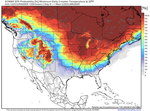
That shows 30- to 50-percent of the ensemble members have temperatures are in the teens in Spann’s area. That is a decent chance among the ensemble members. Almost a coin-flip for some parts. Only one-in-three shot for others.
Notice that chance is the same for Atlanta, Jackson, Mississippi and Little Rock, Arkansas, too. That is real deal cold. Because a 30-percent chance that temperatures are in the teens is more than doubled when you ask the percent-chance temperatures will be below freezing.
That chance? More than 80-percent.
Again, though, just one ensemble model.
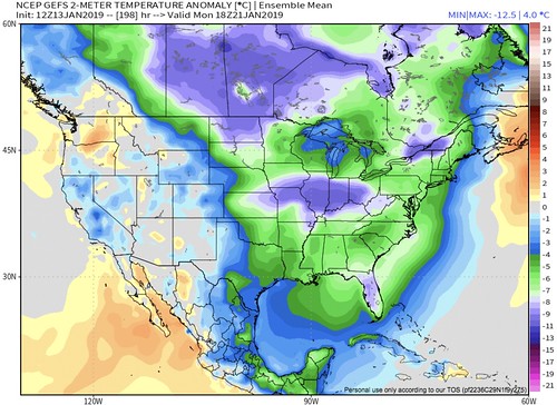
The GFS Ensemble data shows something similar, but not quite as low.
While there isn’t a percent-chance e can look at the percent-chance that the temperature is below freezing in the South using the CIPS Analogs
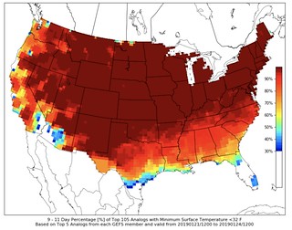
Remember that the CIPS Analogs isn’t counting how many members of the ensemble show temperatures below freezing. The CIPS is comparing all members of the ensemble against what happened historically in similar situations to what the ensemble is suggesting.
That means it should paint a more accurate – although less precise – description as to what to expect from the weather.
In this case, it too suggests a really good chance that a lot of the South endures temperatures below the freezing mark. That is to say, historically in a similar situation, places like Baton Rouge, Hattiesburg, Dothan and Macon dropped down to below freezing more than 70 percent of the time.
Or in other words, three out of every four times this type of thing happens, it freezes.
But what about the snow, Nick?
It is too early to know anything. And, as a meteorologist, saying anything else is a lazy attempt to excite your following and get clicks.
Look, I could load this site up with ads and write a post about all of the scenarios that could produce snow in the South. I could post a link on facebook and twitter with a cool map and a link. It would get shared a billion times.
I could make a few hundreds bucks in ads. Cool.
But then I would be feeding the Misinformation Monster. And I don’t want to do that. But some do.
CIPS analog temps and GEFS 16 day snows pic.twitter.com/sckbNdb6tN
— Joe Bastardi (@BigJoeBastardi) January 13, 2019
Yes, the model does show snow. But guess what. I’ve been keeping stats. Just how often has a model shown snow in, say, Hattiesburg, Mississippi as a for instance, this winter?
Well, when looking at model data for days 8 through 16, since November 28th, either the European Ensembles or the GFS Ensembles have had members showing snow 30 of 46 days.
Thirty!
That is more than three out of every five days the model data says it will snow in Hattiesburg between 8 and 16 days out.
How many days has it snowed?
None. Zero. Zip. Zilch. Nada. The big goose egg. A nothing-burger sandwich with extra nope.
So, pardon my lack of excitement or desire to hype up something without legitimate cause for concern.
But this time it is different, Nick! You’ll see!
That isn’t entirely false. And I’m not saying it won’t snow. I’m not saying it won’t be cold. All I’m saying is that it will be cold, the specifics of that cold are still a bit muddy. And snow isn’t impossible, but saying it might snow is a lazy attempt at getting clicks.
So, what is different this time for the South? The DoubleShot
Round one, on Saturday, will feature an area of low pressure well out-ahead of the cold air. And the flow along and just ahead of the front will be a bit more from the west or west-southwest. Lately storm systems have been pushing through with fronts a bit more meridional and the flow is from the south or southeast = a lot warmer. The west or west southwest flow allows for the atmosphere – top to bottom – to be a bit cooler than in recent storm systems.
Also, that would lower the severe weather threat. Though, even that is still a bit up for argument.
Temperatures behind this first shot will be down – as stated above – between one to three standard deviations below the mean. So temps overnight below freezing and highs in the 40s and 50s. Perhaps cooler, unlikely to be warmer.
Then the second round shows up between next Tuesday and Thursday with minimal warming aloft as another system swings through. Temperatures at the surface might get into the 50s and 60s, with rain for the south. But aloft, temperatures will still be – according to model data – below average. When things are cooler aloft, that means it is easier to build snowflakes rather than just cold rain. So as the cold air filters back in at the surface, it would mean some of the snowflakes being built aloft could fall to the ground.
Some meteorologists have taken this to the proverbial bank and tweeted that snow is possible.
The problem is that the forecast for the snow is still 10-12 days out. And what happens between now and then will affect what happens then. And there is still some disagreement about the stuff that is going to happen on days one through nine!
The Bottom Line!
Rain will be possible Saturday and into Sunday. Then, it will be cold next week in the South. Pretty cold. The specifics on how cold aren’t set in stone, but here are a few things to keep in mind:
1. If you live in a mobile or manufactured home, you will like have a few nights where you need to drip your faucets.
2. If you live in a foundation home, there may be a night or two where you need to drip your faucets.
3. This will probably be the coldest air of the winter, for some spots, especially near the Gulf Coast, so get your coats back out of the closet. Put extra blankets on the bed.
4. There will be a few days where you may want to check of people who don’t have easy access to heat.
5. Precipitation will be possible before both shots of cold, so keep an eye on the forecast
6. Double check your winter weather kit for your car.
7. Lucky number seven: The forecast will change. For the next 14 days you’ll probably have to actually watch the weather forecast from your local television meteorologist or check with the National Weather Service for updates. Make a point to make this apart of your routine.
This shouldn’t be a Arctic Outbreak of Life-or-Death Cold. But it will feel like Winter. Act appropriately.


