
The Storm Prediction Center is monitoring the region for a chance for severe storms next week. Right now, it looks like the window will be between Tuesday night (the 4th) and Thursday morning (the 6th). But that is likely to shift a bit as we move through the weekend and into next week.
From the SPC
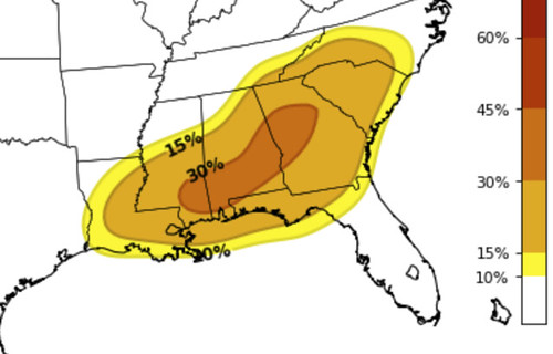
Day 4 (Monday) – A cutoff upper low will drift into northern Mexico Sunday before transitioning to an open wave and deamplifying as it ejects northeast through TX and the MS Valley. Partially modified
Gulf air will return through TX and scattered showers and possibly a few thunderstorms are expected to develop along the warm conveyor belt from east TX into the lower MS Valley, but destabilization is expected to remain insufficient for a severe threat.Day 6 (Tuesday) – Moisture return will be more robust from east TX into the lower MS Valley, downstream from a positive-tilt upper trough contributing to a corridor of modest instability. A broad fetch of strong southwest winds aloft will overspread a moistening warm sector. Thunderstorms are expected to redevelop along the warm conveyor belt from east TX to the lower MS Valley within a strongly sheared but modestly unstable environment with an attendant risk for a few strong to severe storms.
Days 7-8 (Wednesday-Thursday) – Mesoscale details for this period remain uncertain and will be dictated by areas of ongoing rain and thunderstorms, as well as timing of individual vorticity maxima rotating through the upper trough. However, the upper pattern with a slow moving synoptic upper trough maintaining a broad fetch of strong southwesterly flow across the moist warm sector, will contribute to some risk for strong to severe storms with episodes of convection developing along the warm conveyor belt.
Early Thoughts
The CIPS Analogs came back this morning with some robust numbers, but is also a day late with the system.
All types of severe weather, and all the other weather that comes with it, will be possible. Things like heavy rain, frequent lightning, hail, gusty wind, and the potential for a tornado or two.
There is some indication that we may be saved from the worst of the weather by a cluster of storms in the Gulf that may rob out area of some of the richer moisture and warmer temperatures. You may have heard me refer to this type of thing as “the Blob” before.
Outside of that, it is a bit too early for specifics. A lot of you probably want to know “will there be tornadoes” or “How bad will it be where I live?” but no one knows that yet.
The only thing we know is that the model data shows a scenario that the atmosphere will be capable of producing stronger or severe storms.
What is in those storms and where they go, is anyone’s guess at this point.


