UPDATE (Monday, 9am): The Storm Prediction Center has decreased the severe weather risk to a Marginal risk for sections – but not all – of Mississippi, Louisiana and Alabama.
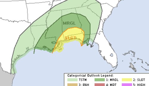
The SPC notes: “This should be favorable for a severe threat as a cluster or line of storms affects the central Gulf Coast region late Wednesday night. Wind damage and hail would be possible with the stronger thunderstorms. Will maintain a slight risk area from southern Mississippi eastward across southern Alabama and the Florida Panhandle where instability, shear and lift are forecast to be maximized late in the period.”
ORIGNAL: There is still the chance for severe weather across parts of the Gulf Coast Wednesday. The timeline is still from late Tuesday night through early Thursday morning.
The Gulf Coast has been “blobbed” a handful of times in the last few years. Generally this happens once (sometimes twice) per winter. There is a severe weather setup, but storms just off the coast – or along the coast – form and rob the area of the heat and moisture needed to produce severe weather.
What makes this happen certain times more than others? A lot of things. I won’t bore you with the details, but know that there are a bunch things that need to come together at the right places at the right times to get this to happen. That is what it isn’t a very frequent occurrence.
But there is hope for this go-around. I mentioned this the other day in the first post about the threat, noting that there was a chance that storms in the Gulf may help us out.
Well, here we are
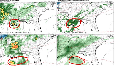
On the image above of the ECMWF, GFS, GDPS, and NAM, all four models (which use differing atmospheric physics to build a data set) have some sort of blob of storms along the coast or out in the the Gulf. The area of interest in circled in red on each map.
I know what you’re thinking: “Booyeah!”
But don’t get too excited yet. While this could limit the potential for severe weather, it wouldn’t kill it completely. And we are still about 72 hours out from the event. And we are just starting to get into the window where we – as meteorologists – start to get a much better idea about what will happen.
The Storm Prediction Center maintains a Slight Risk for severe weather for the Gulf Coast.
The area is relatively unchanged from yesterday’s outlook.
From the SPC:
…Wednesday/Day 4 and Thursday/Day 5…
An upper-level trough is forecast to move eastward across the High Plains on Wednesday as southwest mid-level flow remains over the central and eastern U.S. At the surface, a cold front is forecast to move southeastward into the Gulf Coast States. Ahead of the front, a moist airmass should be in place. Thunderstorm development is expected to occur during the day along and ahead of the front from the lower Mississippi Valley eastward into the central Gulf Coast States. Surface heating along with dewpoints in the mid to upper 60s F should contribute to sufficient destabilization for the development of strong thunderstorms from late morning into the afternoon. An 80 to 100 kt mid-level jet is forecast to move northeastward across the lower to mid Mississippi Valley. This feature will create strong deep-layer shear across much of the Southeast, which should be favorable for severe storms. The current thinking is that a squall line with a wind-damage and tornado threat will organize ahead of the front Wednesday afternoon. This line is forecast to remain intact Wednesday night into Thursday, moving eastward into Georgia, Florida and the Carolinas. A severe threat will be possible with this line of storms on Thursday as well.
Right now it still looks like all modes of severe weather – and the weather that comes with it – will be possible: heavy rain, frequent lightning, gusty wind, hail and the potential for a tornado.
The not-as-obvious concern
If you guessed “flooding!” then you’re right.
Model guidance shows a chance for storms to train of the same areas starting late Tuesday through Thursday afternoon. That means that even after the front passes through and the threat for severe weather subsides, the threat for flooding – depending on location – may not.
Where will it flood?
No one knows yet. A lot like severe weather, specifics about flooding work just like specifics about tornadoes. Meteorologists likely won’t know until – at the soonest – about 24 hours out. And even that isn’t a guarantee.
What is evident within the data is that 2″ to 5″ of rain will be possible across parts of Louisiana, Mississippi and Alabama between Tuesday and Thursday. If storms continue move over the same area, totals exceeding 5″ of rain may be possible, too.
What can you do now to prepare?
Keep tabs on the forecast. While we continue to look over all of the model data, the goal is to provide the most up-to-date forecast as possible. And as soon as we know something, we will pass it along.
In the meantime, do you have a severe weather prep kit? Safe place mapped out? Do you have a plan for what you would do if a warning – any warning – was issued for your area?
All good things to think about. It is important to have a plan (not because this is looking like a “seriously bad” or “mega awful” event) during severe weather so you can react quickly!


