Southern parts of Louisiana, Mississippi, Alabama face severe risk and flooding potential Tuesday, Wednesday and Thursday
Author: Nick Lilja
|| Published: 3/1/2020 at 10:54pm
That is a lot of words in the title, but there is also a lot happening in the weather during the Tuesday through Thursday timeframe for parts of the Gulf Coast.
As an area of low pressure swings through the region, it will open the door for showers and storms to develop. Some of these storms could be severe and others could drop some very – very! – heavy rain. The main threats right now from any storm look like heavy rain, frequent lightning, gusty wind (up to 65mph), hail (up to the size of quarters), and the potential to produce a tornado.
The other concern is for storms to “train” over the same places. That means just as soon as a storm leaves an area, another comes in right behind it. That would lead to some spots picking up a lot of rain. While a blanket possibility of 1″ to 4″ of rain still hold, if trianing occurs, some places could see more than 7″ of rain.
Tonight, I’m not going to get too sciency, though.
From the SPC
Here is a look at what the Storm Prediction Center is saying about the risk for severe weather.
Tuesday’s severe weather risk // Courtesy: spc.noaa.gov
An upper low will likely be centered over northwest Mexico early Tuesday morning. Strong mid-level flow will extend from the western periphery of the low around its base and eastward through the Southern Plains and Lower MS Valley. This low is forecast to gradually move eastward across northern Mexico and the southern High Plains during the period. At the same time, northern-stream shortwave trough is expected to move through the Upper MS Valley and Upper Great Lakes. More confluent upper pattern downstream of these two systems will result in a large area of enhanced mid-level flow across the eastern CONUS.
Surface pattern early Tuesday is expected to feature a cold front extending from southern OH southwestward to the Edwards Plateau in TX. Eastern portion of this front will likely remain progressive, moving through portions of the TN Valley and Southeast. However, southerly progress along the western portion of the front over TX should slow throughout the morning before then moving back northward as cyclogenesis occurs across eastern Mexico. The resulting surface low is then expected to move eastward along the front across the TX Coastal Plain late Tuesday night/early Wednesday morning.
Surface convergence along the front as well as lift attendant to the surface low and lift sourced by the increasing warm-air advection will result in thunderstorm development along and north of the front from the Edwards Plateau through the Lower MS Valley. Despite mid 60s dewpoints along and ahead the front, instability will be tempered somewhat by the warm temperatures aloft. Even so, the strongly sheared environment should still support updrafts strong enough to produce hail and/or damaging wind gusts. A messy, clustered storm mode is anticipated for much of this activity, but there is some potential for more linear development near and south of the surface low. Higher severe probability could result from a more linear, surface-based storm structure but forecast uncertainty remains too high for much confidence regarding that scenario.
Wednesday’s severe weahter risk // Courtesy: spc.noaa.gov
Southern-stream upper low will likely be centered over far west TX early D4/Wednesday morning, with an associated surface low a bit farther east over the middle TX coast. This upper low is forecast to gradually move northeastward through the day D4/Wednesday, likely reaching the lower MS Valley by early D5/Thursday. Strong forcing for ascent will accompany this system and numerous thunderstorms are expected from across TX, the lower MS Valley, and the Southeast states. Much of this activity will likely be along and north of the front, but some potential for more warm-sector storms exists across southern LA and adjacent southern MS. Shear profiles in this region
support supercells and enough model consensus exists to introduce a 15% probability over the area.
Choose Your Own Adventure
This is one of those right-on-the-fence situations. Because all of this is depending on where the cold front sets up, if it moves back north as a warm front, and where the surface low moves.
The surface low is really the linchpin here. The track of the low will really dictate all of this and there are a few options…
If this happens, the cold front that is slated to move into the area wouldn’t likely make it too far south. That would allow for more warm, unstable air, to pool across the region. That mean the threat for severe weather increases for places south of I-20 in Louisiana, Mississippi and Alabama. It would mean an increase in the potential for all modes of severe weather, too. That includes tornadoes.
Two analogs from the upcoming event from the CIPS Analogs // Courtesy: Saint Louis University
That would be what these two analogs would be showing from CIPS. These are two events where the low ended up further inland and there was enough spin in the atmosphere as well as enough low-level instability, to get thunderstorms to turn severe.
This would mean the timeline for storms would be from Tuesday PM through Thursday AM across the region. A long time to deal with storms.
2. The low moves inland, but not too far
If this happens, and say it moves inland to about Baton Rouge and slides east toward Dothan, that would mean the cold front would make it south to about the halfway point between I-20 and I-10 before, likely stalling out. This would open the door for a brief window of opportunity for severe weather Ahead of the low as it passes, but only for those places closer to the coast. From Around Baton Rouge, Hattiesburg, Evergreen, and Dothan and points south.
The threats then would like be more about heavy rain and wind. While a brief tornado can’t be ruled out, strong tornadoes would be a little more difficult for the atmosphere to create.
The problem would then become flooding. With the front stalled out along the coast, it is more likely that storms would train along the front as elevated storms. This may allow a cold pool to develop on the backside of some of these storms, and that may help to amplify the proficiency of these storms to drop a lot of water. Because as the warm, moist Gulf of Mexico air rides up over that cold pool, it would cool and condense and precipitate out that much more water.
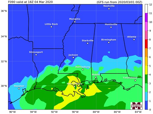
GFS Computer Weather Model showing Precipitable Water values near record levels for the region on Wednesday afternoon // Courtesy: Pivotal Weather
And there will be ample moisture.
The GFS, shown above, is showing near-record levels of atmospheric moisture to pull from. So any thunderstorm that does develop is already going to be dumping copious amounts of rainfall. If that cold pool can get rooted, a lot of this rich moisture may ride up over it if the mid-level flow is parallel the axis of that line.
The low stays out to sea
While this is an unlikely scenario, it isn’t impossible. If this happens, the severe weather threat will be almost completely mitigated. You may have to keep tabs on spinny showers moving onto land from the water along the coast, but that would be about it.
This would still lead to a fair amount of rain for the area, but maybe not quite as much since the cold pool in this case would be further south and the heaviest of the rain would fall in the Gulf.
That said, there would still be a swatch of 1″ to 4″ of rain possible. So it isn’t like we get out of this free from any kind of disruptive weather.
The Karrie Meter
Based on the 12z data from the GFS, the overnight hours Tuesday and into Wednesday may feature a chance for severe weather from I-20 south.
Karrie Meter for Tuesday night and into Wednesday morning // Map Courtesy: Dr. Kimn Wood, Mississippi STate University
That same data shows the best chance for severe weather closer to the coastline during the day on Wednesday.
Karrie Meter for Wednesday afternoon // Map Courtesy: Dr. Kimn Wood, Mississippi STate University
This lines up with what the SPC is showing, too. So it is good to see that the Karrie Meter and the SPC are on the same page.
Timeline
Monday: A few showers and storms pass through, but these should be non-severe
Tuesday: Showers and storms develop in the afternoon and evening, these may be severe depending on the track of the Low. Rainfall may be very heavy at times, too. localized flooding may be possible
Wednesday: Showers and storms may be on-going in the morning and may continue through the day. The severe risk will be dictated by the track of the Low. Rainfall may be very heavy at times, too. localized flooding may be possible
Thursday: Rain begins to move out of the area in the morning and should be clear of the region by evening. But any lingering showers and storms will still e pretty proficient rainfall producers.
The Bottom Line
It is going to rain in the region between Monday night and Thursday morning. There is the chance for a few severe storms – at a minimum – and some flooding is possible, too.
Frankly, we don’t know specifics yet. Because we are still dealing with three options, we can’t really nail it down completely yet. We are just starting to get within the 72 hour window, though, which should really start to open doors for us to get a better handle on how this next system will evolve.
Author of the article:
Nick Lilja
Nick is former television meteorologist with stints in Amarillo and Hattiesburg. During his time in Hattiesburg, he was also an adjunct professor at the University of Southern Mississippi. He is a graduate of both Oregon State and Syracuse University that now calls Houston home. Now that he is retired from TV, he runs this site and its app in his spare time.