I made mention of this on twitter the other day.
I’m starting to think this next system is going to be more of a rain event for south Mississippi….
— Nick Lilja (@NickLilja) March 1, 2020
And the trend I was picking up on seems to continue to lean in that direction. This is starting to look like more of an event of heavy rain, some wind, some hail and flooding.
Perhaps widespread flooding, too.
The Analogs
Even the analogs are starting to pull back on the threat for severe weather. You can see within the CIPS Analogs taht the track of the low was really dictating who saw severe weather and how much. Originally, it had the low moving NE through Texas and Oklahoma, then it moved the low to slide through east Texas and closer to Arkansas and through Tennessee, then the data showed it would move through Louisiana, Mississippi and into eastern Tennessee.

Now the data shows it moving ashore in Louisiana, and hugging the coastline through Mississippi and Alabama. The result? Lower chances for severe weather, and higher chances for heavy rainfall.
This is something I highlighted late last night in my post about “choosing your own adventure” with the weather.
The analogs are now suggesting a decent shot for some significant rainfall across parts of the region.
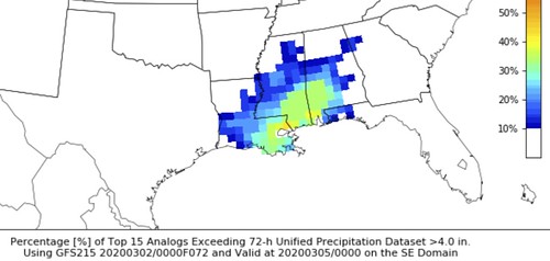
The short-range CIPS shows portions of Mississippi and Alabama have received more then four-inches of rain from past storms that did this about 40-percent of the time.
The Weather Prediction Center
The Weather Prediction Center continues to highlight the region for potential flash flooding Tuesday and Wednesday.

You can see that the highest totals for the southern United States will be in some of the same areas the WPC is highlighting for flash flooding.

Here is a quick read of the discussion from the WPC for Wednesday:
As the closed mid-level low continues to track eastward, strong divergence aloft will strengthen downstream. In response, deep layer southerly flow will increase helping to advect moist unstable air north against a frontal boundary draped across the Gulf Coast States. This combined with mid-level impulses will promote widespread shower and thunderstorms along and just north of the front as the surface low tracks east along the boundary.
Precipitable water values should climb above 1.75 inches (which is 2.5 standard deviations above the mean) aided by 30+ knot southerly flow off the Gulf of Mexico. This combined with MUCAPE values well well above 10000 J/kg along the coast, should result in heavy rainfall across southern portions of LA/MS/AL/GA and the panhandle of FL. There has been quite a bit of uncertainty with respect to the frontal placement in the Deep South and the instability axis, but the trend has continues to be south which aligns with the expected mesoscale features. Areal average precipitation will be a widespread 0.5-1+ from central TX east to SC.
However, as mentioned above, the best overlapping ingredient will across the Deep South/Southeast produce a 1.5-2+ inches along and just north of the frontal zone.
These QPF values could increase at subsequent updates solely due to the training potential of convection as the surface low tracks east. Given much of this area has received over 200% of normal precipitation over the past couple week with the Day 2 QPF in mind, felt a broad Slight Risk for flash flooding was warranted. If QPF amounts trend upward within the Slight Risk region, a Moderate Risk may be needed at future updates.
As an aside, did consider a Slight Risk across portions of east TX associated with the apparent low, but with too much model spread kept it a Marginal Risk for now. However, could see the potential to hoist a Slight is QPF increases.
From the Storm Prediction Center
Usually I put the breakdown from the SPC first, but since I’m starting to become more concerned about flooding, I opted to drop the “importance” of the severe threat and put it behind the WPC.
Here is a look at the severe risk for Tuesday:

Here is a look at the severe risk for Wednesday:
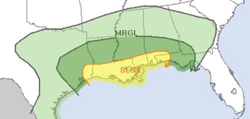
Notice the bulk of the region is under Marginal Risk for severe weather from the SPC. The Slight Risk hugs the coast on Wednesday. And the main threats both days for the area will be rain, wind and hail. The tornado threat is low, but certainly not zero.
Timeline
Monday: A few showers and storms pass through, but these should be non-severe.
Tuesday: Showers and storms develop in the afternoon and evening, these may be severe depending on the track of the Low. Rainfall may be very heavy at times, too. localized flooding may be possible
Wednesday: Showers and storms may be on-going in the morning and may continue through the day. The severe risk will be dictated by the track of the Low, but for now looks like it will be closer to the coast. Rainfall may be very heavy at times, too. localized flooding looks likely for some, but figuring out exactly where at this point is not possible.
Thursday: Rain begins to move out of the area in the morning and should be clear of the region by evening. But any lingering showers and storms will still e pretty proficient rainfall producers.
The Bottom Line
Reasonably unchanged. It is going to rain in the region between Monday night and Thursday morning. There is the chance for a few severe storms but flooding is looking more likely than severe weather, at this point.
Rainfall totals of 1″ to 6″ – a very wide spread in numbers – will be possible. It just depends on where storms line up. And we won’t get a better idea about that until later tonight (Monday night) and into tomorrow (Tuesday). But since this is a very ‘delicate balance’ type situation, it will need to be monitored closely.


