Author: Nick Lilja
|| Published: 4/8/2020 at 10:14am
At least we will all be at home, already. In fact, now may be a good time to review your severe weather safety plan. The “Where would you go? What would you do?” if a tornado warning was issued for your area plan.
By coincidence, the National Weather Association is promoting their #SafePlaceSelfie campaign today, Wednesday, April 8th.
— National Weather Association (@nwas) April 8, 2020
Since you will already be thinking about your plan and where you would take cover, you may as well snap a selfie and tweet it to them! I also think they are posting things on instagram and facebook, too. So even if you don’t twitter, you can still have fun!
Back to the weather, though…
The Setup
As the next system breaks out into the plains and across parts of the southeast, it may go “negative-tilt” and line up to bring the southeast a chance for storms. With the anomalously warm Gulf of Mexico pumping in very warm and humid air ahead of a cold front with anomalously cold air back in behind it, it is setting the stage for the potential for some significant severe weather.
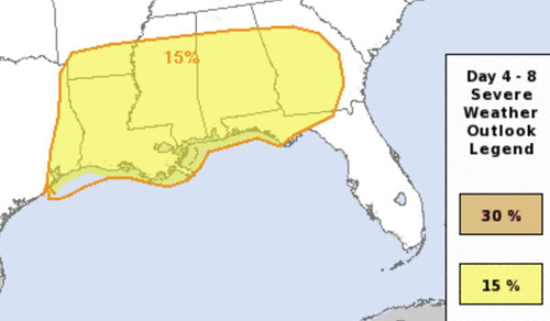
From the Storm Prediction Center
The SPC has set a broad Slight Risk for severe weather across the southeast on Sunday. This is a “2” on the 1-to-5 scale where “5” is the highest risk for severe weather. They did note, though, that if model trends continue to lean toward the current suggested setup that the number will need to be increased.
…D5/Sunday: Arklatex/Lower MS Valley into the Southeast…
Timing differences continue among the extended-range guidance into D5/Sunday, with the GFS notably faster, while the 08/00Z ECMWF has trended slower compared to other guidance as well as its own previous cycles. Regardless of timing, most guidance depicts the ejecting trough as taking on a neutral to negative tilt, with a deepening surface low moving into portions of the MS/TN Valleys. While the northward extent of substantial destabilization remains uncertain due to the potential for widespread convection, sufficient instability and increasing low-level and deep-layer shear will support a severe thunderstorm threat across much of the Southeast throughout the day into Sunday night. If very rich low-level moisture (low 70s dewpoints) over the Gulf can spread inland in advance of this dynamic system, as depicted by recent ECMWF/UKMET runs, then a substantial severe thunderstorm event could evolve, with all hazards possible. Higher probabilities will be required if guidance continues to trend in that direction.
Courtesy: spc.noaa.gov
The severe threat could spread into portions of the Carolinas and mid Atlantic on Sunday night, though too much uncertainty remains
regarding the northward extent of surface-based destabilization to include probabilities for those areas at this time.
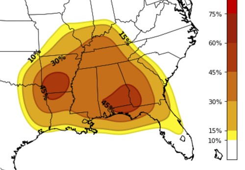
From the CIPS Analogs
The shorter-range deterministic analogs are based on the GFS which, while usually a reliable model, may not be handling this next system as well as the GEFS model, the ensemble version of the same model. BEcause of that, I’m not going to show the GFS “deterministic” model data, instead I’m going to show the “ensemble” model data from the GEFS.
Courtesy: Saint Louis University
The map above is the CIPS Analogs looking at the model data, comparing it to past events and then making a prediction about the potential to see severe weather in a particular area.
You can see two “bulls eye” areas, one in southern Arkansas and the other in southern Alabama. Both showing a 45-percent chance, given the current data, that a severe storm develops in that area.
Please know, the specific areas with the highest percentages are likely going to change in the coming days. But I wanted to show this to highlight that model data is showing a pretty good shot that severe weather happens in the southeast on Easter Sunday.
Where specifically? Who has the best chance for the worst weather? That is still an unknowable thing at this point.
Because you guys are in my “region” of coverage, I wanted to take some time to specifically point out that some of the model data is showing a potentially volatile setup for you. This is where the track of the entire system becomes very important, though.
That is the “deterministic” run of the ECMWF model. It shows the area of low pressure off the coast of California today move through the southwest, into Texas and then through parts of Arkansas and to the NE into Kentucky.
That is the “worse case scenario” for storm track for the region. This would leave parts of Louisiana, Mississippi and Alabama is the prime position for seeing severe weather.
But if the whole system move a bit more north or a bit more south (the more south, the better), that would lower the threat for severe weather for the region. Not to zero, but reduce the risk of significant severe weather.
The Bottom Line
For now, please just keep tabs on the weather forecast in the coming days. It looks like Easter Sunday will feature the potential for severe weather for the Southeast. All modes of severe weather look possible at this point.
We don’t have specifics nailed down yet, and we won’t start to get a better idea about specifics for at least another 24 hours. Like always, the 72 hour mark is really when we can start to make estimates and forecasts about certain threats, specific areas of concerns, etc.
Author of the article:
Nick Lilja
Nick is former television meteorologist with stints in Amarillo and Hattiesburg. During his time in Hattiesburg, he was also an adjunct professor at the University of Southern Mississippi. He is a graduate of both Oregon State and Syracuse University that now calls Houston home. Now that he is retired from TV, he maintains this blog in his spare time.