As the next system continues to drift toward the region, there is increasing confidence that when it arrives it will bring significant severe weather with it.

The Storm Prediction Center opted to keep – roughly – the same Moderate risk area for the southeast, but expanded the Enhanced Risk area and Slight Risk area.
From the SPC
…East TX northeastward through much of the Southeast and TN Valley…
One or more clusters of deep convection will likely be ongoing at 12Z Sunday morning somewhere over east TX and potentially into portions of the lower MS Valley. The intensity and areal extent of any such clusters remain uncertain, but ample shear and instability will favor a threat of hail and damaging wind with any organized convection at the start of the period. Some tornado threat will also be present Sunday morning with any semi-discrete storms that begin to interact with the richer low-level moisture in the vicinity of the warm front. As this convection spreads northeastward, intensification is possible into portions of the ArkLAMiss region, with an increasing tornado threat in late morning/early afternoon with any surface-based storms, given rapidly increasing low-level moisture and shear. North of the warm front, evolution into a QLCS will be possible, with a corresponding risk of damaging wind into portions of the TN Valley.
Meanwhile, further south, moderate to locally strong instability is forecast to develop along/south of the warm frontal position, which will be modulated by the impact of outflow from any early convection described above. Midlevel flow will increase to 70-100 kt as a south-southwesterly low-level jet intensifies into the 40-60 kt range. These wind profiles combined with ample instability (MLCAPE of 1500-3000 J/kg) will support the potential for intense supercells. Any surface-based initiation along and east of a pseudo-dryline moving into western LA by late afternoon could evolve into one or more long-tracked supercells capable of producing strong tornadoes, large hail, and damaging wind gusts. The extent of development within the warm sector remains somewhat uncertain, given the presence of a capping inversion and generally subtle foci for initiation.
While the conditional risk of all severe hazards will be quite high if supercells develop, uncertainty remains regarding how convection will evolve from the morning into the afternoon. Any remnant outflow related to early convection will determine the northern extent of the higher-end tornado potential, and some guidance suggests the potential for elevated convection within a midlevel moist plume across the warm sector during the afternoon, which could either dampen the severe potential, or evolve into surface-based convection with a substantial severe threat. Given these factors, there is too much uncertainty to upgrade the ongoing outlook at this time.
Evolution into more of QLCS is suggested by most guidance by Sunday evening, which would pose an increasing threat of widespread damaging winds and a few tornadoes across much of AL into western/central GA through the overnight hours. Higher wind probabilities may be needed in subsequent outlooks if confidence in this scenario grows.
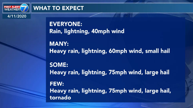
Breaking down the risks
1:00 AM update concerning Easter Sunday severe setup… minimal changes. https://t.co/V2iBBhx594 #mswx #severeweatherms #Easter #EasterSunday #EasterWeekend #weatheraware pic.twitter.com/RSWSkxDLNH
— Severe Weather MS (@SevereWeatherMS) April 11, 2020
The SPC introduced a 15-percent “hatched” tornado risk for portions of Louisiana, Mississippi, Arkansas, and Alabama.

That means, in a sense, that those areas are 15-times-more-likely to see a tornado on Sunday than any other regular thunderstorming day. It is also indicating that significant tornadoes will be possible, too – a tornado that produces EF2 or greater damage.
The SPC also added a 30-percent “hatched” area for large hail.

In the same way, this means those areas are 30-times-more-likely to see large hail on Sunday than any other regular day. And some of that hail may be significant – two-inch in diameter or larger.
All of that said, it is important to remember that under the Risk Area, it is not indicating that everyone in that area will experience those conditions. It is indicating that people in that area may experience those conditions.
Analogs
The CIPS Canalogs from Saint Louis University continue to add credence to the SPC’s risk areas.

This version of the CIPS is powered by the GEFS and is not only looking back in time to see how likely an event occurred, but then makes a projection for what is likely to occur based off of past events.
Based on this run from the morning of April 10th, there is a better than 30-percent chance for severe weather over a large portion of the Mid-South and Southeast.
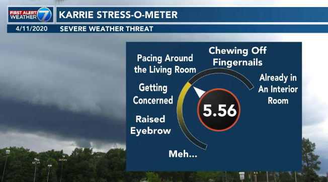
The Karrie Meter
For South Mississippi, the Karrie Meter has settled to between about 5.4 and 5.9 during the last 48 hours. It originally started at a 6.5, but quickly eased back to the mid to high 5s and hasn’t budged much since.
Here is a look at the Karrie Meter Map, using the GFS model, thanks to Dr. Kim Wood at Mississippi State. This animated map will render through – every three hours – through the event.
I will say this, the one thing I like about the GFS map here is that it can’t pick out where the storms are. All it shows is where the background environment is most favorable for the development of severe weather.
That means, we can use it to highlight areas of concern without worrying that the model is “seeing” the specific updrafts within storms to skew the data one way or the other.
Updraft Helicity Streaks
Speaking of updrafts, these are still a bit too far out to be meaningful. We are likely going to have to wait until tomorrow morning around 10am before we get a look at those. For now, most of them were showing a higher threat north of I-20. But again, I think we are going to have to wait until about 10am Saturday morning before we get good data in on those.
So, nothing changed from the SPC but other things changed… So, what does this change mean?
Honestly, I have to go with The Rock on this one:
The forecast for what you need to do to prepare is….
— Have a NOAA Weather Radio programmed up with fresh batteries
— Have a good weather app from a local TV station (preferably one with meteorologists on staff) that can also alert you when warnings are issued and give you a look at the radar
— Have a Severe Weather Plan (know what you would do if a warning was issued for your area)
— Have supplies you would need should the power go out or should there be damage to your home from a storm
— If you plan to go to a shelter, make sure you know how to get there, when they are open, and how you will protect yourself from COVID-19 while there
Want more information about severe weather and tornado safety? Check this out!
We will continue to pick up more data and be able to fine-tune the forecast tomorrow. But for now, get prepared by making sure you have all of your necessary items and plans in place.


I love knowing the science behind these systems and nobody explains it better. It keeps my blood pressure at reasonable levels because there is no hype, just data. I always prepare accordingly. THANK YOU NICK. Your forecasts are far more appreciated than you know.