As the model data continues to trickle in, the potential for some significant severe weather across parts of the Mid-South and Southeast is looking more likely. A lot of people are saying a “severe weather outbreak” is likely. While I’m not one to call an outbreak before an outbreak outbreaks… I can understand why people are choosing to use that language.

As posted on facebook by a National Weather Service friend of mine, yesterday the Day 3 Moderate Risk events are reasonably rare. And about half the time end up resulting in a High Risk by the day of the event.
This is the 18th Day 3 Moderate Risk Outlook issued by SPC. Here’s how the other 17 prior issuances evolved:
-Day 2: 16 moderate, 1 high risk
-Day 1: 7 moderate, 10 high risk (58%)Regardless of risk on the day of the event, there is a reasonable degree of confidence that a severe weather outbreak could occur on Easter Sunday. Folks that I know in the south should prepare and follow their local NWS office for the latest forecasts.
But, if you have some level of anxiety with this whole situation, allow me help to try to ease your nerves and help you prepare.
The most important thing to remember is that while an “outbreak” may sound like everyone is going to see severe weather, that isn’t necessarily the case.
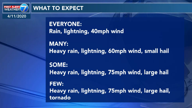
The above graphic hopefully adds some context to the forecast. While nearly everyone will see rain and wind – and that can still cause damage – from the storms that develop, only a few people (relative to the entire collection of Risk Areas) will see a tornado.
So, how do you prepare?
— Have a NOAA Weather Radio programmed up with fresh batteries
— Have a good weather app from a local TV station (preferably one with meteorologists on staff) that can also alert you when warnings are issued and give you a look at the radar
— Have a Severe Weather Plan (know what you would do if a warning was issued for your area)
— Have supplies you would need should the power go out or should there be damage to your home from a storm
— LEave a TV on somewhere in the house tuned to a local news station so if a new warning is issued for your region, you can get the heads up and see if it will be near you eventually
— If you plan to go to a shelter, make sure you know how to get there, when they are open, and how you will protect yourself from COVID-19 while there
Want more information about severe weather and tornado safety? Check this out!
And now you’re ready to go.
The data
I have some good news to pass along: Things are looking like the forecast isn’t changing much for the Gulf Coast (within about 70 miles of the water) for Louisiana, Mississippi, Alabama and the Florida panhandle.
The bad news is that the forecast wasn’t exactly sunshine, rainbows and light breezes.
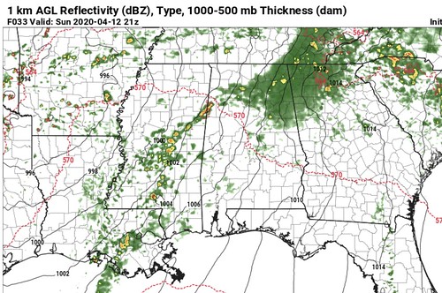
Here is a look at the projected radar from the NAM-3km model for Sunday afternoon around 3pm. It shows a messy setup with clusters of showers and storms across parts of Mississippi, Louisiana and Alabama. Notice that there are not just a handful of supercells, and instead, there are clutery-type storms all over the place. This has to do with what is happening – top to bottom – in the atmosphere.
While some of the severe weather parameters are “off the charts” as some have put it, those parameters may not be “off the charts” in a way that is meaningful to the production of severe weather.
Because of that, storms may have a more difficult time becoming supercellular (organized). The lack of the right things in the right places at the right times means that storms will be a bit messy and clutery. And then struggle to develop and organize due to the lack of those needed organizational parameters and their constant interaction with each other.
That will not negate the threat for any severe weather completely, but may limit the spread of significant severe weather to only a handful of storms in the Gulf Coast region. But that will only happen where storms become discrete (on their own) and organized (supercellular).
Where is that more likely to occur, you ask? North of the Gulf Coast.
Updraft Helicity Streaks
South Of I-20 in Louisiana, Mississippi and across parts of Lower Alabama and the Florida panhandle are still looking at the chance for significant severe weather, it just may not be as widespread as other places.
That is shown pretty well by the Updraft Helicity Streaks.

Recall that these “UH Streaks” are a good approximation for figuring out which areas may have the strongest storms. These are not ‘set in stone’ and often change specific placement on the map. What we are looking for here is the magnitude of the UH Streaks (colorfulness) to get an idea about which larger areas are more likely to have the strongest rotating updrafts.
I never look at just one of these maps and run away with an answer. You really have to look at the two or three outputs leading up to an event. Here is a look at that smae projection from 12 hours ago.

Notice it put more UH Streaks into Alabama 12 hours ago. And in 12 hours it may move again. And while it is important to track the movements, it is equally as important to track where it is not moving. And that is in northern Louisiana and north-central Mississippi.
Again, I want to reiterate, that just because it shows that the strongest rotating updrafts will be in those places that those are the only places that will see the strongest storms. It just suggests that the likelihood that those areas see a stronger storm is higher.
The Analogs
Get ready to hit the “dislike” button.
While the UH Streaks show one thing, the Analogs show another. The CIPS Analogs from Saint Louis University show that the greatest chance for seeing a tornado is actually closer to the coast.
In particular in SW Mississippi.
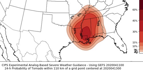
The CIPS is different than the HRW model above. The CIPS is looking at historical data to make a projection. Sifting through data of past events to find similarities with this upcoming event. You can think of it like a charades game-show on TV where the contestants can say similar things but not the thing and the guesser has to come up with an answer.
CIPS is looking information from past events like 500mb wind, 850mb dew point, surface pressure, etc., and also what happened in those past events (big tornadoes, only hail, just some wind). Then it compares that information to the current model trends and makes a “guess” based on the available data.
And it can do very well. And it can also miss. Much like other parts of weather forecast, there is no Silver Bullet or One model that has all the answers. It is a combination of many different things to come up with a forecast.
From the SPC
…SUMMARY…
An outbreak of severe thunderstorms appears likely Sunday into Sunday night, with the greatest threat expected from Louisiana through much of the Southeast and Tennessee Valley. Strong tornadoes, potentially widespread damaging winds, and large hail are all possible.
…Synopsis…
The ejecting shortwave trough initially over the southern High Plains on Sunday morning is forecast to move quickly eastward to the lower MS Valley by early evening, and then accelerate northeastward toward the Ohio Valley late Sunday night into Monday morning, as it becomes absorbed within an amplifying longwave trough that will encompass nearly all the CONUS by 12Z Monday. In conjunction with the ejecting trough, a broad surface low centered over the central/southern Plains on Sunday morning will move eastward to the mid-MS Valley by 00Z Monday, and then move northeastward and rapidly intensify into an intense cyclone over the lower Great Lakes by 12Z Monday. A warm front will surge northward ahead of the low across the lower MS Valley and Southeast, while a strong cold front will move southward through much of the Plains in the wake of the departing cyclone.
…East TX northeastward through much of the Southeast and TN Valley…
One or more clusters of deep convection will likely be ongoing at 12Z Sunday morning somewhere over east TX and potentially into portions of the lower MS Valley. The intensity and areal extent of any such clusters remain uncertain, but ample shear and instability will favor a threat of hail and damaging wind with any organized convection at the start of the period. Some tornado threat will also be present Sunday morning with any semi-discrete storms that begin to interact with the richer low-level moisture in the vicinity of the warm front. As this convection spreads northeastward, intensification is possible into portions of the ArkLAMiss region, with an increasing tornado threat in late morning/early afternoon with any surface-based storms, given rapidly increasing low-level moisture and shear. North of the warm front, evolution into a QLCS will be possible, with a risk of damaging wind into portions of the TN Valley.

Farther south, moderate to locally strong instability is forecast to develop along/south of the warm frontal position, which will be modulated by the impact of outflow from any early convection described above. Midlevel flow will increase to 70-100 kt as a south-southwesterly low-level jet intensifies into the 40-60 kt range. These wind profiles combined with ample instability (MLCAPE of 1500-3000 J/kg) will support the potential for intense supercells. Any surface-based initiation along and east of a pseudo-dryline moving into western LA by late afternoon could evolve into one or more long-tracked supercells capable of producing strong tornadoes, large hail, and damaging wind gusts. The extent of development within the warm sector remains somewhat uncertain, given the presence of a capping inversion and generally subtle foci for initiation.
While the conditional risk of all severe hazards will be quite high if supercells develop, uncertainty remains regarding how convection will evolve from the morning into the afternoon. Any remnant outflow related to early convection will determine the northern extent of the higher-end tornado potential, and some guidance suggests the potential for elevated convection within a midlevel moist plume across the warm sector during the afternoon, which could either dampen the severe potential, or evolve into surface-based convection with a substantial severe threat. Given these factors, there is too much uncertainty to upgrade the ongoing outlook at this time.
Evolution into more of QLCS is suggested by most guidance by Sunday evening, which would pose an increasing threat of widespread damaging winds and a few tornadoes across much of AL into western/central GA through the overnight hours. Higher wind probabilities may be needed in subsequent outlooks if confidence in this scenario grows.
The Bottom Line
Severe Weather will be possible across parts of the Gulf Coast on Easter. This comes with the potential for some significant severe weather. Significant severe weather is defined by tornadoes stronger than EF-2, wind in excess of 75mph, and hail bigger than two-inches in diameter.
Prepare now. Make plans. Have supplies ready. Know what you would do if a warning was issued for your area.
Threats
Heavy Rain
Lightning
Up to 75mph wind
Up to golf ball-sized hail
A tornado or two (stronger than EF-2 possible)
Timeline
Early Sunday morning through Early Monday morning. This is a 24-hour event for the whole region. For a more specific timeline for your particular area make sure to check with your favorite local meteorologist or National Weather Service.
We will continue to monitor model trends and track the weather and offer updates as necessary and when possible.


I did check with my local favorite Meteorologist. Thank you Nick. I appreciate the science and the no bull approach.