
It may feel like Groundhog Day in a sense. Severe weather is again looking like a possibility as we head through Sunday afternoon and evening across the Pine Belt. But there are some differences between this time and last weekend’s record-setting severe weather.
The data that is the most sticking-out-like-a-sore-thumb to meteorologists is that this weekend’s the overall setup isn’t as potent as last weekend’s.
The problem is, this weekend’s setup is still a potent setup for severe weather. Just not as potent. This weekend will still have the potential to produce heavy rain, lightning, wind gusts up to 65mph, hail up to the size of half dollars and tornadoes.
From the Storm Prediction Center
A progressive shortwave trough will move from the southern Plains into the lower MS Valley during the day, and will continue to the GA/SC/NC coast by Monday morning. The entire southeastern region will be under the influence of strong westerly winds aloft which will strengthen as the upper trough approaches. Southwesterly 850 mb winds will increase in response to the wave, reaching 50+ kt by 00Z from MS eastward to the coast.
At the surface, low pressure will develop near the ArkLaTex by late afternoon as a warm front lifts north across the southeastern states, oriented roughly from southern AR into northern MS, AL, and GA at 18Z. Meanwhile, a cold front/dryline will develop over east TX. Across the warm sector, rich moisture with 65-70 F dewpoints will result in moderate instability. The low, likely associated with widespread convection, will translate eastward along the synoptic front overnight, reaching NC by 12Z Monday.

…Southeastern states…
Substantial instability will already be in place Sunday morning from TX into the lower MS Valley, with rapid destabilization expected behind the warm front farther east into GA. Midlevel lapse rates aloft will be modestly steep, averaging 6.5 to 7.0 C/km. Early day storms related to warm advection will be present over AL and GA, and they will likely be elevated with perhaps a hail threat initially. As the air mass warms, a wind or tornado threat could develop in the vicinity of this activity as it continues east.
To the west, storms are likely to be severe by 18Z near the Sabine Valley/ArkLaTex. Here, long hodographs but modest low-level SRH may result in cells capable of very large hail, and perhaps an eventual MCS with damaging-wind threat. A severe wind corridor may thus develop during the day across northern MS, AL, and GA.
There is also a threat of daytime supercells, possibly tornadic, as the small capping inversion is eroded by early afternoon. During the evening and overnight, low-level shear will increase further, and models suggest southern AL into GA may be a favored area for tornadoes. Bows or isolated supercells are possible into SC early Monday morning as the relatively cooler air mass is destroyed by the warm front.
The Karrie Meter
In this case, the Karrie Meter may be indirectly highlighting where the real threat will manifest.
In this case, since an MCS is going to be the most likely mode of storm activity, the backside / northern edge of the strongest gradient in Karrie Meter numbers is a good starting point to try to estimate the placement of the MCS.
It looks like, for south Mississippi, that the strongest gradient is between Jackson and Hattiesburg. So, let’s see if data supports that…
Data and forecast
No, not that data. Model Data.
Now that we are within the 72 hour window, the model data becomes much more accurate. And it can hone in on timelines and specifics.
The GFS computer weather model is still showing a little impulse cruising across the area (blue line across LA/MS on the image below) before the trough passes through.

That will happen in an area where rich Gulf of Mexico air is being pulled north lower in the atmosphere. Shown below, the 850mb (about 4,000ft) wind barbs and dew point values show air being pulled around the base of the trough from the west, as well as air being pulled up from the Gulf of Mexico.

That should lead to the development of a cluster of storms to develop ahead of the main trough and front.
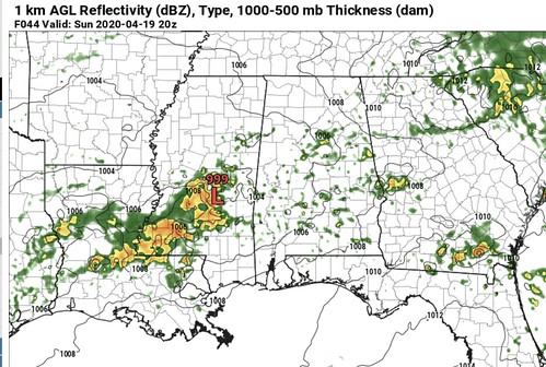
It actually looks like the HRW-ARW has a pretty decent estimation of radar for Sunday afternoon. While the exact placement may be a bit too far south, I think the overall presentation about what the area is looking at should hold.
The above image shows a cluster of storms or MCS moving across Louisiana and southern Mississippi and into Alabama during the afternoon on Sunday.
Depending on how it orients itself relative to the main flow through the atmosphere, there could be bowing line segments and embedded supercells. Ahead of and to the south of the MCS, the atmosphere will also be able to sustain discrete supercells. The question is whether or not any develop.
Taking a quick click on the Pivotal Weather NAM-3km computer weather model map shows a pretty robust sounding.

That said, this is just one click. If you look at some of the other sounding data across the region during this time period, things don’t appear as robust.
But, Nick! What’s the TOR:CON? What’s the SigTor?
I don’t know the TOR:CON, because that is a proprietary number the Weather Channel uses. They do not release the algorithm that does into it, so I cannot estimate a number. Unlike my Karrie Meter, the Weather Channel does not want their TOR:CON to be apart of the scientific community. They also use it as a marketing tool. And that is totally fine! I don’t mind that at all. No one does. But that is why I will never know the TOR:CON number when asked. Because I don’t have access to the formula.
The SigTor values, on the other hand, I can access. Those show reasonably high values of between “1” and “4” across the area. But those numbers aren’t as meaningful without understanding where boundaries and fronts will be. Because the gradient is usually more important than the number itself. A bullseye of a “10” somewhere looks scary, but it can actually be more active near an area where on one side it is a “0” and the other side is a “2”.
The Analogs
Historically speaking, this type of setup is one that promotes the development of severe weather. The CIPS Analogs out of Saint Louis University show that there is an equal chance for severe weather this weekend as last weekend.

But before you get too concerned about a repeat performance, the tornado threat is quite a bit lower this Sunday, according to the CIPS Analogs.

The tornado threat is lower in the-chance-a-tornado-occurs and, although not shown here, the-strength-of-potential-tornado. Last week the potential was “as high as EF-4” while this Sunday it is “as high as EF-2.”
Here is the really – REALLY! – important thing, though. An EF-2 is still a “strong” tornado. Most of the damage along the path of the tornado from this past weekend was EF-0, EF-1, EF-2 damage. Yes, the worst of the damage was EF-3 and EF-4 damage. But most people who experienced the tornado, experienced EF-2 and weaker wind speeds. And it still did a fair amount of damage in those spots.
The Timeline & Threats
Rain and storms will begin as early as 10am. It looks like the threat for severe weather will begin around 12pm and last through about 10pm at night.
The main threats….
Heavy rain
Flash flooding
Frequent lightning
Wind gusts to 65mph (depending on how things line up, up to 75mph could be possible)
Hail up to the size of half dollars
A tornado or two (up to EF-2 in strength is possible, but not likely)
The Bottom Line
Storms will be possible Sunday afternoon and evening. Most of these storms are going to feature very heavy rain, a lot of lightning, some very gusty wind, and some hail. There is chance that the area sees another tornado, maybe a few. And those could be as strong as EF-2. But it is a smaller chance than last weekend. Much smaller.
A lot like last time, here is a breakdown of who sees what…
Everywhere: Rain & wind up to 40mph
Many places: Rain, lightning, wind up to 60mph
Some places: Rain, flash flooding, frequent lightning, wind gusts up to 65mph and hail
Few places: Very heavy rain, flash flooding, frequent lightning, wind gusts up to 65mph, hail, and a tornado
The thing that we are going to work at figuring out during the next 24 hours is where the MCS develops, how it progresses and what happens south of where it goes.


Thank you Nick.