It looks like there is a chance for another round of severe weather tonight and into Thursday morning for Louisiana, Mississippi and Alabama. Yup. More.
Yeah, dude. Who ever you are. (anyone know where that is from?)
From the SPC
A wavy warm front was drawn across southwestern OK and extreme north-central TX (reinforced by outflow in those areas), then winding southeastward over northeast, east-central and southeast TX to coastal southwestern LA. The warm front will move northward erratically today and tonight, modulated strongly by areas of clouds/precip and outflow on its poleward side. By the end of the period, this boundary may reach parts of central/eastern MS and southeastern MS/southwestern AL.
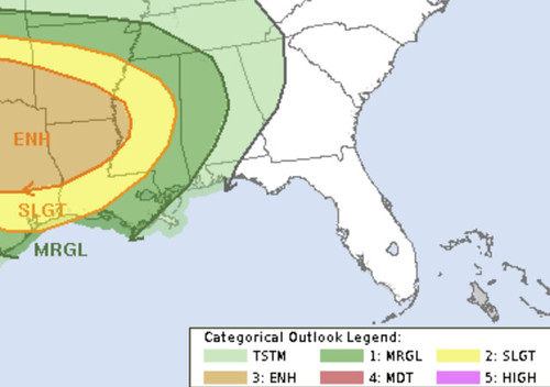
Meanwhile, strong to severe thunderstorms in the plume — perhaps as an MCS — may move eastward across the Delta region, with the potential to outpace the favorable surface-based destabilization farther east. Accordingly, the eastern bounds of overnight severe potential are still very uncertain and broadly gradated for now.
Given little if any capping extending southwestward ahead of the dryline, other storms may form by 18Z across AL, southern MS and LA. Some models develop a significant amount of storms along the Gulf Coast, which may inhibit destabilization to the north.

Low-level shear for tornadoes will be most favorable early in the day across LA/MS/AL, and later in the day across GA and SC near the warm front. Adding uncertainty to this forecast is potential outflow boundaries from the early day storms, and questions regarding airmass recovery in those areas (northern GA and SC). Tornado and wind risk will largely depend on storm mode.

If midday heating occurs along the dryline, and the air mass has not been overturned, supercells and tornadoes will be possible. A few strong tornadoes might occur should sufficient SRH (200-300+ m2/s2) remain prior to 850 mb winds veering. Tornadoes will also be possible along the warm front into GA/SC, assuming it is not reinforced with too much outflow. Otherwise, a general upscale growth of storms is expected for the remainder of the area including FL. Damaging winds are most likely should the storm mode be linear. Given such large model variability, large changes in area are possible in later updates.
The Setup
The next system – complete with a Texas Dryline – will move from West TExas through the southeast during the next 24 hours.
As noted by the Storm Prediction Center, it looks like the storms in Texas this afternoon should collect into a small MCS that slides by – perhaps to the north – later this evening and falls apart. That leaves southern Louisiana, southern Mississippi and southern Alabama with a chance for some storms, but the overall threat for severe weather should be minimized. Even if storms do hold together, it looks like storm mode will be more elevated, rather than surface-based, and that would limit the tornado threat.
That changes overnight and then into tomorrow morning. That is when the second wave of storms moves into the region. This time, storms will be moving through an airmass that will allow the storms to be surface-based. That means an increased threat for stronger wind, small hail and tornadoes.

That Skew-T from the 14z HRRR model shows that the atmosphere will be moderately unstable, and highly sheared. This is, historically, a more common setup for severe weather along the Gulf Coast.
The near-storm environment at this time from the HRRR is a bit more robust as you move closer to where the model suggests storm would be at this point. But not noteworthy enough to change the forecast.
The Karrie Meter

Ran the numbers from the morning data and it came back a bit higher than expected. I will say that this is going to be highly dependant on if any off-shore storms develop. It was interesting to see that the atmosphere across the region becomes much more favorable for storms in the afternoon, but the forcing for storm development has already moved east. So a lot of this is going to be about timing.
When you average all of the model data out, it shows a final Karrie Meter value of 5.51. That is the “Pacing Around the Living Room” level.

This is 1.4 lower than this past Sunday and 0.78 lower than Easter.
The Timeline & Threats
Rain and storms will begin as early as 10am. It looks like the threat for severe weather will begin around 9pm and last through about 9am Thursday morning. That said, there will be a break between about 1am and 4am.
The main threats….
| THREATS | THREAT LEVEL (out of 5) | NOTES |
| Flooding | 3 | Up to 2″ of rain possible |
| Wind | 3 | Up to 65mph gusts possible |
| Hail | 1 | Up to half dollar-sized hail |
| Tornado | 2 | Up to EF-2 possible |
| Lightning | 2 | Frequent lightning |
The threat for tornadoes is lower with his event than the last two – in both frequency and potency.
That said, an EF-2 is still a destructive tornado. Even an EF-2 will do considerable damage to structures. So please take these warnings seriously.
The Bottom Line
Storms will be possible Wednesday night between about 9pm and 1am Thursday morning. These are unlikely to be tornado-producing and few – if any – will be severe. Then there will be a break from 1am through about 4am. By 4am Thursday morning, more storms will move into the area, these may be severe.
A lot like last time, here is a breakdown of who sees what…
Many places: Rain, lightning, wind up to 45mph
Some places: Rain, flash flooding, frequent lightning, wind gusts up to 65mph and hail
Few places: Very heavy rain, flash flooding, frequent lightning, wind gusts up to 65mph, hail, and a tornado
The thing that we are going to work at figuring out during the next 12 hours is if the first MCS will “work-over” the atmosphere at all. And how that may change what happens with the second round of storms.


Thanks again, Nick
Thanks for the update. Also, the gif is from Stranger Things. Great show, check it out!
Another great job! Thank you Nick.